
Football weather kind of weekend for western PA
Brisk days will turn into frosty nights with dry conditions this weekend.
920 IS OUR TIME. WE’RE GOING TO GET YOU ANOTHER CHECK OF YOUR CERTIFIED MOST ACCURATE FORECAST. IF YOU’RE ONE OF THE LUCKY ONES HEADING DOWN TO THE GAME TOMORROW, YOU WANT TO BUNDLE UP. I KNOW IT’S PROBABLY THE CHILLIEST GAME OF THE YEAR SO FAR, AS WE ARE EXPECTING SOME GOOD FOOTBALL WEATHER, NOT JUST TOMORROW NIGHT, BUT ALSO TODAY AS WELL AS PITT WILL TAKE THE FIELD. SUNSHINE IS MAKING A COMEBACK. YOU’RE PROBABLY SEEING THAT STREAMING THROUGH YOUR WINDOWS AT HOME HERE THIS MORNING. WE HAVE LOTS OF BLUE SKY OUT THERE RIGHT NOW. SOME CLOUDS WILL TRY AND WANDER IN, BUT OVERALL TODAY A WHOLE LOT BRIGHTER THAN IT’S BEEN OVER THE PAST COUPLE OF DAYS. WE’VE BEEN PLAGUED WITH THOSE CLOUDS, OCCASIONAL SHOWERS. RAIN IS GOING TO STAY AWAY, NOT JUST TODAY, BUT ALSO THROUGH THE REMAINDER OF THE WEEKEND AS THOSE CLOUDS DURING THE DAY START TO BREAK UP A LITTLE LATER ON TONIGHT, ANOTHER OPPORTUNITY FOR A FROST FREE SITUATION ACROSS WESTERN PENNSYLVANIA. LAST NIGHT’S FREEZE WARNING JUST INTO OUR SOUTHWESTERN COUNTIES. THAT’S WASHINGTON, GREENE, FAYETTE. ALL THAT FREEZE WARNING HAS EXPIRED NOW, BUT MORE THAN LIKELY IT WILL BE RE-UPPED BY THE NATIONAL WEATHER SERVICE. AS WE GO THROUGH THIS AFTERNOON LOOKING TOWARDS TONIGHT’S LOWS, TEMPERATURES DOWN CLOSE TO THE FREEZING MARK, EVEN IN CRANBERRY, WAYNESBURG. ALSO INDIANA 36. OUR FORECAST LOW FOR THE CITY OF PITTSBURGH, ALSO MID 30S. WE HEAD INTO UNIONTOWN MORGANTOWN AS WELL. SO AGAIN, GOOD IDEA TO KEEP THOSE PLANS COVERED UP. BRING THEM INDOORS. AND ALSO MORE THAN LIKELY YOU’RE GOING TO WAKE UP TO A LITTLE MORE FROST IN THE PUMPKIN TOMORROW. AND SPEAKING OF THAT, FROST LOWS ARE GOING TO STAY IN THE 30S FOR THE FORESEEABLE FUTURE. OUR HIGHS STILL FEELING A LITTLE BIT MORE LIKE NOVEMBER AS WE GET SET TO WIND DOWN. OCTOBER COMING UP THIS WEEK WITH HIGH TEMPERATURES, WILL BE STAYING PUT IN THE MID TO UPPER 50S, AT LEAST FOR RIGHT NOW. AGAIN, LOOKING AT TEMPERATURES RIGHT NOW, COMING OFF OF THAT FROSTY MORNING, STILL CLOSE TO THE MID 30S, WE CHECK INTO SPOTS LIKE WASHINGTON. MEANWHILE IT IS 37 FOR CRANBERRY NEW CASTLE KITTANNING AS WELL. ONE BETTER OUT OF PITTSBURGH INTERNATIONAL ALREADY IN THE 40S FOR INDIANA, MONROEVILLE AND FRANKLIN HERE. AS WE GET YOUR SATURDAY STARTED, HERE’S A LIVE LOOK AT ALL THREE RIVERS WITH ACTION CAM. OF COURSE, THINGS WILL GET A LITTLE BIT BUSIER AS WE APPROACH NOONTIME ON THE NORTH SHORE. BY THAT POINT, TEMPERATURES SHOULD BE WORKING INTO THE LOWER 50S. SHOULD ENJOY A GOOD AMOUNT OF SUNSHINE THROUGH THAT. ABOUT THAT POINT IN THE DAY, AS WE WORK THROUGH THE AFTERNOON, MORE THOSE CLOUDS FILTERING IN AS WINDS START TO SHIFT, COMING IN MORE OUT OF THE NORTH. BUT THEY’RE NOT GOING TO BRING ANY RAIN CHANCES FOR US. THAT’S GOING TO STAY AWAY, NOT JUST THROUGH THIS WEEKEND, BUT EVEN FAST FORWARDING INTO THE START OF NEXT WEEK, HERE’S FUTURECAST AROUND NOONTIME, THE ONLY SPOT THAT COULD CATCH A VERY ISOLATED SHOWER WILL BE UP ALONG I-80. BUT FOR THE MOST PART, THOSE SHOWERS STAY BOTTLED UP CLOSER TO THE SHORE OF LAKE ERIE. FOR EVERYBODY ELSE, INTERVALS OF SUNSHINE AND CLOUDS. THOSE CLOUDS, THOUGH, QUICKLY MOVE OUT AS THE SUN GOES DOWN WITH SEVERAL HOURS, I SHOULD SAY, OF CLEAR CONDITIONS. THAT’S GOING TO ALLOW THOSE TEMPERATURES TO DROP PRETTY STEADILY. SO GET AREA WISE FROST, IF NOT A FREEZE. SOME OF THE COLDEST TEMPERATURES WILL BE IN OUR RIVER VALLEY LOCATIONS OUTSIDE OF SOME HIGH LEVEL CLOUDS. LOOKING AT MOSTLY SUNNY CONDITIONS AS WE WORK THROUGH YOUR SUNDAY TEMPERATURES, THOUGH, ARE GOING TO BE GETTING CHILLY IN A HURRY, ESPECIALLY UNDER THE LIGHTS AT ACRISURE STADIUM. SO AS WE BREAK DOWN YOUR STEELERS GAME DAY FORECAST, TAILGATING TEMPERATURES VERY MUCH LIKE TODAY. YOU’LL BE IN THE MID 50S AROUND THE 820 KICKOFF. ALREADY IN THE LOWER 50S. MOST OF THE GAME AGAIN AGAINST THE PACKERS WILL BE IN THE 40S. SO CERTAINLY A NIGHT WHERE YOU WANT TO LAYER UP IF YOU’RE HEADING TO THE GAME. STILL DRY MONDAY AND TUESDAY, THINGS START TO CHANGE JUST SLIGHTLY AS WE MONITORING A SYSTEM TRYING TO WORK ITS WAY UP THE EASTERN SEABOARD. THAT’S GOING TO BE WEDNESDAY THROUGH THE END OF THE MONTH. SO THAT COULD BRING US SOME SHOWER CHANCES. AT THIS POINT. THOSE SHOWERS ON HALLOWEEN LOOK TO BE EARLY IN THE DAY SHOULDN’T BE AN ISSUE FOR ANY OF THE GHOSTS, GOBLINS, EVEN THE LITTLE WITCHES THAT MAY BE OUT RUNNING ABOUT DON’T NEED TO WORRY ABOUT THEM MELTING, BUT IT IS GOING TO BE A LITTLE BIT OF A COOL NIGHT FRIDAY ACROSS WESTERN PENNSYLVANIA. SO MAYBE LOOKING FOR SOME LAYERS UNDERNEATH THOSE COSTUMES. NO MELTING, BUT MAYBE A LITTLE SHIVERING. SHIVERIN
Football weather kind of weekend for western PA
Brisk days will turn into frosty nights with dry conditions this weekend.

Updated: 10:38 AM EDT Oct 25, 2025
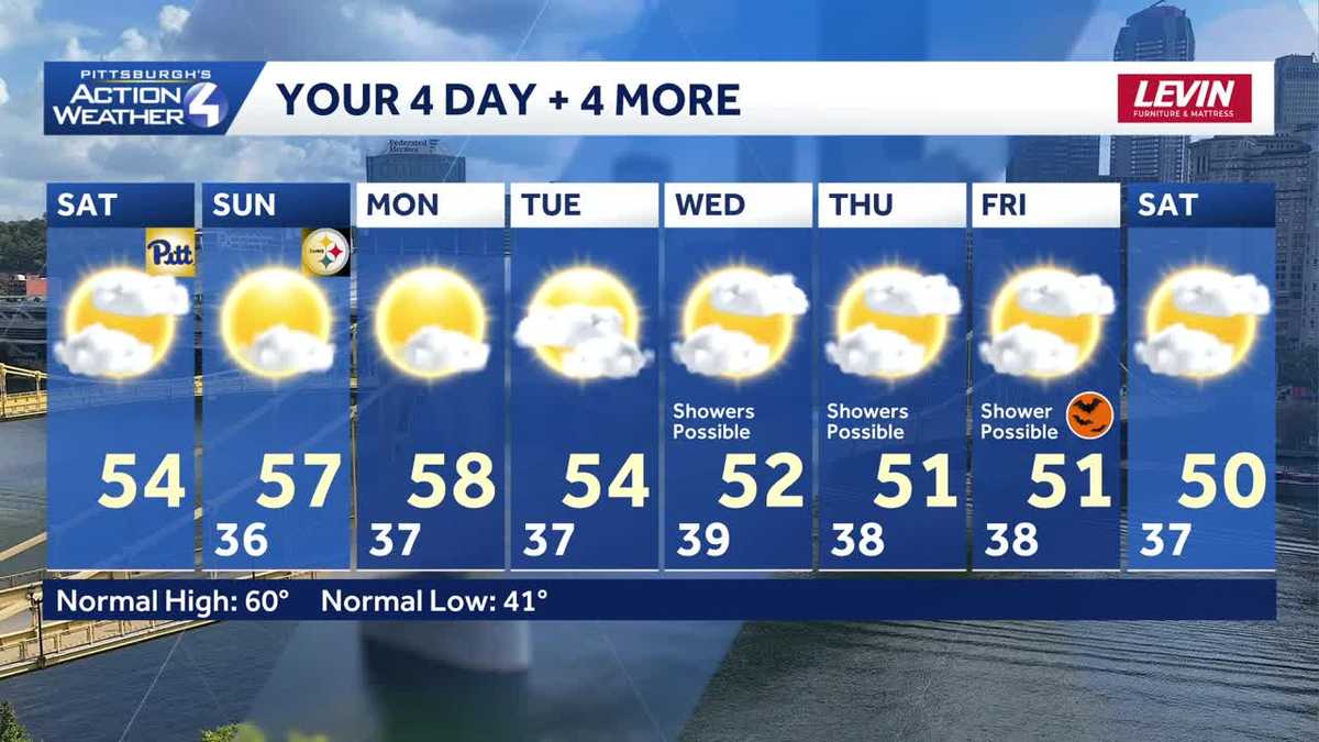
Football weather will be in the air this weekend. Today will feature intervals of sun and clouds and seasonably cool temperatures in the mid 50s. The dry conditions will extend into the start of next week.Another night of frosty and freezing temperaturesTonight will feature a better frost/freeze potential with clear conditions for most of the night. Low temperatures around Allegheny County will likely be in the frosty range – around 36 degrees – while outlying spots, especially in the valleys, could see a freeze. Another Freeze Warning will likely be issued.Football weather this weekendDespite the return to sunshine, temperatures will only climb into the middle 50s this weekend. Pretty nice temperatures for the Pitt game this afternoon and tailgating for the Steelers game. It will be in the 40s for most of the Steelers-Packers game.Seasonably cool to finish OctoberA cooler than normal trend persists through the end of October. The weekend sunshine won’t last long as another system will roll in for the middle of next week. Showers are possible late Wednesday. The track of this next system is still a question, that will ultimately determine when and where rain will fall. We are continuing to monitor the trick-or-treat forecast. As of now, any showers could linger into early Friday but we should dry out for all the ghosts and goblins on Halloween night.TODAY: Brisk with gradual clearing. High: 54°.TONIGHT: Fair skies with frosty or freezing temperatures. Low: 36°.SUNDAY: Mostly sunny and cool. High: 56°, low: 37°.MONDAY: Patchy morning frost. Sun and clouds. High: 57°, low: 37°.
PITTSBURGH —
Football weather will be in the air this weekend. Today will feature intervals of sun and clouds and seasonably cool temperatures in the mid 50s. The dry conditions will extend into the start of next week.
Another night of frosty and freezing temperatures
Tonight will feature a better frost/freeze potential with clear conditions for most of the night. Low temperatures around Allegheny County will likely be in the frosty range – around 36 degrees – while outlying spots, especially in the valleys, could see a freeze. Another Freeze Warning will likely be issued.

Hearst OwnedHearst
A better set-up for areas of frost tonight.
Football weather this weekend
Despite the return to sunshine, temperatures will only climb into the middle 50s this weekend. Pretty nice temperatures for the Pitt game this afternoon and tailgating for the Steelers game. It will be in the 40s for most of the Steelers-Packers game.

Hearst OwnedHearst
A chilly night under the lights of Acrisure Stadium Sunday night.
Seasonably cool to finish October
A cooler than normal trend persists through the end of October. The weekend sunshine won’t last long as another system will roll in for the middle of next week. Showers are possible late Wednesday. The track of this next system is still a question, that will ultimately determine when and where rain will fall. We are continuing to monitor the trick-or-treat forecast. As of now, any showers could linger into early Friday but we should dry out for all the ghosts and goblins on Halloween night.

Hearst OwnedHearst
October will end on cool note. We are watching shower chances starting on Wednesday.
TODAY: Brisk with gradual clearing. High: 54°.
TONIGHT: Fair skies with frosty or freezing temperatures. Low: 36°.
SUNDAY: Mostly sunny and cool. High: 56°, low: 37°.
MONDAY: Patchy morning frost. Sun and clouds. High: 57°, low: 37°.