
Two systems threaten New England ahead of Patriots playoff game
CONFETTI BECAUSE THEY’VE WON. WHAT DO YOU THINK ABOUT THAT AGE? I LIKE THE SOUND OF THAT. THAT THAT SOUNDS AWESOME. HEY, YOU KNOW WHAT? WE’RE GOING TO LOOK AT THE 12 HOUR FORECAST HERE FOR BOSTON OKAY. AND YOU’RE GOING TO SAY WHAT SNOW. HOW IS IT GOING TO SNOW WHEN IT’S 3839 DEGREES OUTSIDE. WELL THIS IS FOR BOSTON AND THE IMMEDIATE AREA. SO YOU CAN SEE HERE THAT WE DO MAKE IT UP INTO THE UPPER 30S. TOMORROW WE WILL HAVE A LITTLE BIT OF SUNSHINE IN THE MORNING, BUT AN AWFULLY CLOUDY MIDDAY AND AFTERNOON TIME FRAME FEELS LIKE TEMPERATURES WON’T BE TOO TOUGH TO TAKE EITHER. SO WHERE IS THIS SNOW WE’RE TALKING ABOUT? WELL, OVER THE NEXT 12 HOURS, THAT LIGHT SNOW WILL BE INCHING CLOSER TO WESTERN PARTS OF WORCESTER COUNTY, THE WORCESTER HILLS. IT SHOULD BE SNOWING THERE BY MORNING. WE’VE GOT TWO ROUNDS OF THAT SNOW FOR THE HOLIDAY WEEKEND, ONE IN THE FORM OF SOME LIGHT RAIN AND SNOW TOMORROW, AND THE OTHER ONE COMING IN FOR SOUTHEASTERN MASSACHUSETTS SPECIFICALLY ON SUNDAY. WHERE IS THE FIRST SYSTEM? WELL, YOU CAN KIND OF SEE IT TAKING SHAPE HERE. WE’VE GOT A SWIRL UP THIS WAY. LOW PRESSURE PRECIPITATION DOWN THIS WAY. AND THE TWO WORK IN CONCERT TO BRING US OUR BOUT WITH SOME SNOW IN SOME AREAS FOR TOMORROW. 19 TO 27 DEGREES WARMEST DOWN TOWARD THE CAPE AND THE ISLANDS. COLDEST. WELL NORTH AND WEST UP INTO THE HILLS OF WORCESTER COUNTY. TOMORROW, 33 TO 45 WARMEST AGAIN DOWN TOWARD THE CAPE AND THE ISLANDS INTO THE BOSTON AREA, AND THEN COLDEST, WHERE WE ACTUALLY HAVE THE SNOW. SO WHERE IS THAT SNOW GOING TO BE? ALL RIGHT. WELL, THE AREA OF LOW PRESSURE BRINGS THAT SNOW INTO PORTIONS OF WORCESTER COUNTY, SOUTHWEST NEW HAMPSHIRE, AND BACK INTO THE WESTERN HALF OF THE STATE. THAT’S WHERE I THINK YOU’RE GOING TO SEE YOUR WELL, LET’S CALL IT YOUR HIGHEST SNOW TOTALS. THEY’RE NOT GOING TO BE TERRIBLY HIGH, BUT THAT’S WHERE YOU’LL SEE THE BULK OF YOUR PRECIPITATION. THEN WE GET INTO SUNDAY. AND THIS IS A STORM SYSTEM THAT’S OUT HERE ACTUALLY. BUT IT’S CLOSE ENOUGH TO FLING ITS NORTHWESTERN SHIELD OF PRECIPITATION INTO SOUTHEASTERN MASSACHUSETTS. SO HERE’S THE SNOW FOR TOMORROW. NOTICE IT KIND OF MARKS TIME RIGHT UP HERE ALONG THE 495 BELT HERE. SO IT’S WEST OF WORCESTER, UP INTO THE ROUTE TWO CORRIDOR. THAT’S GOING TO SEE THE THE BULK OF THE PRECIPITATION ONCE IT REACHES BOSTON IT’S A LOT LESS. IT WILL COME THROUGH QUICKLY. IT’S A FEW SHOWERS WET SNOWFLAKES. AND I THINK THE CAPE AND THE ISLANDS SEE VERY LITTLE FROM THAT SYSTEM. WE’LL TALK ABOUT SUNDAY MOMENTARILY. SO AGAIN OUT TOWARD THE WORCESTER HILLS, 3 TO 5IN OF SNOW IS POSSIBLE, 1 TO 3IN AROUND THE WORCESTER AREA UP TOWARD THE MERRIMACK VALLEY. BUT THEN AMOUNTS DROP AS YOU GET TOWARD THE CITY VERY MUCH. NOTHING AROUND THE SOUTH SHORE COMMUNITIES. THEN SUNDAY COMES AND HERE WE GO. WITH THE SNOW STARTING TO EXPAND INTO SOUTHEASTERN MASSACHUSETTS. REMEMBER, IT WAS HERE. TOMORROW. IT WILL BE HERE ON SUNDAY, AND IT’S MARGINAL TEMPERATURE WISE. SO THAT, YOU KNOW, WE MAY LOSE A LITTLE BIT OF THE SNOW TO MELTING DOWN TOWARD PARTS OF THE CAPE AND THE ISLANDS. WOULDN’T SURPRISE ME ON NANTUCKET TO SEE SOME MIXING DOWN THAT WAY. IT DOESN’T MAKE IT TOO FAR INLAND. IT’S REALLY FROM BOSTON, DOWN THROUGH PROVIDENCE, AND POINTS TO THE SOUTH AND EAST. NOW, COULD THIS JOG A LITTLE BIT TOWARD THE TOWARD THE NORTHWEST? SURE. SO THAT’S WHY I’M GOING ABOUT 2 TO 4IN, INCLUDING JUST ABOUT ALL OF PLYMOUTH AND BRISTOL COUNTIES, MAYBE UP TOWARD THE BOSTON AREA, LIKE BRAINTREE, FOR EXAMPLE, AND THE CAPE AND THE ISLANDS. IT’S GOING TO TURN COLDER BEHIND THIS STORM SYSTEM, AS YOU’LL SEE ON THE SEVEN DAY FORECAST. THERE YOU GO. WE GOT A PAIR OF 30 NINES TOMORROW AND SUNDAY 33 THOUGH ON MONDAY. AND ONCE WE’RE HEADING BACK TO WORK AND SCHOOL ON TUESDAY, DON’T FORGET WE’VE GOT THE HOLIDAY MONDAY. TEMPERATURES WILL BE I
Two systems threaten New England ahead of Patriots playoff game

Updated: 7:39 PM EST Jan 16, 2026
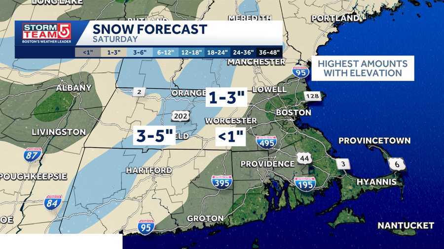
The Patriots are heading into a do-or-die game against the Houston Texans at Gillette Stadium on Sunday at 3 p.m., and two weather systems threaten to bring some snow to southern New England.”Our next threat two rounds of snow for this holiday weekend. It’ll be some light snow and rain on Saturday, and some snow, likely over southeastern Massachusetts on Sunday,” StormTeam 5 meteorologist A.J. Burnett said. On Saturday, a few light snow showers may begin as early as the pre-dawn hours in central and western Massachusetts. Steadier light snow will develop around midday or just after noon, mixing with rain around the city and points south, but staying snow along and northwest of Route 128.But another system for Sunday has been showing up on forecast models for the last several days, but has differed drastically in track and intensity of the storm.The storm will remain offshore, but will be close enough for at least some snow along parts of the South Coast and Cape. There’s even a chance for some very light snow as far north as Boston and up toward the Interstate 95 corridor.”It’s really southeastern Massachusetts that has the best chance of picking up that snow. I think the best chance for 2 to 4 inches of snow would be over Plymouth, Bristol counties down toward the Cape and the islands, with lesser amounts toward the north and west,” Burnett said.The snow is expected to be light and will move out of the region relatively quickly.Colder air will fill in behind this second storm, capping high temperatures in the 20s by Tuesday and Wednesday of next week.
BOSTON —
The Patriots are heading into a do-or-die game against the Houston Texans at Gillette Stadium on Sunday at 3 p.m., and two weather systems threaten to bring some snow to southern New England.
“Our next threat two rounds of snow for this holiday weekend. It’ll be some light snow and rain on Saturday, and some snow, likely over southeastern Massachusetts on Sunday,” StormTeam 5 meteorologist A.J. Burnett said.
On Saturday, a few light snow showers may begin as early as the pre-dawn hours in central and western Massachusetts. Steadier light snow will develop around midday or just after noon, mixing with rain around the city and points south, but staying snow along and northwest of Route 128.
But another system for Sunday has been showing up on forecast models for the last several days, but has differed drastically in track and intensity of the storm.

The storm will remain offshore, but will be close enough for at least some snow along parts of the South Coast and Cape. There’s even a chance for some very light snow as far north as Boston and up toward the Interstate 95 corridor.
“It’s really southeastern Massachusetts that has the best chance of picking up that snow. I think the best chance for 2 to 4 inches of snow would be over Plymouth, Bristol counties down toward the Cape and the islands, with lesser amounts toward the north and west,” Burnett said.
The snow is expected to be light and will move out of the region relatively quickly.
Colder air will fill in behind this second storm, capping high temperatures in the 20s by Tuesday and Wednesday of next week.