

Erin is forecast to rapidly intensify into a Category 4 hurricane late this weekend or early next week, marking the first major hurricane of the Atlantic season. AccuWeather experts warn that the storm could bring dangerous surf, flooding rains, and gusty winds to parts of the Caribbean and potentially impact the U.S. East Coast.
What to Know:
Erin is expected to reach Category 4 strength with winds up to 156 mph.
The storm will pass about 200 miles north of Puerto Rico as a Category 3. Outer bands may bring 2–4 inches of rain to Puerto Rico and the Virgin Islands.
Storm surge of 1–3 feet could cause coastal flooding in the northern Leeward Islands.
Dangerous rip currents and 10–15 foot waves forecast for U.S. East Coast beaches.
Bermuda could see wind gusts up to 80 mph and up to 8 inches of rain.
AccuWeather warns of possible beach erosion in the Outer Banks.
Two additional tropical waves are being monitored for development.
AccuWeather® forecasts 13–18 named storms this season, with up to 5 major hurricanes.
This live blog is now closed.
03:58 PM EDT
Erin set to rapidly intensify as AI forecasting gains ground
Hurricane Erin is expected to undergo rapid intensification starting Friday night, fueled by exceptionally warm sea surface temperatures and low wind shear across the western Atlantic. AccuWeather Lead Hurricane Expert Alex DaSilva told Newsweek that the storm has so far strengthened gradually due to lingering dry air. Still, conditions are now primed for a burst of intensification through the weekend.
Forecast models—including emerging AI-based systems—are showing strong consensus that Erin could reach Category 4 strength by Sunday. These AI models, which use pattern recognition and historical analogs, are being integrated with traditional physics-based systems to improve forecast accuracy.
“These new models have not been around for very long. It’s still early to draw major conclusions on which one is better, but there have been some promising results from some of the AI models that we’ve worked with over the last couple of years,” he said via email. “AI models will play a big role in hurricane forecasting over the next few years. They are another great tool in the toolbox to help us forecast the weather. You still need experienced meteorologists to interpret the data. AccuWeather has more than 100 expert meteorologists on our staff who use a hybrid AI approach, combining state-of-the-art machine learning with our expertise to create our forecasts.”
As Erin intensifies offshore, its impacts will be felt along the U.S. East Coast. Dangerous rip currents and high surf are expected from Florida to New England next week, with the Outer Banks and Mid-Atlantic beaches particularly vulnerable to erosion and flooding. DaSilva urged beachgoers to heed lifeguard warnings and avoid swimming in unguarded areas.
With hurricane season entering its peak, forecasters stress the importance of monitoring updates and preparing for indirect coastal hazards—even from storms that remain offshore.
03:39 PM EDT
Hurricane Erin intensifies as Gulf System brings flood risk to Texas
Meteorologists are closely tracking Hurricane Erin, now poised to become the first major hurricane of the 2025 Atlantic season. The storm is expected to rapidly intensify into a Category 3 by Saturday and possibly reach Category 4 strength as it moves northwest of the Greater Antilles. While a direct U.S. landfall remains unlikely, forecasters warn of dangerous surf and rip currents along the East Coast from Florida to Atlantic Canada next week.
AccuWeather’s Lead Hurricane Expert Alex DaSilva shared in a briefing this morning some major developments.
Key Developments:
Erin’s forecast cone spans from the Carolinas to Bermuda, with track uncertainty hinging on storm speed and steering currents.
Feeder bands may bring heavy rain and localized mudslides to Caribbean islands, though no direct hit is expected.
Massive waves—up to 75 feet offshore—could generate 10–15 foot surf along the Carolinas, with beach erosion and flooding possible from the Outer Banks to Virginia Beach.
Rip current risk will be high across East Coast beaches during peak vacation weeks.
Meanwhile, a separate tropical disturbance in the western Gulf is pushing ashore near Brownsville, Texas, and northern Mexico. Though hurricane hunters found no circulation, the system is producing heavy rain and flash flooding risks in South Texas and the Texas Hill Country. Most rainfall is expected to remain south of key rebuilding zones.
Forecasters are also monitoring two new tropical waves off Africa, one of which may follow a similar track to Erin later this season.
02:40 PM EDT
Top strongest and deadliest hurricanes in the history of US
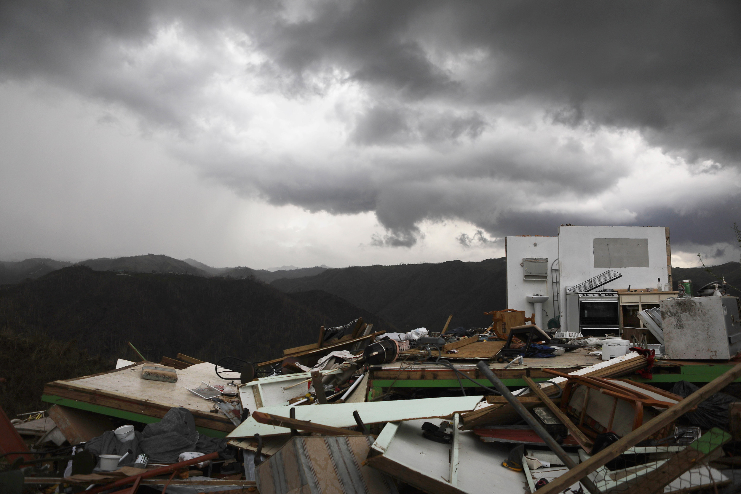
The remnants of a destroyed home stand more than two weeks after Hurricane Maria hit the island on October 6, 2017 in Morovis, Puerto Rico.
The remnants of a destroyed home stand more than two weeks after Hurricane Maria hit the island on October 6, 2017 in Morovis, Puerto Rico.
Mario Tama/Getty Images
1. Great Galveston Hurricane (1900)
Fatalities: At least 8,000 (possibly up to 12,000)
Impact: Flattened Galveston, Texas; remains the deadliest natural disaster in U.S. history.
2. Hurricane Maria (2017)
Fatalities: Estimated 2,975
Impact: Devastated Puerto Rico; widespread infrastructure collapse and prolonged recovery.
3. 1928 Okeechobee Hurricane
Fatalities: ~2,500
Impact: Massive lake surge drowned communities around Lake Okeechobee in Florida.
4. Hurricane Katrina (2005)
Fatalities: ~1,200
Impact: Catastrophic flooding in New Orleans due to levee failures; widespread Gulf Coast damage.
5. Chenière Caminada Hurricane (1893)
Fatalities: ~2,000
Impact: Destroyed a Louisiana fishing village; widespread coastal devastation.
6. Sea Islands Hurricane (1893)
Fatalities: ~2,000
Impact: Hit Georgia and South Carolina; left 30,000 homeless.
7. Georgia/South Carolina Hurricane (1881)
Fatalities: ~700
Impact: Struck at high tide; caught coastal residents off guard.
8. Hurricane Audrey (1957)
Fatalities: 416
Impact: Slammed into Louisiana and Texas; deadly storm surge.
9. Labor Day Hurricane (1935)
Fatalities: 408
Impact: Most intense U.S. landfalling hurricane; hit Florida Keys.
10. Last Island Hurricane (1856)
Fatalities: 400
Impact: Washed away a Louisiana resort island; split the landmass in two.
02:27 PM EDT
See satellite images of Erin
NOAA’s GOES-19 satellite captured the formation of Hurricane Erin early Friday, marking the first hurricane of the 2025 Atlantic season. The storm is currently swirling about 1,000 miles east of the northern Leeward Islands and is expected to intensify rapidly over the weekend.
02:10 PM EDT
Erin to pass east of Bahamas; no direct impact expected in South Florida
Forecasters say Hurricane Erin will remain well offshore as it moves past the Bahamas early next week, with no direct impacts expected in South Florida. The storm, currently strengthening in the Atlantic, is projected to curve northward before nearing the U.S. coastline.
Local meteorologists note that slightly drier continental air may be drawn into South Florida as Erin passes, potentially reducing afternoon rain chances. While the region will avoid the brunt of the storm, residents are advised to stay alert for elevated surf and rip current risks along Atlantic beaches.
As #Erin passes east of the Bahamas next week, we’d like to once again reiterate that no direct impacts are expected here in South Florida.
In fact, slightly drier continental air (green/blue colors) may be drawn southward into our area acting to reduce afternoon rain chances. https://t.co/D1aYVkGZaX pic.twitter.com/CUlLjRSPmo
— NWS Miami (@NWSMiami) August 15, 2025
01:58 PM EDT
Hurricane gains strength as it nears Leeward Islands
The National Hurricane Center (NHC) is issuing active advisories for Hurricane Erin, currently moving west-northwest at 17 mph across the Atlantic. As of 2:00 PM AST on Friday, Erin was located near 18.6°N, 56.8°W, with maximum sustained winds of 75 mph and a central pressure of 993 mb.
Marine warnings are in effect across the Atlantic, Caribbean, and southwestern North Atlantic, with Erin expected to pass near or north of the Leeward Islands on Saturday. The storm remains a focal point in NOAA’s ongoing forecast for an above-average Atlantic hurricane season.
The NHC has released updated products and services for the 2025 season, including key messages in both English and Spanish, satellite imagery, wind speed probabilities, and interactive forecast maps. No tropical cyclones are currently active in the Eastern or Central Pacific regions.
01:41 PM EDT
Why you can’t name a hurricane after yourself
If you’ve ever wondered whether a tropical cyclone could bear your name, the answer is no. The naming of storms is overseen by an international committee within the United Nations’ World Meteorological Organization (WMO), not by individuals or national agencies.
For the Atlantic basin, the WMO maintains six rotating lists of names, reused every six years. Names are only changed if a storm is so deadly or costly that reusing it would be insensitive. In such cases, the name is retired and replaced during the committee’s annual meeting.
So while you might spot a storm with a familiar name, it’s not a personal tribute—it’s part of a standardized global system designed to improve communication and public safety during severe weather events.
01:28 PM EDT
California sends aid to Puerto Rico ahead of Hurricane Erin
California Governor Gavin Newsom announced the deployment of state resources to Puerto Rico in preparation for Tropical Storm, now Hurricane Erin yesterday. The move underscores California’s commitment to supporting disaster response efforts beyond its borders.
“We’re glad to help coordinate life-saving response to Americans in harm’s way,” Newsom said in a statement on social media. The assistance may include emergency personnel, equipment, and logistical support as Puerto Rico braces for potential flooding and wind damage.
The storm is expected to intensify as it approaches the island, prompting federal and state agencies to mobilize in advance.
I just approved the deployment of California resources to Puerto Rico ahead of Tropical Storm Erin.
We’re glad to help coordinate life-saving response to Americans in harm’s way.
— Governor Gavin Newsom (@CAgovernor) August 14, 2025
01:14 PM EDT
Rest of 2025 Atlantic storm names revealed
As the 2025 Atlantic hurricane season enters its peak months, the National Hurricane Center has begun assigning names from its official list, starting with Andrea and currently up to Erin. The list, maintained by the World Meteorological Organization, includes 21 names reused every six years unless retired due to severe impacts.
This year’s lineup features Dexter, replacing Dorian, which was retired after its catastrophic damage in 2019. Two names—Van and Wendy—are appearing for the first time. With forecasters predicting an above-average season of 13 to 19 named storms, the full list may be exhausted, triggering a supplemental naming system.
Tropical Storm Erin, the fifth named storm of the season, is currently strengthening in the eastern Atlantic and could become the first hurricane of the year by midweek.
Here are the rest of the names for the 2025 Atlantic storms:
Andrea
Barry
Chantal
Dexter
Erin
Fernand
Gabrielle
Humberto
Imelda
Jerry
Karen
Lorenzo
Melissa
Nestor
Olga
Pablo
Rebekah
Sebastien
Tanya
Van
Wendy
01:05 PM EDT
Erin threatens Caribbean, Puerto Rico with heavy rain
Hurricane Erin intensified Friday as it neared the northeast Caribbean, prompting tropical storm watches across several islands and raising concerns over flooding and landslides. The system, now packing sustained winds of 75 mph, was located roughly 460 miles east of the Northern Leeward Islands and moving west-northwest at 18 mph.
Tropical storm watches were issued for Anguilla, Barbuda, St. Martin, St. Barts, Saba, St. Eustatius, and St. Maarten. Forecasters expect up to 6 inches of rain in parts of Puerto Rico, the Virgin Islands, and Antigua and Barbuda, with dangerous surf and rip currents likely to follow.
Meteorologists say Erin will likely veer northeast between the U.S. mainland and Bermuda, sparing direct landfall but still posing risks. Accuweather warns of 15-foot waves and beach erosion along the North Carolina coast next week.
Erin is the first hurricane of the 2025 Atlantic season and could reach Category 4 strength over unusually warm ocean waters. The season is forecast to be active, with up to 10 hurricanes expected, including several major storms.
12:51 PM EDT
Understanding hurricane categories and wind speeds
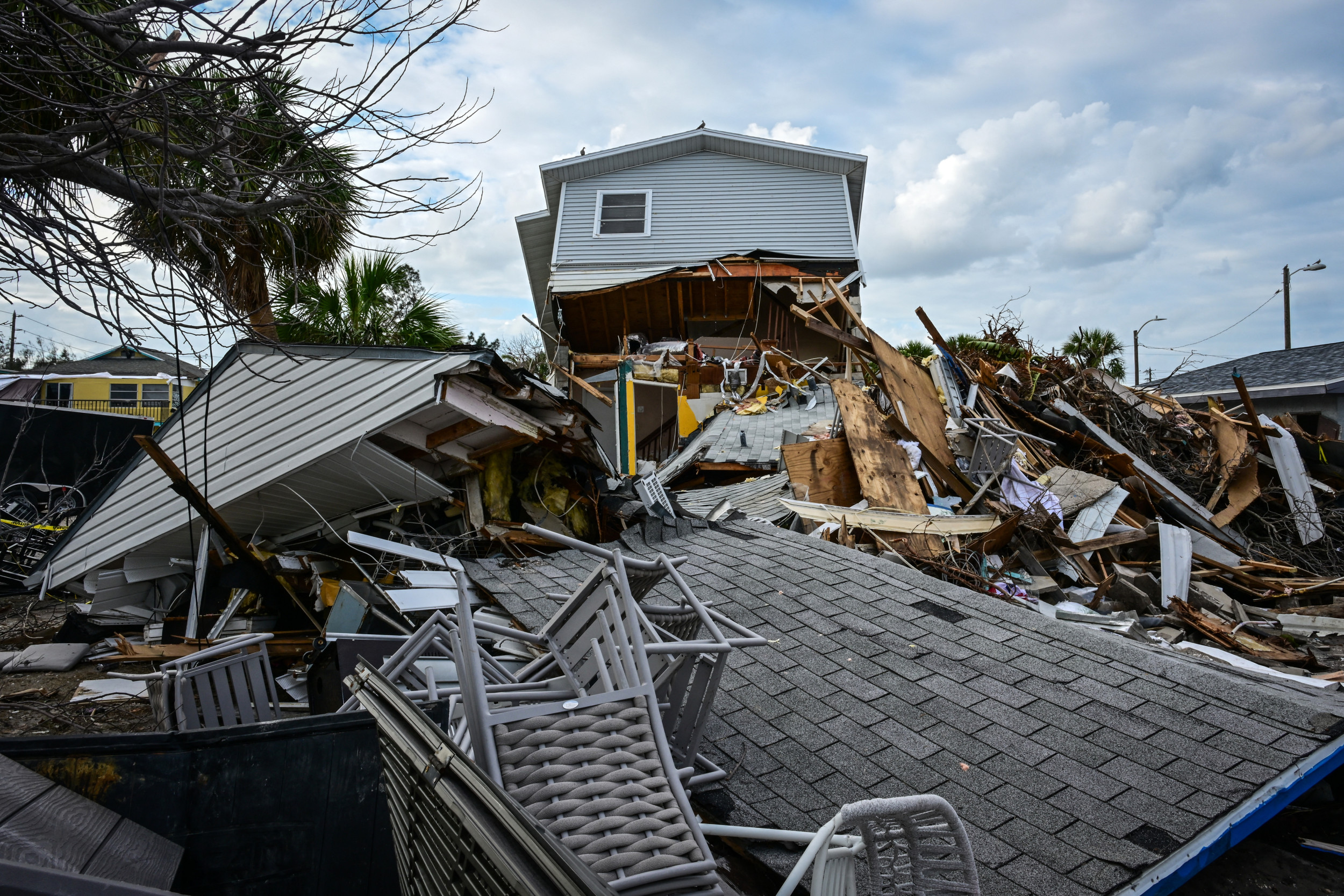
A destroyed home is seen in the aftermath of Hurricane Milton in St. Pete Beach, Florida, on October 11, 2024.
A destroyed home is seen in the aftermath of Hurricane Milton in St. Pete Beach, Florida, on October 11, 2024.
GIORGIO VIERA/AFP /AFP via Getty Images
Hurricanes are powerful tropical cyclones that begin as tropical storms once sustained winds reach 39 to 73 mph. These storms are named from a rotating list maintained by the World Meteorological Organization.
Once wind speeds exceed 74 mph, the system is classified as a hurricane and rated on the Saffir-Simpson Hurricane Wind Scale. This scale categorizes hurricanes from Category 1 to Category 5 based on sustained wind intensity:
Category 1: 74–95 mph (119–153 km/h)
Category 2: 96–110 mph (154–177 km/h)
Category 3: 111–129 mph (178–208 km/h)
Category 4: 130–156 mph (209–251 km/h)
Category 5: 157 mph or higher (252 km/h or higher)
While the scale focuses solely on wind speed, it helps estimate potential damage. Categories 3 and above are considered major hurricanes, often capable of causing devastating structural damage and prolonged power outages.
12:39 PM EDT
What is a Cabo Verde hurricane? Erin offers a timely example
Hurricane Erin is a textbook example of a Cabo Verde hurricane—a type of storm that forms near the Cabo Verde Islands off Africa’s west coast. These systems typically develop from clusters of thunderstorms drifting westward across the Atlantic.
Senior digital meteorologist Jonathan Erdman explains that while Cabo Verde hurricanes often gain strength over open water and attract early attention, many never pose a direct threat to the U.S. Their long journey across the Atlantic gives forecasters time to track and assess potential impacts.
Though powerful, these storms frequently curve northward or weaken before reaching land, making them more notable for their formation than their landfall risk. Erin’s development highlights the pattern, offering a clear case study of this Atlantic hurricane type.
12:24 PM EDT
Disturbance near Texas-Mexico border unlikely to develop
A tropical disturbance hovering near the northeastern coast of Mexico and southern Texas is losing its chance to form into a cyclone, according to the National Hurricane Center.
An Air Force Reserve Hurricane Hunter aircraft found no closed circulation within the system, and updated radar data shows the center is closer to land than previously thought. With only a few hours left over water, forecasters say the likelihood of development is diminishing.
Despite the low formation potential, forecasters warn that locally heavy rainfall could impact the region through Thursday.
Outlook Update 10AM CDT Aug 15: An Air Force Reserve Hurricane Hunter aircraft has been investigating the disturbance located along the coast of northeastern Mexico and southern Texas. Aircraft wind data and coastal radar data indicate that a closed circulation is not present… pic.twitter.com/qfTv2oVYYW
— National Hurricane Center (@NHC_Atlantic) August 15, 2025
12:06 PM EDT
How hurricanes form and intensify: A look at tropical cyclones
Hurricanes, typhoons, and tropical cyclones are all names for the same weather phenomenon: a rotating, low-pressure system with organized thunderstorm activity that forms over warm tropical or subtropical waters. These systems draw energy from the ocean’s heat and moisture, fueling their development and intensity.
Meteorologists classify tropical cyclones by wind speed:
Tropical depression: winds less than 39 mph
Tropical storm: winds between 39–73 mph
Hurricane: winds of 74 mph or higher
Major hurricane: winds of 111 mph or more
As a storm strengthens, it becomes more “organized,” meaning its thunderstorms begin to wrap around a central point, forming distinct bands. This structure signals the development of a closed circulation—winds rotating continuously around a center. In the Northern Hemisphere, this rotation is counterclockwise; in the Southern Hemisphere, it’s clockwise.
The hallmark of a mature hurricane is its eye—a calm, clear center surrounded by the eyewall, where the most intense winds occur. Satellite imagery often reveals this structure as storms intensify, as seen in past hurricanes like Ian and Michael.
These powerful systems can produce destructive winds, torrential rain, and coastal flooding. Their formation depends on a combination of warm ocean temperatures, moist air, and minimal wind shear. When these conditions align, tropical cyclones can rapidly escalate into major hurricanes capable of widespread damage.
11:54 AM EDT
Importance of hurricane prep
With the height of Atlantic hurricane season approaching, AccuWeather experts are urging residents to review evacuation plans, check emergency supplies, and confirm insurance coverage.
Historically, the first Atlantic hurricane forms around Aug. 11, with the first major hurricane typically arriving by Sept. 1. This year, forecasters are tracking two low-risk tropical waves in the Atlantic’s main development region, following the path of Tropical Rainstorm Erin. Cooler waters left by Erin may rebound quickly, creating favorable conditions for new storms later this month.
In the western Gulf of Mexico, a medium-risk area for tropical development could bring heavy rain to southern and central Texas. AccuWeather warns of flash flooding, especially in regions still recovering from July’s deadly floods in the Hill Country.
The 2025 forecast calls for 13 to 18 named storms, including up to five major hurricanes. AccuWeather expects three to six direct U.S. impacts, matching last year’s historic season. Officials and residents are advised to prepare for inland flooding and tornado risks following landfall.
11:41 AM EDT
Bermuda braces for wind, rain and rough seas as Hurricane Erin nears
Hurricane Erin is forecast to pass west of Bermuda next week, potentially bringing damaging winds, heavy rain, and hazardous marine conditions, according to AccuWeather experts.
Residents are being warned to prepare for wind gusts between 60 and 80 mph, with isolated peaks up to 100 mph. These conditions could down trees and disrupt power across the island. Rainfall totals are expected to reach 2 to 4 inches from Tuesday through Thursday, with localized amounts up to 8 inches.
Forecasters also caution that waves near Erin’s center could soar to 50–75 feet, generating dangerous rip currents and coastal flooding. Swells and surf hazards are likely even if the storm’s core remains offshore.
11:30 AM EDT
Hurricane Erin to brush Northern Caribbean, stir coastal hazards along U.S East Coast
Hurricane Erin is expected to pass roughly 200 miles north of Puerto Rico this weekend as a Category 3 storm, bringing heavy rain, gusty winds, and minor storm surge to parts of the northern Leeward Islands.
AccuWeather meteorologists warn that outer bands could trigger flash flooding and mudslides from Antigua and Barbuda through Puerto Rico. Winds may down trees and power lines, with localized power outages possible. Beaches across the region could see storm surge between 1 and 3 feet.
Erin currently ranks below one on the AccuWeather RealImpact™ Scale for Hurricanes in the Caribbean, indicating limited damage potential but some risk of coastal inundation.
Along the U.S. East Coast, forecasters urge vigilance as Erin strengthens and curves northward. While the storm is expected to remain offshore, rough surf and dangerous rip currents are likely from South Florida to Atlantic Canada. Waves up to 15 feet could cause beach erosion, especially in the Outer Banks.
A westward shift in Erin’s track, influenced by the Bermuda High and a cold front, could increase risks for eastern North Carolina, Long Island, and southeastern New England. However, current projections favor a northeast turn into the open Atlantic.
11:19 AM EDT
Erin’s strength may decide its path across the Atlantic
Tropical Storm Erin’s rate of intensification over the next few days could determine whether it curves north or continues west toward land. Forecasters say the storm is entering a region of unusually warm sea surface temperatures, which could fuel rapid growth into a major hurricane by Sunday.
If Erin strengthens quickly, its towering storm clouds may reach higher into the atmosphere and catch faster winds that steer it northward. A slower-developing storm would remain lower and be guided west by trade winds, potentially increasing the risk to Caribbean islands.
The Bermuda High, a dominant Atlantic pressure system, will also influence Erin’s track. Its position and strength could help pull the storm away from land—or allow it to drift closer. Officials urge communities in the storm’s potential path to prepare now, as its trajectory should become clearer by the weekend.
11:09 AM EDT
Erin poised to become first Atlantic hurricane of 2025
Tropical Storm Erin is expected to intensify into a Category 4 hurricane by Sunday, marking the Atlantic’s first hurricane of the season after a quiet start. The storm reached 70 mph sustained winds Thursday evening while moving west-northwest over open waters, according to the National Hurricane Center.
Erin is forecast to pass just north of the Leeward Islands, Virgin Islands, and Puerto Rico this weekend, prompting tropical storm watches across parts of the northeastern Caribbean. While a direct landfall is unlikely, gusty winds, heavy rain, and dangerous surf could impact the region, with flash flooding and mudslides possible.
The Atlantic hurricane season is running slightly behind schedule. Erin follows four earlier systems—Andrea, Barry, Chantal, and Dexter—that failed to reach hurricane strength. Forecasters say it’s too early to determine whether Bermuda or the U.S. East Coast will see direct impacts, but rough seas and rip currents are expected into next week.