
As of late Sunday, Erin is a category 3 hurricane with maximum sustained winds of 125 mph. Erin is moving west-northwest at 13 mph with a pressure back up to 946 millibars, indicating Erin has weakened slightly due to some structural changes and eyewall replacement cycles. Erin is forecast to strengthen again within the next 24-48 hours as it encounters warm sea surface temperatures. The Hurricane Hunters will fly into Erin again this evening to see if the storm has intensified and if wind speeds have increased. Latest Tropical AdvisoryHere is a link to the NHC advisory in English and Spanish. The storm is about 150 miles north of San Juan, Puerto Rico.Tropical TrackTropical Spaghetti ModelsErin rapidly intensified into a category 5 major hurricane late Saturday morning. Erin is one of the fastest-growing storms on record. Its sustained winds increased from 75 mph on Friday morning to l60 mph by Saturday morning. More category 5 storms like Erin that jump up several categories in a short time are expected according to NASA scientists due to warming planetary conditions.Sea Surface TemperaturesErin’s Track This WeekAlthough Erin may never make landfall, there will be coastal impacts over a widespread area from the The Bahamas and the entire U.S. East Coast. Bermuda may have substantial impacts from wind, rain and surf. The island nation will be the closest landmass to the most dangerous part of the storm. Residents along the East Coast and Bermuda will want to watch for possible track adjustments early this week that may lead to more significant coastal impactsA more northerly track is expected to occur on Sunday and Monday as steering currents lift Erin between the U.S. East Coast and Bermuda. If the storm remains on the current forecast track, Bermuda may receive more direct impacts. Even as Erin is expected to pass hundreds of miles offshore, high surf and dangerous rip currents are expected at the North Carolina beaches Tuesday through Thursday as Erin approaches and passes off the coast. People visiting or living in the Outer Banks should pay especially close attention to Erin’s progress up the East Coast as overwash, coastal erosion and high surf may become an issue along Highway 12.A look back at Hurricane Erin as a Category 5Slideshows: Tropical Satellite Images and Looping Satellite Five Named Storms So Far This SeasonThere have been a total of five named storms in the 2025 season to date. Andrea, Barry and Chantal formed earlier this season, and Dexter formed in early August. Chantal was the storm that brought devastating flash flooding to parts of central North Carolina and claimed the lives of five people in the state. Chantal formed over the July Fourth weekend and dissipated on July 6. Erin formed during the second week of August on Monday, Aug. 11 at 11 a.m. From a category 2 hurricane on Saturday morning at 2 a.m. Hurricane Erin became a major category 4 hurricane in just six hours. Shortly after 11 a.m. Hurricane Hunters discovered Erin had become a category 5 hurricane.Related CoverageLanie Pope explains Helene’s massive flooding, why it was potentially a 100-year flood event for the state in the interactive video featured below:It’s the worst of the worst to ever hit North Carolina, as Dylan Hudler explains the names our state will never forget in the interactive video featured below:More weather coverage: Weather Alerts | Latest weather forecast | Post pictures to the uLocal North Carolina Facebook Group | Traffic information | Report closings and delays | SkyCams | Download the WXII 12 News mobile app
WINSTON-SALEM, N.C. —
As of late Sunday, Erin is a category 3 hurricane with maximum sustained winds of 125 mph. Erin is moving west-northwest at 13 mph with a pressure back up to 946 millibars, indicating Erin has weakened slightly due to some structural changes and eyewall replacement cycles. Erin is forecast to strengthen again within the next 24-48 hours as it encounters warm sea surface temperatures. The Hurricane Hunters will fly into Erin again this evening to see if the storm has intensified and if wind speeds have increased.
This content is imported from Facebook.
You may be able to find the same content in another format, or you may be able to find more information, at their web site.
Latest Tropical Advisory

Here is a link to the NHC advisory in English and Spanish. The storm is about 150 miles north of San Juan, Puerto Rico.
Tropical Track

Hearst OwnedWXII 12 Weather
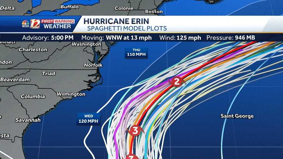
Tropical Spaghetti Models

Hearst OwnedWXII 12 Weather
Erin rapidly intensified into a category 5 major hurricane late Saturday morning. Erin is one of the fastest-growing storms on record. Its sustained winds increased from 75 mph on Friday morning to l60 mph by Saturday morning. More category 5 storms like Erin that jump up several categories in a short time are expected according to NASA scientists due to warming planetary conditions.
Sea Surface Temperatures

Erin’s Track This Week
Although Erin may never make landfall, there will be coastal impacts over a widespread area from the The Bahamas and the entire U.S. East Coast. Bermuda may have substantial impacts from wind, rain and surf. The island nation will be the closest landmass to the most dangerous part of the storm. Residents along the East Coast and Bermuda will want to watch for possible track adjustments early this week that may lead to more significant coastal impacts
This content is imported from Facebook.
You may be able to find the same content in another format, or you may be able to find more information, at their web site.
A more northerly track is expected to occur on Sunday and Monday as steering currents lift Erin between the U.S. East Coast and Bermuda. If the storm remains on the current forecast track, Bermuda may receive more direct impacts. Even as Erin is expected to pass hundreds of miles offshore, high surf and dangerous rip currents are expected at the North Carolina beaches Tuesday through Thursday as Erin approaches and passes off the coast. People visiting or living in the Outer Banks should pay especially close attention to Erin’s progress up the East Coast as overwash, coastal erosion and high surf may become an issue along Highway 12.
This content is imported from Facebook.
You may be able to find the same content in another format, or you may be able to find more information, at their web site.
A look back at Hurricane Erin as a Category 5
This content is imported from Facebook.
You may be able to find the same content in another format, or you may be able to find more information, at their web site.
Slideshows: Tropical Satellite Images and Looping Satellite
1 of 19
Tropical Advisory: Erin
This image has the latest details on Erin as the storm travels westward over the Atlantic Ocean.
PHOTO: WXII 12 News
2 of 19
Tropical Track: Erin
This image shows the current National Hurricane Center official forecast track for Erin.
PHOTO: WXII 12 Weather
3 of 19
Tropical Spaghetti Model Plots:Erin
This image shows various forecast models and projected storm tracks for Erin as the system moves westward toward the U.S. coast.
PHOTO: WXII 12 Weather
4 of 19
Eastern Antilles and Windward Islands Wind Gust Speeds in Miles Per Hour
This image shows recent wind gusts in miles per hour over the Lesser Antilles and the Eastern Atlantic Ocean. Ocean buoy data is also included.
5 of 19
Central Caribbean Wind Gust Speeds in Miles Per Hour
This image shows recent wind gusts in miles per hour over the Central Caribbean and the Windward Islands.
6 of 19
Tropical Alerts: Erin
Tropical alerts are in place as Erin moves westward in the Atlantic Ocean.
7 of 19
Tropical Wave Height Forecast in the Atlantic Ocean
This image shows wave height estimates as Erin moves westward in the Atlantic Ocean.
8 of 19
This image shows current sea surface temperature in the Atlantic, Caribbean and Gulf using degrees Fahrenheit.
9 of 19
Tropical Wave Invest 98-L
This area of interest in the Gulf may become a depression before drifting toward the Texas coast.
10 of 19
Tropical Area of Interest in the Gulf Spaghetti Model Plots
This image shows a tropical wave known as Invest 96-L.
11 of 19
Yucatan Wind Gust Speeds in Miles Per Hour
This image shows wind gust speed in miles per hour for the Yucatan Peninsula, the Gulf, and Texas. Satellite imagery shows cloud cover and any precipitation along the Gulf Coast through Cuba.
12 of 19
Tropical System Categorie Based on Storm Wind Speeds
This chart shows the level of wind speeds needed to be categorized as a tropical system.
PHOTO: WXII 12 News
13 of 19
Estimated Wave Height Along the Coast of North Carolina
This image shows the estimated wave height along the coastal regions of North Carolina.
14 of 19
http://www.wxii12.com/article/tracking-tropical-development-hurricane-maps-images/65293562
15 of 19
Georgia and the Carolinas Wind Gust Speed & Radar
This image show rain, lightning strikes and wind gust speed in miles per hour from Georgia toward North Carolina.
16 of 19
Florida to North Carolina Wind Gust Speeds in Miles Per Hour
This image shows wind gust speed in miles per hour from Florida to North Carolina. Satellite imagery shows cloud cover and any precipitation along the East Coast through the Outer Banks.
17 of 19
Southeast Wind Gust Speed in Miles Per Hour
This is an image of radar and wind gust speed displayed in miles per hour for the Southeast United States and the Gulf.
18 of 19
North Carolina Rainfall During Chantal
19 of 19
2024: Hurricane Helene’s Category 4 Landfall Over Florida
Hurricane Helene’s Category 4 Landfall in the Big Bend Area of Florida on September 26 at 11:10 p.m.
PHOTO: WXII 12 Weather
1 of 15
Enhanced Infrared Satellite Imagery of Erin in the Atlantic
2 of 15
Tropical Track: Erin
PHOTO: WXII 12 Weather
3 of 15
Wave Height Forecast and Erin’s Tropical Track
4 of 15
Tropical Cyclone Heat Potential
This image shows the warmer waters near the Leeward Islands and Puerto Rico in the warmer colors. Deeper layers of warm ocean water provide fuel for tropical development and intensification of storms.
5 of 15
Sea Surface Water Temperature in the Atlantic
6 of 15
Wind Gust Speed in Miles Per Hour: Eastern Antilles
7 of 15
Wind Gust Speed in Miles Per Hour: Puerto Rico and the Antilles
8 of 15
Tropical Atlantic Infrared Satellite
9 of 15
Radar and Wind Gust Speed in Miles Per Hour: North Carolina Coast
10 of 15
Radar, Satellite, and Wind Gust Speed in Miles Per Hour: South Carolina and North Carolina
11 of 15
Southeast: Rainfall Intensity and Wind Gust Speed in Miles Per Hour
12 of 15
Georgia and South Carolina: Rainfall Intensity and Wind Gust Speed in Miles Per Hour
13 of 15
The Bahamas: Rainfall Intensity and Wind Gust Speed in Miles Per Hour
14 of 15
Florida and The Bahamas: Rainfall Intensity and Wind Gust Speed in Miles Per Hour
15 of 15
Tropical West Africa Infrared Satellite Imagery
Five Named Storms So Far This Season
There have been a total of five named storms in the 2025 season to date. Andrea, Barry and Chantal formed earlier this season, and Dexter formed in early August. Chantal was the storm that brought devastating flash flooding to parts of central North Carolina and claimed the lives of five people in the state. Chantal formed over the July Fourth weekend and dissipated on July 6.
Erin formed during the second week of August on Monday, Aug. 11 at 11 a.m. From a category 2 hurricane on Saturday morning at 2 a.m. Hurricane Erin became a major category 4 hurricane in just six hours. Shortly after 11 a.m. Hurricane Hunters discovered Erin had become a category 5 hurricane.
Lanie Pope explains Helene’s massive flooding, why it was potentially a 100-year flood event for the state in the interactive video featured below:
It’s the worst of the worst to ever hit North Carolina, as Dylan Hudler explains the names our state will never forget in the interactive video featured below:
More weather coverage: Weather Alerts | Latest weather forecast | Post pictures to the uLocal North Carolina Facebook Group | Traffic information | Report closings and delays | SkyCams | Download the WXII 12 News mobile app