Red flags are flying on North Carolina beaches— warning swimmers not to get in the water. Hurricane Erin is several hundred miles away from Hatteras Island, but its large wind field is helping amplify wave heights even before it tracks parallel to the North Carolina coast on Thursday. Waves 10-20 feet high will impact the coast this week. But what does that mean for your beach trip this weekend? Keep reading for your beach forecast through the end of this week; you can find details at the end of this article.Large swells, marine alerts and life-threatening rip currents are developing at North Carolina beachesThe dream of catching the “big wave” right off the coast of North Carolina may draw a lot of surfers to the beach, but it also means lifeguards and emergency personnel will be on high alert. There have been several water rescues reported at the Southern beaches in North Carolina since Monday. Emerald Isle: Bogue Inlet Pier CamNational Weather Service (NWS) meteorologists issued a tropical storm warning and storm surge warning for coastal communities in North Carolina. Strong winds and flooding are possible when Hurricane Erin approaches during the next few days.Beach Hazards AlertsHurricane Erin and Current Wind Gust SpeedHurricane Erin’s Track and Wave Height ForecastCurrent Wave HeightGeorgia and the Carolinas: Wind Gust Speed in Miles Per HourRead our current article here for more details on Hurricane Erin and find the beach forecast below.A State of Emergency has been issued in Dare County due to Erin’s proximity to North Carolina. Find out more about it here.Water Rescues Reported at North Carolina Beaches in Advance of ErinBeach hazards in North Carolina this weekThe National Weather Service meteorologists in Morehead City are forecasting the threat of beach hazards including high surf and rip currents beginning Tuesday for the Northern Outer Banks and Crystal Coast beaches.Rip currents pull swimmers out to sea and away from the beachFor rip current safety, remember to stay calm and swim parallel to the shore instead of fighting the rip, swim out of it.Strong longshore currents may form during Erin’s approach and after the Erin pulls away on Thursday into Friday.The longshore current is in the surf zone and can sweep swimmers and surfers into rip currents, piers, jetties and other hazardous areas.Swimmers can be swept miles away down the beach from their entry point in the surf.The strength of the current may prevent swimmers from being able to keep their feet on the bottom, making it difficult for them to return to shore.Try to stand and walk perpendicular to the longshore current to get out of the impact zone and back on dry beach.You can find more beach forecast details on the Experimental Beach Forecast Page for East Coast beaches here. Tidal and current information can be found here too.Rip currents are active along the southern beaches in North Carolina and northern beaches in South Carolina, and threats continue to roll up the coast as Hurricane Erin displaces water and creates large swells. For more on other beach hazards and what to watch for at the coast, check out endurance athlete and professional waterman, Bruckner Chase’s video about shorebreak waves and how to prepare for a day at the beach on Blue IQ .Here’s a helpful video to understand ocean currents before you get in the water.NOAA’s Blue IQ: Staying Safe in Ocean Currents with Bruckner ChaseNOAA’s Break the Grip of the Rip Ocean VideoMeteorologist Dylan Hudler has more on rip current safety Southern Beaches: Carolina Beach, Myrtle Beach, Pawley’s Island, Wrightsville BeachCrystal Coast: Atlantic Beach, Emerald Isle, Salter PathOuter Banks: Corolla, Nags Head, Hatteras More weather coverage: Weather Alerts | Latest weather forecast | Post pictures to the uLocal North Carolina Facebook Group | Traffic information | Report closings and delays | SkyCams | Download the WXII12 News mobile app
WINSTON-SALEM, N.C. —
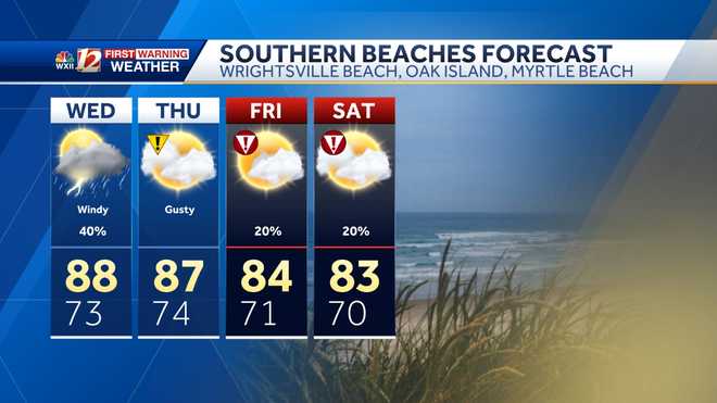
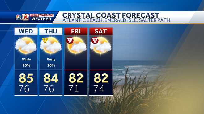
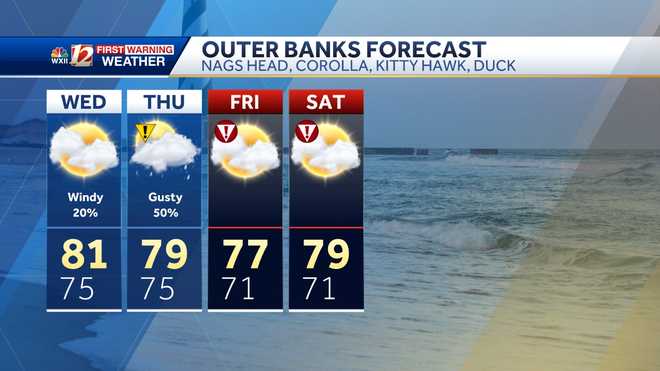
Red flags are flying on North Carolina beaches— warning swimmers not to get in the water. Hurricane Erin is several hundred miles away from Hatteras Island, but its large wind field is helping amplify wave heights even before it tracks parallel to the North Carolina coast on Thursday. Waves 10-20 feet high will impact the coast this week. But what does that mean for your beach trip this weekend? Keep reading for your beach forecast through the end of this week; you can find details at the end of this article.
Large swells, marine alerts and life-threatening rip currents are developing at North Carolina beaches
The dream of catching the “big wave” right off the coast of North Carolina may draw a lot of surfers to the beach, but it also means lifeguards and emergency personnel will be on high alert. There have been several water rescues reported at the Southern beaches in North Carolina since Monday.
Emerald Isle: Bogue Inlet Pier Cam
This content is imported from YouTube.
You may be able to find the same content in another format, or you may be able to find more information, at their web site.
This content is imported from Facebook.
You may be able to find the same content in another format, or you may be able to find more information, at their web site.
National Weather Service (NWS) meteorologists issued a tropical storm warning and storm surge warning for coastal communities in North Carolina. Strong winds and flooding are possible when Hurricane Erin approaches during the next few days.
This content is imported from Facebook.
You may be able to find the same content in another format, or you may be able to find more information, at their web site.
Beach Hazards Alerts
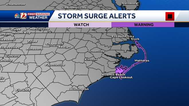
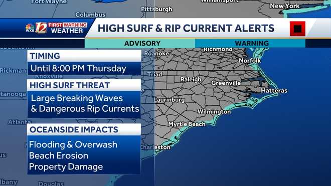
Hurricane Erin and Current Wind Gust Speed

Hurricane Erin’s Track and Wave Height Forecast
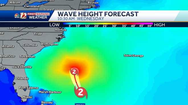
Current Wave Height
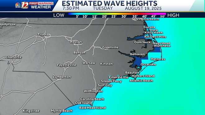
Georgia and the Carolinas: Wind Gust Speed in Miles Per Hour

Read our current article here for more details on Hurricane Erin and find the beach forecast below.
A State of Emergency has been issued in Dare County due to Erin’s proximity to North Carolina. Find out more about it here.
Water Rescues Reported at North Carolina Beaches in Advance of Erin
Beach hazards in North Carolina this week
The National Weather Service meteorologists in Morehead City are forecasting the threat of beach hazards including high surf and rip currents beginning Tuesday for the Northern Outer Banks and Crystal Coast beaches.
Rip currents pull swimmers out to sea and away from the beachFor rip current safety, remember to stay calm and swim parallel to the shore instead of fighting the rip, swim out of it.
Strong longshore currents may form during Erin’s approach and after the Erin pulls away on Thursday into Friday.
The longshore current is in the surf zone and can sweep swimmers and surfers into rip currents, piers, jetties and other hazardous areas.Swimmers can be swept miles away down the beach from their entry point in the surf.The strength of the current may prevent swimmers from being able to keep their feet on the bottom, making it difficult for them to return to shore.Try to stand and walk perpendicular to the longshore current to get out of the impact zone and back on dry beach.
You can find more beach forecast details on the Experimental Beach Forecast Page for East Coast beaches here. Tidal and current information can be found here too.
Rip currents are active along the southern beaches in North Carolina and northern beaches in South Carolina, and threats continue to roll up the coast as Hurricane Erin displaces water and creates large swells. For more on other beach hazards and what to watch for at the coast, check out endurance athlete and professional waterman, Bruckner Chase’s video about shorebreak waves and how to prepare for a day at the beach on Blue IQ .
Here’s a helpful video to understand ocean currents before you get in the water.
NOAA’s Blue IQ: Staying Safe in Ocean Currents with Bruckner Chase
NOAA’s Break the Grip of the Rip Ocean Video
This content is imported from YouTube.
You may be able to find the same content in another format, or you may be able to find more information, at their web site.
Meteorologist Dylan Hudler has more on rip current safety
Southern Beaches: Carolina Beach, Myrtle Beach, Pawley’s Island, Wrightsville Beach
Crystal Coast: Atlantic Beach, Emerald Isle, Salter Path
Outer Banks: Corolla, Nags Head, Hatteras
More weather coverage: Weather Alerts | Latest weather forecast | Post pictures to the uLocal North Carolina Facebook Group | Traffic information | Report closings and delays | SkyCams | Download the WXII12 News mobile app

