
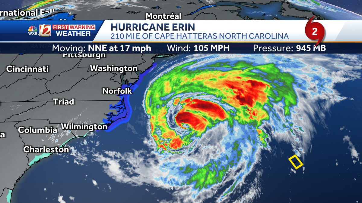
Hurricane Erin is now more than 290 miles off the North Carolina coast Thursday afternoon. There are storm surge and tropical storm warnings up and down the Carolina coast for remaining storm surge and beach hazards from Erin’s big waves. For current conditions and loops of radar near the coast, please check out the maps below.Storm surge forecast to peak tonight in the northern Outer BanksFrequent and strong waves have been recorded along the coast as Erin begins to move further offshore; these long period swells will create storm surge flooding compounded by high tide and beach erosion. The storm is speeding up, and moving away from the United States. Strong waves and rip currents will still be a concern after Hurricane Erin’s rain stop at the coast. Check out the forecast and specific details for the Outer Banks provided by teh meteorologists at the National Weather Service in Morehead City.Hurricane Erin may set several records, one for its rapid intensification on Saturday and another for its large size and expansive wind field that has been bigger than the state of Texas and wider than the state of North Carolina. Tropical advisory and trackThe official track from National Hurricane Center meteorologists keeps Erin moving northeasterly into the Northern Atlantic Ocean. The largest wind field is found in the storms northeast quadrant. Here is a link to the NHC advisory in English and Spanish. Coastal flooding is likely to be the biggest problem for residents and beach goers in the Outer Banks through tonight as storm surge is expected to reach its peak during high tides. The max wind gusts from Erin are ranging from 56 mph at Jennette’s Pier in Nags Head to 49 mph in Oregon Inlet in the Northern Outer Banks.Tropical forecast coneTropical spaghetti modelsRadar and current wind gust speed in miles per hourMaximum wind gust speed in the Piedmont Triad TodayOcean buoy wave heights during the last few hours Current Ocean buoy wave heights Current ocean buoy wind gust speed in miles per hour in the Mid-AtlanticTropical storm alerts in North CarolinaA tropical storm warning and storm surge warning are in effect for parts of the North Carolina Coast. There is a danger of life-threatening flooding. High waves at the coast may cause inundation of coastal communities, as well as flooding of low-lying areas inland. A State of Emergency has been issued for Dare County in North Carolina, and mandatory evacuation of Hatteras Island was ordered. Highway 12 may remained closed in spots as overwash and flooding continues. Even as Erin is pulling away from North Carolina, high surf and dangerous rip currents are expected at North Carolina’s Outer Banks beaches through Friday. Red flags were flying in Atlantic Beach and water covered roads were reported there early Thursday.Ron Fisher shared this video from the coast before the stormSlideshows: Tropical Satellite Images and Looping SatelliteFive Named Storms So Far This SeasonSo far for the 2025 Atlantic Hurricane Season, there is a total of five named storms. Andrea, Barry and Chantal formed earlier this season, and Dexter formed in early August. Chantal was the storm that brought devastating flash flooding to parts of central North Carolina and claimed the lives of five people in the state. Chantal formed over the July Fourth weekend and dissipated on July 6.Erin formed during the second week of August on Monday, Aug. 11. Erin became a hurricane early Saturday morning, and then a major Category 4 hurricane in just six hours. Shortly after 11 a.m. Saturday, Hurricane Hunters discovered Erin had become a Category 5 hurricane.Erin is one of the fastest-growing storms on record. Its sustained winds increased from 75 mph on the morning of Friday July 15 to 160 mph by Saturday morning. Category 5 storms like Erin that jump up several categories in a short time are more likely now, according to NASA scientists, due to warming planetary conditions.Related CoverageLanie Pope explains Helene’s massive flooding, why it was potentially a 100-year flood event for the state in the interactive video featured below:Helene is the worst of the worst to ever hit North Carolina, as Dylan Hudler explains the names our state will never forget in the interactive video featured below:More weather coverage: Weather Alerts | Closing and delays | Latest weather forecast | Post pictures to the uLocal North Carolina Facebook Group | Traffic information | Report closings and delays | SkyCams | Download the WXII12 News mobile app
WINSTON-SALEM, N.C. —
Hurricane Erin is now more than 290 miles off the North Carolina coast Thursday afternoon. There are storm surge and tropical storm warnings up and down the Carolina coast for remaining storm surge and beach hazards from Erin’s big waves. For current conditions and loops of radar near the coast, please check out the maps below.
Storm surge forecast to peak tonight in the northern Outer Banks
Frequent and strong waves have been recorded along the coast as Erin begins to move further offshore; these long period swells will create storm surge flooding compounded by high tide and beach erosion. The storm is speeding up, and moving away from the United States. Strong waves and rip currents will still be a concern after Hurricane Erin’s rain stop at the coast. Check out the forecast and specific details for the Outer Banks provided by teh meteorologists at the National Weather Service in Morehead City.
This content is imported from Facebook.
You may be able to find the same content in another format, or you may be able to find more information, at their web site.
This content is imported from Facebook.
You may be able to find the same content in another format, or you may be able to find more information, at their web site.
Hurricane Erin may set several records, one for its rapid intensification on Saturday and another for its large size and expansive wind field that has been bigger than the state of Texas and wider than the state of North Carolina.
Tropical advisory and track
This content is imported from Facebook.
You may be able to find the same content in another format, or you may be able to find more information, at their web site.
The official track from National Hurricane Center meteorologists keeps Erin moving northeasterly into the Northern Atlantic Ocean. The largest wind field is found in the storms northeast quadrant. Here is a link to the NHC advisory in English and Spanish.

Hearst OwnedWXII 12 Weather

Hearst OwnedWXII 12 Weather
Coastal flooding is likely to be the biggest problem for residents and beach goers in the Outer Banks through tonight as storm surge is expected to reach its peak during high tides. The max wind gusts from Erin are ranging from 56 mph at Jennette’s Pier in Nags Head to 49 mph in Oregon Inlet in the Northern Outer Banks.

Tropical forecast cone
Hearst OwnedWXII 12 Weather
Tropical spaghetti models

Hearst OwnedWXII 12 Weather
Radar and current wind gust speed in miles per hour


Maximum wind gust speed in the Piedmont Triad Today

Ocean buoy wave heights during the last few hours

Current Ocean buoy wave heights

Current ocean buoy wind gust speed in miles per hour in the Mid-Atlantic

Tropical storm alerts in North Carolina
A tropical storm warning and storm surge warning are in effect for parts of the North Carolina Coast. There is a danger of life-threatening flooding. High waves at the coast may cause inundation of coastal communities, as well as flooding of low-lying areas inland.
A State of Emergency has been issued for Dare County in North Carolina, and mandatory evacuation of Hatteras Island was ordered. Highway 12 may remained closed in spots as overwash and flooding continues.
Even as Erin is pulling away from North Carolina, high surf and dangerous rip currents are expected at North Carolina’s Outer Banks beaches through Friday. Red flags were flying in Atlantic Beach and water covered roads were reported there early Thursday.
Ron Fisher shared this video from the coast before the storm
Slideshows: Tropical Satellite Images and Looping Satellite
1 of 20
Tropical Advisory: Hurricane Erin
This image has the latest details on Erin as the storm travels westward over the Atlantic Ocean.
PHOTO: WXII 12 News
2 of 20
Tropical Track: Hurricane Erin
This image shows the current National Hurricane Center official forecast track for Erin.
PHOTO: WXII 12 Weather
3 of 20
Tropical Infrared Satellite Imagery: Hurricane Erin
Tropical Infrared Satellite Imagery: Hurricane Erin
4 of 20
Wind Gust Speed in Miles Per Hour: Hurricane Erin
This image shows ocean buoy data and wind gust speed recorded by automated weather sites during Hurricane Erin’s approach to the North Carolina coast.
5 of 20
Wind Gust Speed Forecast for Thursday in Miles Per Hour: North Carolina During Hurricane Erin
This image shows possible wind gust speeds for Thursday due to Hurricane Erin.
6 of 20
Peak Storm Surge Potential
This image depicts the risk of storm surge in feet along the North Carolina coast.
7 of 20
Tropical Spaghetti Model Plots:Hurricane Erin
This image shows various forecast models and projected storm tracks for Erin as the system moves westward toward the U.S. coast.
PHOTO: WXII 12 Weather
8 of 20
Estimated Wave Height Along the Coast of North Carolina
This image shows the estimated wave height along the coastal regions of North Carolina.
9 of 20
This image shows current sea surface temperature in the Atlantic, Caribbean and Gulf using degrees Fahrenheit.
10 of 20
Georgia and the Carolinas Wind Gust Speed & Radar
This image show rain, lightning strikes and wind gust speed in miles per hour from Georgia toward North Carolina.
11 of 20
http://www.wxii12.com/article/tracking-tropical-development-hurricane-maps-images/65293562
12 of 20
Tropical System Categorie Based on Storm Wind Speeds
This chart shows the level of wind speeds needed to be categorized as a tropical system.
PHOTO: WXII 12 News
13 of 20
Florida to North Carolina Wind Gust Speeds in Miles Per Hour
This image shows wind gust speed in miles per hour from Florida to North Carolina. Satellite imagery shows cloud cover and any precipitation along the East Coast through the Outer Banks.
14 of 20
Tropical Alerts: Erin
Tropical alerts are in place as Erin moves westward in the Atlantic Ocean.
15 of 20
Eastern Antilles and Windward Islands Wind Gust Speeds in Miles Per Hour
This image shows recent wind gusts in miles per hour over the Lesser Antilles and the Eastern Atlantic Ocean. Ocean buoy data is also included.
16 of 20
Central Caribbean Wind Gust Speeds in Miles Per Hour
This image shows recent wind gusts in miles per hour over the Central Caribbean and the Windward Islands.
17 of 20
Yucatan Wind Gust Speeds in Miles Per Hour
This image shows wind gust speed in miles per hour for the Yucatan Peninsula, the Gulf, and Texas. Satellite imagery shows cloud cover and any precipitation along the Gulf Coast through Cuba.
18 of 20
Southeast Wind Gust Speed in Miles Per Hour
This is an image of radar and wind gust speed displayed in miles per hour for the Southeast United States and the Gulf.
19 of 20
North Carolina Rainfall During Chantal
20 of 20
2024: Hurricane Helene’s Category 4 Landfall Over Florida
Hurricane Helene’s Category 4 Landfall in the Big Bend Area of Florida on September 26 at 11:10 p.m.
PHOTO: WXII 12 Weather
1 of 18
Tropical Track: Erin
PHOTO: WXII 12 Weather
2 of 18
Tropical Probability of Wind Gusts of 39 mph
This loop shows Hurricane Erni’s probability of producing tropical storm force winds of 39 mph during the next 48 hours.
3 of 18
Wind Gust Speed Forecast in Miles Per Hour: Hurricane Erin
This loop shows the anticipated wind gust speed for locations in North Carolina during the next 48 hours as Hurricane Erin moves parallel to the East Coast.
4 of 18
Enhanced Infrared Satellite Imagery of Erin in the Atlantic
This loop shows the most recent satellite loops of Hurricane Ern in the Atlantic Ocean.
5 of 18
Wave Height Forecast and Erin’s Tropical Track
6 of 18
Tropical Infrared Satellite
7 of 18
Sea Surface Water Temperature in the Atlantic
9 of 18
Wind Gust Speed in Miles Per Hour: Eastern Antilles
10 of 18
Wind Gust Speed in Miles Per Hour: Puerto Rico and the Antilles
11 of 18
Radar and Wind Gust Speed in Miles Per Hour: North Carolina Coast
12 of 18
Radar, Satellite, and Wind Gust Speed in Miles Per Hour: South Carolina and North Carolina
13 of 18
Georgia and South Carolina: Rainfall Intensity and Wind Gust Speed in Miles Per Hour
14 of 18
Southeast: Rainfall Intensity and Wind Gust Speed in Miles Per Hour
15 of 18
Tropical Atlantic Infrared Satellite
16 of 18
Florida and The Bahamas: Rainfall Intensity and Wind Gust Speed in Miles Per Hour
17 of 18
Tropical West Africa Infrared Satellite Imagery
18 of 18
The Bahamas: Rainfall Intensity and Wind Gust Speed in Miles Per Hour
Five Named Storms So Far This Season
So far for the 2025 Atlantic Hurricane Season, there is a total of five named storms. Andrea, Barry and Chantal formed earlier this season, and Dexter formed in early August. Chantal was the storm that brought devastating flash flooding to parts of central North Carolina and claimed the lives of five people in the state. Chantal formed over the July Fourth weekend and dissipated on July 6.
Erin formed during the second week of August on Monday, Aug. 11. Erin became a hurricane early Saturday morning, and then a major Category 4 hurricane in just six hours. Shortly after 11 a.m. Saturday, Hurricane Hunters discovered Erin had become a Category 5 hurricane.

Erin is one of the fastest-growing storms on record. Its sustained winds increased from 75 mph on the morning of Friday July 15 to 160 mph by Saturday morning. Category 5 storms like Erin that jump up several categories in a short time are more likely now, according to NASA scientists, due to warming planetary conditions.
Related Coverage
Lanie Pope explains Helene’s massive flooding, why it was potentially a 100-year flood event for the state in the interactive video featured below:
Helene is the worst of the worst to ever hit North Carolina, as Dylan Hudler explains the names our state will never forget in the interactive video featured below:
More weather coverage: Weather Alerts | Closing and delays | Latest weather forecast | Post pictures to the uLocal North Carolina Facebook Group | Traffic information | Report closings and delays | SkyCams | Download the WXII12 News mobile app