
As Hurricane Gabrielle moves toward the Azores this week, we refocus our attention on two tropical waves that have a great chance of becoming the next named storms on the 2025 tropical cyclone list; Humberto and Imelda could form within the next seven days as they move northwest toward the U.S. Southeast Coast. Twin Tropical Waves in the Atlantic and CaribbeanThe lull in tropical activity and rain chances will come to an end simultaneously for North Carolina as a series of weather disturbances roll in from the west, and the two tropical waves begin strengthening near the East Coast. Tropical Wind Gust Speeds in the Antilles and CaribbeanThe tropical wave with the greatest potential impact near or along the North Carolina Coast early next week is known as Invest 94-L. This tropical wave has an 80% chance of development within the next week. First, the wave is expected to bring scattered heavy rain and storms to the Northern Leeward Islands, Puerto Rico and the U.S. Virgin Islands this week. Development of this tropical wave is expected to happen near the Bahamas as the storm drops its forward speed from its current pace of 15-20 mph. Invest 94-L could become a depression later this week or weekendWhile Invest 94-L has the best chance of impacting the Southeast U.S., the other tropical wave just to the east may become a depression sooner. The tropical wave east of the Lesser Antilles is known as Invest 93-L. It has a 90% chance of development within the next couple of days and is farther east in the Atlantic on a similar track to Gabrielle. The developing system may transition to Humberto or Imelda depending on whether the other tropical wave intensifies faster. Invest 93-L is currently on a path that could be a threat for Bermuda residents and potentially North Carolina. Tropical wave Invest 93-L is becoming better organizedSpaghetti Model Plots for Potential Tropical DevelopmentTropical SlideshowsAre you ready for tropical impacts in North Carolina? The historically busiest tropical months still lie ahead. The 2025 Atlantic hurricane season continues through Nov. 30.Piedmont Triad residents can stay alert, informed and prepared by following these tips:Know your evacuation routes and have an emergency plan.Monitor the forecasts on WXII 12 News or WXII12.com.Review insurance coverage and protect important documents, especially in light of past flooding events like Helene (2024) and Chantal (2025).Have an emergency preparedness kit: water, batteries, flashlights and medications in case of power loss.WXII INTERACTIVE STUDIO: EXPLORE MORELanie Pope explains Helene’s massive flooding, why it was potentially a 100-year flood event for the state in the interactive video featured below:It’s the worst of the worst to ever hit North Carolina, as Dylan Hudler explains the names our state will never forget in the interactive video featured below:It’s not just the coast that gets hit with devastating impacts from hurricanes, as Brian Slocum explains, why monster storms leave lasting impacts in the interactive video featured below:Hurricane Hugo brought massive devastation to the Carolinas, as Dave Aiken explains with an in-depth look at the disastrous storm in the interactive video featured below.Find out the best ways to prepare for hurricane season as Michelle Kennedy explains what you can do now instead of waiting to do later in the interactive video featured below:More weather coverage: Weather Alerts | Closing and delays | Latest weather forecast | Post pictures to the uLocal North Carolina Facebook Group | Traffic information | Report closings and delays | SkyCams | Download the WXII12 News mobile app
WINSTON-SALEM, N.C. —
As Hurricane Gabrielle moves toward the Azores this week, we refocus our attention on two tropical waves that have a great chance of becoming the next named storms on the 2025 tropical cyclone list; Humberto and Imelda could form within the next seven days as they move northwest toward the U.S. Southeast Coast.
Twin Tropical Waves in the Atlantic and Caribbean

The lull in tropical activity and rain chances will come to an end simultaneously for North Carolina as a series of weather disturbances roll in from the west, and the two tropical waves begin strengthening near the East Coast.
This content is imported from Facebook.
You may be able to find the same content in another format, or you may be able to find more information, at their web site.
Tropical Wind Gust Speeds in the Antilles and Caribbean

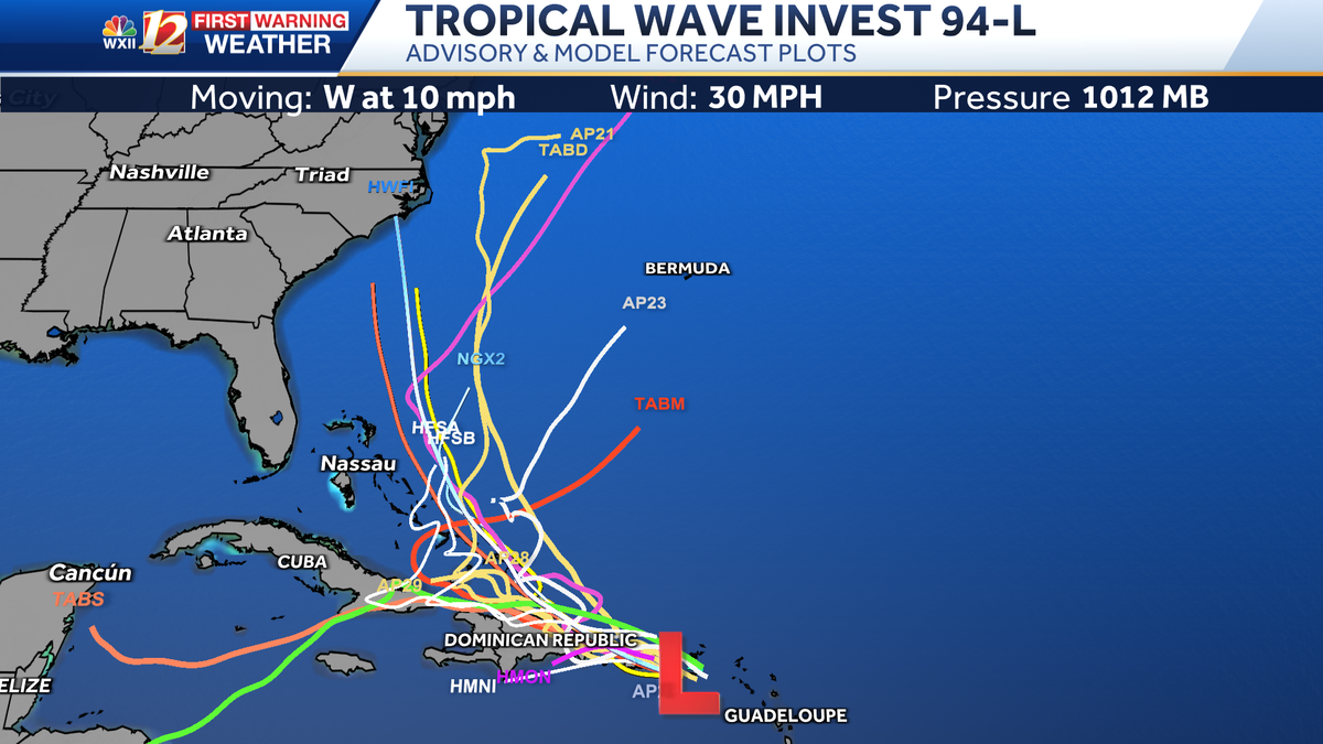
The tropical wave with the greatest potential impact near or along the North Carolina Coast early next week is known as Invest 94-L. This tropical wave has an 80% chance of development within the next week. First, the wave is expected to bring scattered heavy rain and storms to the Northern Leeward Islands, Puerto Rico and the U.S. Virgin Islands this week. Development of this tropical wave is expected to happen near the Bahamas as the storm drops its forward speed from its current pace of 15-20 mph.
Invest 94-L could become a depression later this week or weekend

While Invest 94-L has the best chance of impacting the Southeast U.S., the other tropical wave just to the east may become a depression sooner. The tropical wave east of the Lesser Antilles is known as Invest 93-L. It has a 90% chance of development within the next couple of days and is farther east in the Atlantic on a similar track to Gabrielle. The developing system may transition to Humberto or Imelda depending on whether the other tropical wave intensifies faster. Invest 93-L is currently on a path that could be a threat for Bermuda residents and potentially North Carolina.
Tropical wave Invest 93-L is becoming better organized

Spaghetti Model Plots for Potential Tropical Development

Tropical Slideshows
1 of 22
Tropical Areas of Interest and Current Storms
2 of 22
Tropical Advisory: Invest-94-L in the Atlantic Ocean near the Northern Leeward Islands
3 of 22
Tropical Advisory for Area of Interest: Tropical Wave Invest 93-L
4 of 22
Cone of Impact and Forecast Track: Gabrielle
PHOTO: WXII 12 Weather
5 of 22
Tropical Spaghetti Model Plots: Gabrielle
PHOTO: WXII 12 Weather
6 of 22
Latest Tropical Advisory: Gabrielle
PHOTO: WXII 12 News
7 of 22
Tropical System Categorie Based on Storm Wind Speeds
This chart shows the level of wind speeds in miles per hour that are needed to be categorized as a tropical system.
PHOTO: WXII 12 News
8 of 22
Estimated Wave Heights in the Atlantic: Gabrielle
9 of 22
Tropical Cyclone Heat Potential
10 of 22
Enhanced Satellite Imagery in the Atlantic: Gabrielle
11 of 22
Eastern Antilles and Windward Islands Wind Gust Speeds in Miles Per Hour
This image shows recent wind gusts in miles per hour over the Lesser Antilles and the Eastern Atlantic Ocean. Ocean buoy data is also included.
12 of 22
Latest Tropical Advisory: Gabrielle
PHOTO: WXII 12 News
13 of 22
Enhanced Satellite Imagery over the Gulf and Atlantic
14 of 22
North Carolina Coast Wind Gust Speed in Miles Per Hour
This image show rain, lightning strikes and wind gust speed in miles per hour in North Carolina.
15 of 22
Georgia and the Carolinas Wind Gust Speed & Radar
This image show rain, lightning strikes and wind gust speed in miles per hour from Georgia toward North Carolina.
16 of 22
Wind Gust Speed in Miles Per Hour: Inveest 90-L Soon to be T.S. Fernand
This image shows ocean buoy data and wind gust speed recorded by automated weather sites during Hurricane Erin’s approach to the North Carolina coast.
17 of 22
Florida to North Carolina Wind Gust Speeds in Miles Per Hour
This image shows wind gust speed in miles per hour from Florida to North Carolina. Satellite imagery shows cloud cover and any precipitation along the East Coast through the Outer Banks.
18 of 22
Central Caribbean Wind Gust Speeds in Miles Per Hour
This image shows recent wind gusts in miles per hour over the Central Caribbean and the Windward Islands.
19 of 22
Yucatan Wind Gust Speeds in Miles Per Hour
This image shows wind gust speed in miles per hour for the Yucatan Peninsula, the Gulf, and Texas. Satellite imagery shows cloud cover and any precipitation along the Gulf Coast through Cuba.
20 of 22
Southeast Wind Gust Speed in Miles Per Hour
This is an image of radar and wind gust speed displayed in miles per hour for the Southeast United States and the Gulf.
21 of 22
North Carolina Rainfall During Chantal
22 of 22
2024: Hurricane Helene’s Category 4 Landfall Over Florida
Hurricane Helene’s Category 4 Landfall in the Big Bend Area of Florida on September 26 at 11:10 p.m.
PHOTO: WXII 12 Weather
1 of 14
Tropical Advisory: Invest 93-L in the Atlantic Ocean
PHOTO: WXII 12 Weather
2 of 14
Tropical Infrared Satellite
This shows satellite imagery for the last few hours and includes any areas of interest and current named tropical systems that may be active in the Atlantic Ocean. For more information, check out our WXII 12 First Warning Interactive Radar and use the tropical layers.
3 of 14
Tropical Wave Height Forecast in the Atlantic
Tropical Wave Height Forecast for Gabrielle in the Atlantic
4 of 14
Tropical Storm Gabrielle Forecast Cone and Track
This model is using the European model to depict Gabrielle’s potential path over the central Atlantic along with the official track from the National Hurricane Center.
PHOTO: WXII 12 Weather
5 of 14
Tropical Storm Fernand Spaghetti Model Plots
This image shows various forecast models for resolving the potential path for Fernand over the Northern Atlantic along with the official track from the National Hurricane Center.
PHOTO: WXII 12 Weather
6 of 14
Tropical Frequency of Storms by Day in Hurricane Season
This graphic shows the topical frequency of storms by Day in Hurricane Season
7 of 14
North Carolina Coast: Rainfall Intensity and Wind Gust Speed in Miles Per Hour
8 of 14
Georgia and South Carolina: Rainfall Intensity and Wind Gust Speed in Miles Per Hour
9 of 14
Tropical Activity: Wind Gust Speed in the Mid-Atlantic
This image shows Ocean and bay buoy wind gust speed data in miles per hour.
10 of 14
Tropical Wind Gust Speed in Miles Per Hour: Florida and the Gulf
11 of 14
Tropical Wind Gust Speed in Miles Per Hour: Bahamas and Greater Antilles
PHOTO: WXII 12 Weather
12 of 14
Wind Gust Speed in Miles Per Hour: Puerto Rico and the Antilles
13 of 14
Sea Surface Water Temperature in the Atlantic
14 of 14
Tropical West Africa Infrared Satellite Imagery
Are you ready for tropical impacts in North Carolina?
The historically busiest tropical months still lie ahead. The 2025 Atlantic hurricane season continues through Nov. 30.
Piedmont Triad residents can stay alert, informed and prepared by following these tips:
WXII INTERACTIVE STUDIO: EXPLORE MORE
Lanie Pope explains Helene’s massive flooding, why it was potentially a 100-year flood event for the state in the interactive video featured below:
It’s the worst of the worst to ever hit North Carolina, as Dylan Hudler explains the names our state will never forget in the interactive video featured below:
It’s not just the coast that gets hit with devastating impacts from hurricanes, as Brian Slocum explains, why monster storms leave lasting impacts in the interactive video featured below:
Hurricane Hugo brought massive devastation to the Carolinas, as Dave Aiken explains with an in-depth look at the disastrous storm in the interactive video featured below.
Find out the best ways to prepare for hurricane season as Michelle Kennedy explains what you can do now instead of waiting to do later in the interactive video featured below:
More weather coverage: Weather Alerts | Closing and delays | Latest weather forecast | Post pictures to the uLocal North Carolina Facebook Group | Traffic information | Report closings and delays | SkyCams | Download the WXII12 News mobile app