
Humberto is forecast to strengthen over the open Atlantic as it follows a path similar to Gabrielle. The system is forecast to become a Category 3 hurricane status on a west-northwest track that may coincide with another tropical system that may become Imelda. The twin tropical systems may interact with one another and change storm intensities as well as tracks as they approach the Southeast U.S. coast. East Coast impacts are likely by next weekThere is a lot of uncertainty about whether these two tropical systems in the Atlantic will get close enough to the U.S. coast to bring major tropical impacts, but coastal impacts from big waves and rip currents are already developing. The storms are projected to move between the North Carolina coast and Bermuda. The steering currents aloft favor keeping the storms offshore from Bermuda and the U.S., but the system that becomes Imelda may ride close to the Gulf stream and influence Humberto’s journey too over the Atlantic. For more about the Fujiwhara effect that may occur when two tropical cyclones interact, read Meteorologist Michelle Kennedy’s story here.Tropical Storm Advisory: Humberto National Hurricane Center meteorologists are issuing advisories on Humberto, and the National Oceanic and Atmospheric Administration have Hurricane Hunters crews flying into the storm to gather more details.Tropical Track: HumbertoTropical Spaghetti Models: HumbertoImelda may form soon and move near Humberto in AtlanticThe second tropical area of concern will bring heavy rain and storms to Puerto Rico and the Dominican Republic in the Caribbean before it drifts into the Atlantic to strengthen into the next named system, Imelda.Tropical Advisory: Tropical Wave Invest 94-LTropical Track: Tropical Wave Invest 94-LTropical Spaghetti Models: Tropical Wave Invest 94-LGabrielle continues to bring threats to the Azores, and remnants from the storm may wrap back toward Portugal and slide south toward Northern African.Areas to Watch in the TropicsOver the next few weeks, the WXII 12 First Warning Weather Team will be focused on three main areas for tropical development:The Gulf: Very warm sea surface temperatures can help fledgling storms explode into monster hurricanes quickly under the right atmospheric conditions.Africa: In late summer, waves of low pressure often move from the Sahara Desert into the eastern Atlantic. They can develop into tropical systems over time. The sub-tropical high-pressure system over the Atlantic will often steer these systems through the tropical Atlantic towards Central America and the United States.Southeast U.S. Coast: Weaker, short-lived storms often form in late summer or fall along the old frontal boundaries. Areas of offshore low pressure can become tropical. These storms can become dangerous quickly because they are so close to the coast.Are you prepared for inland tropical impacts in North Carolina and Virginia?September and October are historically the busiest tropical months for the Carolinas. The 2025 Atlantic hurricane season continues through Nov. 30.Piedmont Triad residents can stay alert, informed and prepared:Know your evacuation routes and have an emergency plan.Monitor the forecasts on WXII 12 News or WXII12.com.Review insurance coverage and protect important documents, especially in light of past flooding events like Helene (2024) and Chantal (2025).Have an emergency preparedness kit: water, batteries, flashlights, and medications in case of power loss.WXII INTERACTIVE STUDIO: EXPLORE MORELanie Pope explains Helene’s massive flooding, why it was potentially a 100-year flood event for the state in the interactive video featured below:It’s the worst of the worst to ever hit North Carolina, as Dylan Hudler explains the names our state will never forget in the interactive video featured below:It’s not just the coast that gets hit with devastating impacts from hurricanes, as Brian Slocum explains, why monster storms leave lasting impacts in the interactive video featured below:Hurricane Hugo brought massive devastation to the Carolinas, as Dave Aiken explains with an in-depth look at the disastrous storm in the interactive video featured below.Find out the best ways to prepare for hurricane season as Michelle Kennedy explains what you can do now instead of waiting to do later in the interactive video featured below:More weather coverage: Weather Alerts | Closing and delays | Latest weather forecast | Post pictures to the uLocal North Carolina Facebook Group | Traffic information | Report closings and delays | SkyCams | Download the WXII12 News mobile app
WINSTON-SALEM, N.C. —
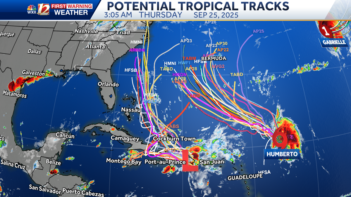
Humberto is forecast to strengthen over the open Atlantic as it follows a path similar to Gabrielle. The system is forecast to become a Category 3 hurricane status on a west-northwest track that may coincide with another tropical system that may become Imelda. The twin tropical systems may interact with one another and change storm intensities as well as tracks as they approach the Southeast U.S. coast.
East Coast impacts are likely by next week
There is a lot of uncertainty about whether these two tropical systems in the Atlantic will get close enough to the U.S. coast to bring major tropical impacts, but coastal impacts from big waves and rip currents are already developing. The storms are projected to move between the North Carolina coast and Bermuda. The steering currents aloft favor keeping the storms offshore from Bermuda and the U.S., but the system that becomes Imelda may ride close to the Gulf stream and influence Humberto’s journey too over the Atlantic. For more about the Fujiwhara effect that may occur when two tropical cyclones interact, read Meteorologist Michelle Kennedy’s story here.
Tropical Storm Advisory: Humberto

Hearst OwnedWXII 12 Weather
National Hurricane Center meteorologists are issuing advisories on Humberto, and the National Oceanic and Atmospheric Administration have Hurricane Hunters crews flying into the storm to gather more details.
This content is imported from Facebook.
You may be able to find the same content in another format, or you may be able to find more information, at their web site.
Tropical Track: Humberto

Hearst OwnedWXII 12 Weather
Tropical Spaghetti Models: Humberto

Imelda may form soon and move near Humberto in Atlantic
The second tropical area of concern will bring heavy rain and storms to Puerto Rico and the Dominican Republic in the Caribbean before it drifts into the Atlantic to strengthen into the next named system, Imelda.
Tropical Advisory: Tropical Wave Invest 94-L

Tropical Track: Tropical Wave Invest 94-L
Tropical Spaghetti Models: Tropical Wave Invest 94-L

Gabrielle continues to bring threats to the Azores, and remnants from the storm may wrap back toward Portugal and slide south toward Northern African.

Areas to Watch in the Tropics
Over the next few weeks, the WXII 12 First Warning Weather Team will be focused on three main areas for tropical development:
The Gulf: Very warm sea surface temperatures can help fledgling storms explode into monster hurricanes quickly under the right atmospheric conditions.Africa: In late summer, waves of low pressure often move from the Sahara Desert into the eastern Atlantic. They can develop into tropical systems over time. The sub-tropical high-pressure system over the Atlantic will often steer these systems through the tropical Atlantic towards Central America and the United States.Southeast U.S. Coast: Weaker, short-lived storms often form in late summer or fall along the old frontal boundaries. Areas of offshore low pressure can become tropical. These storms can become dangerous quickly because they are so close to the coast.
Are you prepared for inland tropical impacts in North Carolina and Virginia?
September and October are historically the busiest tropical months for the Carolinas. The 2025 Atlantic hurricane season continues through Nov. 30.
Piedmont Triad residents can stay alert, informed and prepared:
WXII INTERACTIVE STUDIO: EXPLORE MORE
Lanie Pope explains Helene’s massive flooding, why it was potentially a 100-year flood event for the state in the interactive video featured below:
It’s the worst of the worst to ever hit North Carolina, as Dylan Hudler explains the names our state will never forget in the interactive video featured below:
It’s not just the coast that gets hit with devastating impacts from hurricanes, as Brian Slocum explains, why monster storms leave lasting impacts in the interactive video featured below:
Hurricane Hugo brought massive devastation to the Carolinas, as Dave Aiken explains with an in-depth look at the disastrous storm in the interactive video featured below.
Find out the best ways to prepare for hurricane season as Michelle Kennedy explains what you can do now instead of waiting to do later in the interactive video featured below:
More weather coverage: Weather Alerts | Closing and delays | Latest weather forecast | Post pictures to the uLocal North Carolina Facebook Group | Traffic information | Report closings and delays | SkyCams | Download the WXII12 News mobile app