
TROPICS: We have two named systems and an area of interest this morning
*GABRIELLE: Hurricane Gabrielle, with winds of 85 mph, is about 650 miles west of the Azores. It is moving quickly to the east at 32 mph, and will become post tropical tomorrow.
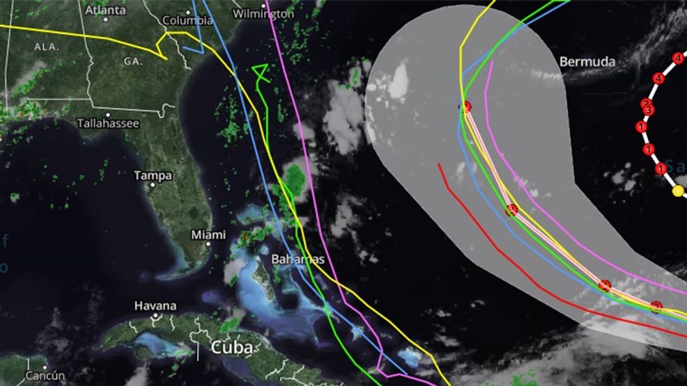
*HUMBERTO: Tropical Storm Humberto, with winds of 45 mph, is about 480 miles east/northeast of the northern Leeward Islands. It is moving to the northwest at 10 mph. The NHC forecast brings the system to Hurricane strength by Sunday; it will pass between Bermuda and the U.S. east coast Tuesday and Wednesday of next week before it heads out into the open North Atlantic. No threat to land.
*INVEST 94L: A tropical wave centered near the Dominican Republic continues to produces widespread disorganized showers and thunderstorms. The wave is expected to move west-northwestward around 10 to 15 mph, spreading heavy rainfall and gusty winds across Puerto Rico and the Dominican Republic through today. The system is then expected to slow down and turn northwestward when it reaches the southwestern Atlantic. A tropical depression is likely to form when the disturbance is in the vicinity of the Bahamas late this week.
NHC gives it an 80 percent chance of development; the name will be “Imelda”. Models have shifted to the left, and there is potential for the system to make landfall somewhere on the coast of the Carolinas early next week. But, a number of model ensemble members show a hard turn to the east away from the U.S. before reaching the coast. Once the system develops and data from hurricane hunter aircraft is gathered, forecast confidence will be higher.
No tropical storms or hurricanes are expected across the Gulf for at least the next 7-10 days.