

A low-category hurricane, soon to be named Imelda, may reach coastal Georgia and the Carolinas early next week, the National Weather Service (NWS) predicts. Or at least, a tropical storm near or at hurricane-intensity.
“Later in the day on Monday we’ll really see conditions start to deteriorate,” said NWS meteorologist Carl Barnes at a 6 p.m. briefing on Sept. 26.
Invest 94L has transformed into even more of a mouthful: “Potential Tropical Cyclone 9.” That’s because it’s not yet a well-formed storm, though the NWS says it will organize into a cyclone over the weekend as it showers stormy weather on the Bahamas.
This weekend’s rain in Savannah is unrelated to the impending Imelda. But when the system reaches hurricane strength early next week, coastlines from Georgia to the southern mid-Atlantic states can expect a surge of flooding, high surf, rip currents, beach erosion, heavy rainfall and high winds. Tornadoes are also possible, said the NWS forecast.
“We are expecting the greatest rainfall amounts to be along and to the right or to the east of the center track of the storm” along coastal South Carolina and potentially southeast Georgia, said Barnes. The NWS expects the most severe conditions to occur late Monday night through Tuesday night.

Potential Tropical Cyclone 9’s Hazard and Impact Summary as of 6 p.m. on Sept. 26
While the National Hurricane Center’s map seems pretty clear about where Potential Tropical Cyclone 9 is headed, “this doesn’t mean that we have any less uncertainty than we did before,” said Barnes.
It ultimately depends which storm is faster: Humberto, or soon-to-be Imelda (aka Potential Tropical Storm 9).
Scenario 1: If Potential Tropical Storm 9 moves ahead of Humberto, the storm would be able to intensify on its own, most likely making landfall along the South Carolina coast. From there, it could stall out or push further inland. This scenario has “the highest potential for more robust set of impacts, with significant wind surge, rainfall and tornado impacts,” said Barnes.
Scenario 2: The storm approaches the coast, slows down significantly, stalling near the South Carolina coast. While there would be less immediate threats inland, there would be still elevated threats along the coast including prolonged winds and heavy rainfall.
Scenario 3: If Humberto moves north faster than Potential Tropical Cyclone 9 is able to organize and begin to move north, the potential tropical cyclone could get pulled farther from the coast. Impacts to the coast would be minimal.
“Unfortunately, at this point, we still don’t have a great feel for exactly what’s going to happen, but scenarios one and two are our greatest concern right now,”‘ said Barnes.
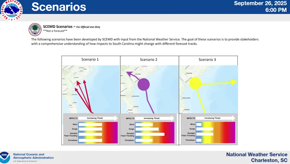
Scenarios for Potential Tropical Storm 9 (soon to be Imelda) as of 6 p.m. on Sept. 26
Residents “should ensure they have their hurricane plan in place,” the NWS said. The National Weather Service’s guidance on how to prepare for hurricane season can be found at weather.gov/safety/hurricane.
More: Humberto complicates 94L’s path
Sandbags for Savannahians
The City of Savannah announced that it has entered Operating Condition 4, the monitoring phase in a press release sent Friday evening. As part of that status, emergency response staff with Savannah is on standby for the weekend.
Savannah residents and businesses can pick up sand and sandbags Saturday, Sept. 27 and Sunday, Sept. 28, from 11 a.m. to 4 p.m., while supplies last.
Sandbags will be limited to five per household, and residents must bring their own shovels. Supplies will be available until they run out at the EnMarket Arena Parking Lot (630 Stiles Ave.) and Savannah Fire Station #7 (6902 Sallie Mood Drive).
Port Wentworth Emergency Management said they will be monitoring the storm and providing updates on any potential road closures due to flooding on its Facebook.
The City of Pooler will have sand and sandbags on hand, but the decision whether to make them available will most likely come on Sunday, Mayor Karen Williams said on Facebook. There are already emergency staff on standby for the entire weekend. Public Works crews have also been redirected to concentrate on inspecting culverts and cleaning out drains to help with any potential flooding.
Updates will be provided as they become available.
Jillian Magtoto covers climate change and the environment in coastal Georgia. You can reach her at jmagtoto@gannett.com. Destini Ambus is the general assignment reporter for the Savannah Morning News, covering the municipalities, and community and cultural programs. You can reach her at DAmbus@gannett.com
This reporting content is supported by a partnership with Green South Foundation, Prentice Foundation and Journalism Funding Partners.
This article originally appeared on Savannah Morning News: Savannah braces for flooding, rain, and storm impacts early next week