
Tropical Depression Nine is moving very slowly at about 3 mph to the northwest over The Bahamas. As Nine continues slowly drifting over the region, it will bring torrential tropical rainfall to The Bahamas, Cuba and may bring tropical storm-force winds to Florida’s East Coast. Georgia, South Carolina and North Carolina residents will want to monitor this storm as heavy coastal rain is likely and track changes with higher inland impact may still develop.Tropical Storm Warnings in FloridaThe National Hurricane Center meteorologists are issuing tropical advisories on Nine and Hurricane Humberto. You can also find tropical advisories in Spanish here for T.D. Nine. Advisories for the massive Hurricane Humberto can be found here; Hurricane Humberto advisories in Spanish can be found here.From Florida to South Carolina, rainfall up to six inches is possible now through Tuesday. Although track uncertainty remains, heavy rain ahead of future Imelda may develop Monday and continue through early Thursday with 10 to 12 inch totals possible along the southern coast of North Carolina. Periods of scattered showers and storms may bring up to two inch totals for the Eastern Piedmont Triad.Tropical Depression Nine rainbands seen from Puerto Rico Nine is slow to progress, track offshore of Carolinas nowTropical Depression Nine is projected to become Tropical Storm Imelda and eventually a Category 1 hurricane; North Carolina inland impacts are lower on the current track for now, but high impacts to the coastal Carolinas are expected as the storm may linger over the warm Gulf Stream current. Nine is much slower in forward speed and growth than original forecast projections therefore, National Hurricane Center meteorologists believe a faster turn to the east may occur. This is a better scenario than earlier forecast tracks for the High Country of North Carolina where residents were concerned for flooding again from a tropical system so close to the date of Helene’s destruction last year, Sept. 26.Nine may become Tropical Storm Imelda as it moves parallel to the Florida Coastline.By Monday evening Imelda may become a Category 1 HurricaneBy Tuesday evening Hurricane Imelda begins moving east-northeast toward Bermuda.On Wednesday evening it may remain a Category 1 hurricane offshore southeast of Wilmington.On Thursday evening the storm may roll farther away from the Outer Banks and continue east toward Bermuda as it weakens.The latest official track has the storm remaining just offshore of South Carolina and Georgia while turning east instead of north toward North Carolina. There is still a risk heavy rainfall that may bring life-threatening flooding to North Carolina beaches from Monday through Wednesday.Complex weather patternThere is a great deal of complexity in the forecast given the juxtaposition of two tropical systems in close proximity; this lends to lower confidence in tropical tracks beyond 48 hours. Tropical Advisory: Tropical Depression Nine and Hurricane HumbertoTropical Tracks: Humberto and Tropical Depression NineTropical Spaghetti Model Plots: Humberto and Tropical Depression NineSlideshow: Check out looping satellites and forecast models National Hurricane Center meteorologists are issuing advisories on Tropical Depression Nine and Hurricane Humberto, and the National Oceanic and Atmospheric Administration have Hurricane Hunters crews flying into the storms to gather more details.The Fujiwhara effect may develop and help steer future Imelda farther away from North CarolinaTropical Depression Nine and Hurricane Humberto are projected to move between the North Carolina coast and Bermuda. Imelda may ride over the Gulf Stream and influence Humberto’s journey too over the Atlantic. The twin tropical systems may interact with one another and change storm intensities as well as tracks when they approach the Southeast U.S. coast early this coming week. For more about the Fujiwhara effect that occurs when two tropical cyclones are close enough to one another, read Meteorologist Michelle Kennedy’s story here.Forecast ChallengesWe expect a lot of updates to the forecast once Tropical Depression Nine becomes Imelda. This is expected to happen between now and Sunday evening. There are several forecast challenges as we monitor the tropics through the weekend. Challenges include: What happens with the steering currents aloft How much wind shear may impact Nine? What will Humberto’s intensity and forward movement be as Imelda forms from Tropical Depression Nine? Could a surface boundary and a ridge of high pressure keep Imelda near North Carolina’s coast longer and produce more rainfall?Humbertos swells may reach the Carolinas on MondayThere is a lot of uncertainty about whether Nine or future Hurricane Imelda will be close enough to the North Carolina coast to bring major impacts since the storm track is farther south and east than earlier Saturday. However, coastal impacts from big waves and rip currents are already developing as swells will reach shores in the Carolinas by Monday. Click here for more about tropical impacts expected in North Carolina, maps, models and beach forecasts..Hurricane Humberto becomes second Category 5 hurricane of the 2025 seasonHumberto became a powerful Category 5 hurricane over the open Atlantic on Saturday afternoon with hurricane-force winds of 160 mph extending out 25 miles from the center of the storm and tropical storm-force winds extend 125 miles from the eye. The hurricane is on a west-northwest track moving at 13 mph while Tropical Depression Nine is drifting north at 2 mph. Nine is forecast to become Tropical Storm Imelda sometime on Sunday. Areas to Watch in the TropicsOver the next few weeks, the WXII 12 First Warning Weather Team will be focused on three main areas for tropical development:The Gulf: Very warm sea surface temperatures can help fledgling storms explode into monster hurricanes quickly under the right atmospheric conditions.Africa: In late summer, waves of low pressure often move from the Sahara Desert into the eastern Atlantic. They can develop into tropical systems over time. The sub-tropical high-pressure system over the Atlantic will often steer these systems through the tropical Atlantic towards Central America and the United States.Southeast U.S. Coast: Weaker, short-lived storms often form in late summer or fall along the old frontal boundaries. Areas of offshore low pressure can become tropical. These storms can become dangerous quickly because they are so close to the coast.Are you prepared for inland tropical impacts in North Carolina and Virginia?September and October are historically the busiest tropical months for the Carolinas. The 2025 Atlantic hurricane season continues through Nov. 30.Piedmont Triad residents can stay alert, informed and prepared:Know your evacuation routes and have an emergency plan.Monitor the forecasts on WXII 12 News or WXII12.com.Review insurance coverage and protect important documents, especially in light of past flooding events like Helene (2024) and Chantal (2025).Have an emergency preparedness kit: water, batteries, flashlights, and medications in case of power loss.WXII INTERACTIVE STUDIO: EXPLORE MORELanie Pope explains Helene’s massive flooding, why it was potentially a 100-year flood event for the state in the interactive video featured below:It’s the worst of the worst to ever hit North Carolina, as Dylan Hudler explains the names our state will never forget in the interactive video featured below:It’s not just the coast that gets hit with devastating impacts from hurricanes, as Brian Slocum explains, why monster storms leave lasting impacts in the interactive video featured below:Hurricane Hugo brought massive devastation to the Carolinas, as Dave Aiken explains with an in-depth look at the disastrous storm in the interactive video featured below.Find out the best ways to prepare for hurricane season as Michelle Kennedy explains what you can do now instead of waiting to do later in the interactive video featured below:More weather coverage: Weather Alerts | Closing and delays | Latest weather forecast | Post pictures to the uLocal North Carolina Facebook Group | Traffic information | Report closings and delays | SkyCams | Download the WXII12 News mobile app
WINSTON-SALEM, N.C. —
Tropical Depression Nine is moving very slowly at about 3 mph to the northwest over The Bahamas. As Nine continues slowly drifting over the region, it will bring torrential tropical rainfall to The Bahamas, Cuba and may bring tropical storm-force winds to Florida’s East Coast. Georgia, South Carolina and North Carolina residents will want to monitor this storm as heavy coastal rain is likely and track changes with higher inland impact may still develop.
Tropical Storm Warnings in Florida
The National Hurricane Center meteorologists are issuing tropical advisories on Nine and Hurricane Humberto. You can also find tropical advisories in Spanish here for T.D. Nine. Advisories for the massive Hurricane Humberto can be found here; Hurricane Humberto advisories in Spanish can be found here.
From Florida to South Carolina, rainfall up to six inches is possible now through Tuesday. Although track uncertainty remains, heavy rain ahead of future Imelda may develop Monday and continue through early Thursday with 10 to 12 inch totals possible along the southern coast of North Carolina. Periods of scattered showers and storms may bring up to two inch totals for the Eastern Piedmont Triad.
Tropical Depression Nine rainbands seen from Puerto Rico
This content is imported from Facebook.
You may be able to find the same content in another format, or you may be able to find more information, at their web site.
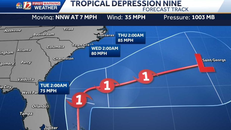
Nine is slow to progress, track offshore of Carolinas now
Tropical Depression Nine is projected to become Tropical Storm Imelda and eventually a Category 1 hurricane; North Carolina inland impacts are lower on the current track for now, but high impacts to the coastal Carolinas are expected as the storm may linger over the warm Gulf Stream current. Nine is much slower in forward speed and growth than original forecast projections therefore, National Hurricane Center meteorologists believe a faster turn to the east may occur. This is a better scenario than earlier forecast tracks for the High Country of North Carolina where residents were concerned for flooding again from a tropical system so close to the date of Helene’s destruction last year, Sept. 26.

Nine may become Tropical Storm Imelda as it moves parallel to the Florida Coastline.By Monday evening Imelda may become a Category 1 HurricaneBy Tuesday evening Hurricane Imelda begins moving east-northeast toward Bermuda.On Wednesday evening it may remain a Category 1 hurricane offshore southeast of Wilmington.On Thursday evening the storm may roll farther away from the Outer Banks and continue east toward Bermuda as it weakens.
The latest official track has the storm remaining just offshore of South Carolina and Georgia while turning east instead of north toward North Carolina. There is still a risk heavy rainfall that may bring life-threatening flooding to North Carolina beaches from Monday through Wednesday.
Complex weather pattern
There is a great deal of complexity in the forecast given the juxtaposition of two tropical systems in close proximity; this lends to lower confidence in tropical tracks beyond 48 hours.
Tropical Advisory: Tropical Depression Nine and Hurricane Humberto

Tropical Tracks: Humberto and Tropical Depression Nine

Tropical Spaghetti Model Plots: Humberto and Tropical Depression Nine

This content is imported from Facebook.
You may be able to find the same content in another format, or you may be able to find more information, at their web site.
Slideshow: Check out looping satellites and forecast models
1 of 17
Tropical Advisory: Tropical Depression Nine
2 of 17
Tropical Advisory: Invest 93-L in the Atlantic Ocean
PHOTO: WXII 12 Weather
3 of 17
Tropical Forecast Track and Advisory: Humberto and T.D, Nine
4 of 17
Georgia and South Carolina: Rainfall Intensity and Wind Gust Speed in Miles Per Hour
5 of 17
Potential Tropical Rainfall: GFS Model for rain in North Carolina
6 of 17
Potential Tropical Rainfall: Euro Model for rain in North Carolina
7 of 17
Tropical Storm-Force Wind Probability: % Chance of Wind Above 39 mph
8 of 17
Wind Gust Speed Forecast in Miles Per Hour: North Carolina and South Carolina
9 of 17
Tropical Potential Rain and Storms: GFS Model
10 of 17
Tropical Potential Rain and Storms: EURO Model
11 of 17
Tropical Infrared Satellite
This shows satellite imagery for the last few hours and includes any areas of interest and current named tropical systems that may be active in the Atlantic Ocean. For more information, check out our WXII 12 First Warning Interactive Radar and use the tropical layers.
12 of 17
Tropical Ocean: Wave Height in the Atlantic and Gulf
PHOTO: WXII 12 Weather
13 of 17
Tropical Activity: Wind Gust Speed in the Mid-Atlantic
This image shows Ocean and bay buoy wind gust speed data in miles per hour.
14 of 17
Tropical Wind Gust Speed Forecast: Future Imelda and Hurricane Humberto
15 of 17
Wind Gust Speed in Miles Per Hour: Puerto Rico and the Antilles
16 of 17
Sea Surface Water Temperature in the Atlantic
17 of 17
Tropical West Africa Infrared Satellite Imagery
National Hurricane Center meteorologists are issuing advisories on Tropical Depression Nine and Hurricane Humberto, and the National Oceanic and Atmospheric Administration have Hurricane Hunters crews flying into the storms to gather more details.
The Fujiwhara effect may develop and help steer future Imelda farther away from North Carolina
Tropical Depression Nine and Hurricane Humberto are projected to move between the North Carolina coast and Bermuda. Imelda may ride over the Gulf Stream and influence Humberto’s journey too over the Atlantic. The twin tropical systems may interact with one another and change storm intensities as well as tracks when they approach the Southeast U.S. coast early this coming week. For more about the Fujiwhara effect that occurs when two tropical cyclones are close enough to one another, read Meteorologist Michelle Kennedy’s story here.
This content is imported from YouTube.
You may be able to find the same content in another format, or you may be able to find more information, at their web site.
Forecast Challenges
We expect a lot of updates to the forecast once Tropical Depression Nine becomes Imelda. This is expected to happen between now and Sunday evening. There are several forecast challenges as we monitor the tropics through the weekend. Challenges include:
What happens with the steering currents aloft How much wind shear may impact Nine? What will Humberto’s intensity and forward movement be as Imelda forms from Tropical Depression Nine? Could a surface boundary and a ridge of high pressure keep Imelda near North Carolina’s coast longer and produce more rainfall?
Humbertos swells may reach the Carolinas on Monday
There is a lot of uncertainty about whether Nine or future Hurricane Imelda will be close enough to the North Carolina coast to bring major impacts since the storm track is farther south and east than earlier Saturday. However, coastal impacts from big waves and rip currents are already developing as swells will reach shores in the Carolinas by Monday. Click here for more about tropical impacts expected in North Carolina, maps, models and beach forecasts..
Hurricane Humberto becomes second Category 5 hurricane of the 2025 season
Humberto became a powerful Category 5 hurricane over the open Atlantic on Saturday afternoon with hurricane-force winds of 160 mph extending out 25 miles from the center of the storm and tropical storm-force winds extend 125 miles from the eye. The hurricane is on a west-northwest track moving at 13 mph while Tropical Depression Nine is drifting north at 2 mph. Nine is forecast to become Tropical Storm Imelda sometime on Sunday.
This content is imported from Twitter.
You may be able to find the same content in another format, or you may be able to find more information, at their web site.
Humberto was a Category 1 hurricane with 90-mile-an-hour winds in the Atlantic Ocean when Jonny Kim photographed the storm on Sept. 26. https://t.co/Z51EPwsFeM
— International Space Station (@Space_Station) September 27, 2025
Areas to Watch in the Tropics
Over the next few weeks, the WXII 12 First Warning Weather Team will be focused on three main areas for tropical development:
The Gulf: Very warm sea surface temperatures can help fledgling storms explode into monster hurricanes quickly under the right atmospheric conditions.Africa: In late summer, waves of low pressure often move from the Sahara Desert into the eastern Atlantic. They can develop into tropical systems over time. The sub-tropical high-pressure system over the Atlantic will often steer these systems through the tropical Atlantic towards Central America and the United States.Southeast U.S. Coast: Weaker, short-lived storms often form in late summer or fall along the old frontal boundaries. Areas of offshore low pressure can become tropical. These storms can become dangerous quickly because they are so close to the coast.
Are you prepared for inland tropical impacts in North Carolina and Virginia?
September and October are historically the busiest tropical months for the Carolinas. The 2025 Atlantic hurricane season continues through Nov. 30.
Piedmont Triad residents can stay alert, informed and prepared:
WXII INTERACTIVE STUDIO: EXPLORE MORE
Lanie Pope explains Helene’s massive flooding, why it was potentially a 100-year flood event for the state in the interactive video featured below:
It’s the worst of the worst to ever hit North Carolina, as Dylan Hudler explains the names our state will never forget in the interactive video featured below:
It’s not just the coast that gets hit with devastating impacts from hurricanes, as Brian Slocum explains, why monster storms leave lasting impacts in the interactive video featured below:
Hurricane Hugo brought massive devastation to the Carolinas, as Dave Aiken explains with an in-depth look at the disastrous storm in the interactive video featured below.
Find out the best ways to prepare for hurricane season as Michelle Kennedy explains what you can do now instead of waiting to do later in the interactive video featured below:
More weather coverage: Weather Alerts | Closing and delays | Latest weather forecast | Post pictures to the uLocal North Carolina Facebook Group | Traffic information | Report closings and delays | SkyCams | Download the WXII12 News mobile app