
Tropical Storm Imelda stronger now, brings big waves to the beaches and rain into the Triad; here’s what to know
MINUTE TO TO JOIN IN, BUT WE’RE GOING TO KIND OF EXTENSIVELY GO THROUGH THE LATEST THAT CAME IN WITH THE 11:00 ADVISORY. THERE HAVE BEEN A COUPLE OF CHANGES, ESPECIALLY WITH REGARD TO THE INTENSITY OF BOTH HURRICANE HUMBERTO AND TROPICAL STORM IMELDA. SO I’M GOING TO GIVE FOLKS A MINUTE TO KIND OF JOIN IN AND SO WE CAN DIGEST ALL OF THIS WONDERFUL NEW INFORMATION. A LOT GOING ON. TOO MUCH GOING ON. IF YOU IF YOU ASK ME. BUT IT’S ALWAYS INTERESTING WHEN YOU GOT TWO TROPICAL SYSTEMS AS LARGE AS THESE TWO SYSTEMS ARE GETTING CLOSE TO ONE ANOTHER. THINGS CAN HAPPEN. SO. WELL, WE’LL START IN ABOUT 30S. WE’RE GOING TO TALK FOR A WHILE. GOT MY WATER. SOMEBODY TOLD ME MY OJALA WAS BORING. BECAUSE ITS COLORS ARE ALL THE SAME. I TOOK OFFENSE TO THAT. ALL RIGHT, LET’S GO AHEAD AND GET STARTED. THE 11:00 ADVISORY CAME IN THIS MORNING. BY THE WAY, I’M METEOROLOGIST BRIAN SLOCUM. THANKS FOR JOINING US TODAY. WE GOT ONE MAJOR HURRICANE OUT THERE AND ONE TROPICAL STORM. IT’S REALLY STARTING TO GET BETTER ORGANIZED. SO ON THE RIGHT WE HAVE HURRICANE HUMBERTO. IT’S A CATEGORY FOUR. THE WINDS WERE STARTING TO COME DOWN A LITTLE BIT FROM THAT STORM SYSTEM. BUT THEN SOMETIME THIS MORNING HURRICANE HUNTER AIRCRAFT STARTED TO FLY THROUGH THIS AND SAID, WHOA, WAIT A MINUTE. THESE WINDS ARE ACTUALLY STRONGER THAN WE THOUGHT. SO IT WENT FROM 130 WHERE IT WAS AT THE TIME, AND THEN BUMPED IT UP TO 145. AND IT STILL KIND OF IN THAT RANGE. THE EYE DISAPPEARED A WHILE BACK. IT WENT THROUGH WHAT’S CALLED AN EYEWALL REGENERATION CYCLE. THE SIMPLIFIED VERSION OF THAT IS THE WINDS AROUND THE CENTER ARE SPINNING SO FAST THAT IT CAN’T HOLD ITS STRUCTURE TOGETHER VERY LONG. AND IT’S STILL SPINNING, BUT THE EYEWALL TENDS TO GET RAGGED. IT TENDS TO FALL APART. SOMETIMES CLOUDS OBSCURE IT A LITTLE BIT LIKE IT HAS BEEN, AND THEN IT REFORMS. AT SOME PONT IT COULD BE LARGER, IT COULD BE SMALLER, BUT AND SOMETIMES IT EVEN REFORMS IN A DIFFERENT PLACE. BUT IT’S KIND OF GOING THROUGH THAT NOW, HOPING THAT I WILL POKE OUT AGAIN SOON. BUT IT IS A POWERFUL CAT FOUR ON THE LEFT YOU HAVE TROPICAL STORM IMELDA. THIS STORM TOOK FOREVER TO DEVELOP, INTERACTED WITH LAND. IT HAD SOME DRY AIR OVER FLORIDA THAT WAS DEALING WITH IT, BUT IT’S BEEN OVER WARM WATERS AND THEN KIND OF RACING THROUGH THE BAHAMAS. AND JUST THIS MORNING WE’VE BEEN NOTICING SOME BETTER ORGANIZATION WITH THIS STORM SYSTEM. IT’S STARTING TO GET MORE OF A CLASSIC TROPICAL STORM SHAPE. IT IS EXPANDING IN SIZE A BIT MORE, AND IT IS STILL MOVING TO THE NORTH. SO YOU CAN SEE ON THE SATELLITE AND RADAR IMAGE TOGETHER THAT WE DO HAVE BANDS OF RAIN THAT ARE ALREADY STARTING TO TO MOVE IN. COASTAL BANDS HAVE BEEN MORE OBVIOUSLY. WE’VE LOOKED OUT THE WINDOW AND YOU LIVE IN THE PIEDMONT TRIAD. IT’S IT’S BEEN RAINING PRETTY LIGHTLY FOR THE LAST COUPLE OF HOURS. OUTER BANKS TO THE NORTH. NOT LOOKING TOO BAD AT ALL FOR AT LEAST INITIAL IMPACTS. WE’VE SEEN OCCASIONAL GUSTS AROUND 20 OR 25MPH. PINEY ISLAND HAS BEEN SHOWING MOST OF THAT, NOT SEEING TOO MUCH ELSE OTHER THAN A FEW PATCHY SHOWERS. BUT MOST OF THE RAIN HAS MOVED INLAND. THE RAINFALL FORECASTS HAVE CHANGED A BIT. WE’RE GOING TO GO OVER THAT TOO AS WE GO THROUGH TIME, BUT AT LEAST THE LATEST WE’LL START WITH HUMBERTO STORM. IT’S BEEN MORE LONG LIVED. THIS IS THIS IS THE BOWLING BALL IN THE ATLANTIC RIGHT NOW. A PRETTY LARGE STORM. IT’S NOT AS SYMMETRICAL AS IT WAS. PEAK WINDS WERE AT 160 ON SATURDAY. THAT’S CAT FIVE STRENGTH. AND THEN IT SOME THE INTENSITY DROPPED A LITTLE BIT. IT’S BEEN A CAT FOUR PRETTY MUCH EVER SINCE THAT POINT. MOVEMENT’S BEEN STEADY NORTHWEST IN THE TEENS RIGHT NOW. IT’S AT 13MPH. WE WATCH FOR PRESSURE FLUCTUATIONS FROM THE 8:00 ADVISORY TO THE 11 A.M. ADVISORY. THE PRESSURE DROPPED, AND THAT MIGHT BE AN INDICATION OF STRENGTHENING WHEN THE WINDS ARE THIS FAST, IT’S GOING TO FLUCTUATE IN STRENGTH A BIT. THE GENERAL TREND IS FOR THIS STORM TO START WEAKENING AS WE GO THROUGH TIME. AND YOU CAN SEE THAT THE TRACK REALLY HASN’T CHANGED VERY MUCH OF THIS STORM. BUT NOTICE WE PUT ALSO IMELDA ON THIS MAP TO TO KIND OF GIVE YOU AN IDEA HOW CLOSE THESE STORMS ARE GOING TO GET TOGETHER BEFORE FIRST UMBERTO STARTS TO TO MOVE OUT AND THEN THE REST FOLLOW. SO EVENTUALLY WE’LL PASS NEAR BERMUDA. BERMUDA ESSENTIALLY IS CENTERED RIGHT HERE, KIND OF GOING AROUND THE ISLAND NATION AT THAT POINT. SO THE EFFECTS OF THIS, THE STORM IS BROAD ENOUGH WHERE THEY’LL LIKELY SEE TROPICAL STORM CONDITIONS DEVELOPING BY LATE TOMORROW. THE BIGGEST ISSUE WITH ALL OF THESE STORMS, WITH REGARD TO BERMUDA AND THE UNITED STATES, IS GOING TO BE THE ROUGH SURF THAT THAT CREATES THE RIP CURRENTS, THE BIG SWELLS. I MEAN, THERE’S TWO BIG STORMS OUT THERE IN CLOSE PROXIMITY TO THE US. THIS IS GOING TO MESS WITH THE BEACHES. THE OVERWASH COULD SEE SOME BEACH EROSION FROM THIS. AND EVEN THOUGH THEY’RE RELATIVELY QUICK MOVERS AND STAYING OFFSHORE, THE FACT THAT THERE’S TWO OF THEM YOU’VE GOT IT’S LIKE A BLENDER OUT THERE AND IT’S GOING TO REALLY KIND OF MESS WITH SURF FOR AT LEAST A FEW DAYS THIS WEEK. SO THAT’S AS OF THE 11:00 ADVISORY WITH HUMBERTO. WATCH HOW THESE TWO STORMS INTERACT. AND I WANT TO SHOW YOU THIS BEFORE WE SHOW YOU THE TRACK OF TROPICAL STORM IMELDA. NOTICE AT ONE POINT THAT THESE STORMS ALMOST CONNECT A LITTLE BIT. THEY GET CLOSE ENOUGH WITHIN ABOUT 800 MILES OR SO, WHERE ONE BAND KIND OF WRAPS AROUND INTO THE OTHER. AND WHETHER OR NOT THAT HAPPENS OR NOT, IT JUST SHOWS YOU THAT THESE TWO THINGS ARE KIND OF ARE STEERING FORCES ON THEIR OWN. IT’S AN AREA OF LOW PRESSURE. IT PULLS THINGS IN. SO THESE ARE LIKE TWO GIANT MAGNETS IN A WAY. AND THEY’RE LOOKING FOR AREAS OF LOW PRESSURE TO FLOW IN. SO THIS BEING THE DOMINANT STORM IT’S GOING TO TUG ON THIS ONE A LITTLE BIT WHEN ONCE THEY GET CLOSE ENOUGH. AND AS THIS STARTS TO MOVE AROUND A RIDGE OF HIGH PRESSURE IN THE ATLANTIC, IT’S GOING TO PULL THIS ONE BEHIND IT, WHICH IS GOING TO AFFECT THE INTENSITY OF THE STORM A LITTLE BIT. BUT IT’S ALSO THE MAIN STEERING FORCE THAT’S GOING TO PULL THIS THING AWAY FROM THE UNITED STATES. IF YOU HAVEN’T SEEN ANYTHING ABOUT THE TROPICS SINCE, MAYBE FRIDAY, IF YOU’RE WATCHING AT WORK AND JUST KIND OF TOOK THE WEEKEND OFF AND JUST CHILLED OUT, HEY, I’M WITH YOU. THE FORECAST HAS CHANGED CONSIDERABLY SINCE FRIDAY BECAUSE BEGINNING FRIDAY EVENING, THE STRM THAT INITIALLY LOOKED LIKE IT WAS GOING TO CURVE BACK INTO SOUTH CAROLINA AND PERHAPS MOVE INTO WESTERN NORTH CAROLINA. IT’S NOT WHAT YOU WANT TO HEAR ON THE ANNIVERSARY OF HELENE, THE FORECAST HAS CHANGED CONSIDERABLY AS WHAT WAS TROPICAL DEPRESSION NINE AND NOW IMELDA WAS MOVING SLOW ENOUGH NEAR THE CARIBBEAN ISLANDS THAT IT WAS NOT GETTING PICKED UP BY THE STEERING FORCES THAT WAS GOING TO PULL IT INTO THE UNITED STATES IN THE FIRST PLACE. SO THERE’S A LOT MOVING AROUND. THERE’S A LOT OF MOVING PARTS. TIMING IS ESSENTIAL AS FAR AS WHERE THE STORM GETS STEERED, BECAUSE ALL OF THESE STEERING FORCES ARE MOVING THEMSELVES. SO IF IT’S A LITTLE SLOWER THAN EXPECTED, IT MIGHT NOT GET PICKED UP BY ONE STEERING FORCE AND THEN GETS PICKED UP BY ANOTHER. AND THAT’S KIND OF WHAT’S HAPPENING HERE. BUT THERE’S A STATIONARY FRONT NEAR THE COAST, TOO, AND THAT’S GOING TO ENHANCE RAINFALL A LITTLE BIT. I JUST WANT TO MENTION THAT NOW. BUT LOOK HOW QUICKLY ONE STORM FOLLOWS THE OTHER OUT. AND REALLY SINCE FRIDAY NIGHT WE HAVE BEEN WATCHING THIS TREND IN THE MODELS MOVING NORTH FOR A WHILE AND THEN KICKED OUT EAST NORTH FOR A WHILE, FOR A COUPLE OF DAYS, AND THEN GET KICKED OUT TO THE EAST. IT SEEMS LIKE MAYBE TWICE A DAY, MAYBE EVEN FOUR TIMES A DAY WHEN THESE MODELS UPDATE, THE TURN COMES A LITTLE MORE QUICKLY, AND THERE’S BEEN A COUPLE OF OTHER ISSUES WITH THAT AS WELL. SO LET’S GET TO WHERE WE THINK IMELDA IS GOING TO DO. YOU CAN SEE IN THE TROPICAL MODELS ALMOST IMMEDIATELY, THE MAJORITY OF THE MODELS START TO SWING THIS OUT TO SEE WHAT WAS HAPPENING OVER THE WEEKEND WAS THE STORM WAS MOVING NORTH, STALLING HERE FOR MAYBE TWO FULL DAYS TUESDAY INTO WEDNESDAY, AND THEN EVENTUALLY WOULD MOVE OUT. SO THE GENERAL TREND IS TO TURN IT SOONER AND TO TURN IT MORE QUICKLY, TURNING IT WHILE IT’S FARTHER AWAY FROM THE US COAST, AND MOVE IT OUT MORE QUICKLY. THAT’S GOING TO LESSEN THE IMPACT FROM RAIN AND WIND TO NOT ONLY THE TRIAD, BUT ALSO ALONG THE COAST. SO WE’VE HAD TO ADJUST THE EXPECTATIONS OF THE FORECAST FROM THERE TOO. SO WINDS ARE UP TO 60MPH. NOW. WHEN I GOT UP THIS MORNING, VERY EARLY, NORTH WIND MOVEMENT AT FIVE AND THEN EXCUSE ME, AT SEVEN MILES PER HOUR IT WENT UP TO EIGHT AND NOW NINE. SO IT’S PICKING UP A LITTLE BIT OF FORWARD SPEED. THE WINDS WERE ORIGINALLY AT 45MPH. WENT UP TO 50 IN THE 8:00 ADVISORY. NOW THEY’RE AT 60. SO IT’S STRENGTHENING. THIS IS LIKELY GOING TO BECOME A HURRICANE BY LATER TONIGHT. MAYBE EVEN HAPPEN LATER TODAY. PROBABLY NOT. BY THE TIME THE 5:00 ADVISORY COMES IN. BUT THEY MAY BE UP TO 70 BY THEN. SO LATER THIS EVENING, THIS COULD BECOME HURRICANE IMELDA. IF NOT TONIGHT. IT’S EXPECTED TO HAPPEN BY SOMETIME EARLY TOMORROW. SO IT’S THE WINDS ARE STARTING TO PICK UP AND IT’S LOOKING HEALTHIER TOO. AS YOU TAKE A LOOK AT THIS YOU GET THE YOU GOT THE FULL KIND OF ROUND APPEARANCE. NOW WE DIDN’T HAVE THAT BEFORE. A COUPLE DAYS AGO WE HAD A BLOB OF STORMS HERE, A BLOB OF STORMS IN THE SOUTH. IT WAS COMPLETELY OPEN ON THE WESTERN SIDE BECAUSE OF SOME DRY AIR. SO NOW IT’S STARTING TO LOOK LIKE A SYSTEM SHOULD. SO IT’S PRESENTING BETTER. THAT’S WHAT WE LOOK AT. IT’S PRESENTING BETTER. AND THAT’S USUALLY A GOOD SIGN THAT IT’S STRENGTHENING. SO HERE’S THE OFFICIAL TRACK FROM THE NATIONAL HURRICANE CENTER. TROPICAL STORM STRENGTH BY 8:00 THIS EVENING. WE JUST TALKED ABOUT THAT. AND PERHAPS BY EARLY TOMORROW MORNING IT’S IT’S A HURRICANE. EVEN BY 2 A.M., 5 A.M. THIS COULD BE HURRICANE IMELDA. AND THEN IT CONTINUES TO MOVE OUT TO SEA. UNDERNEATH THIS TRACK IS WHERE BERMUDA IS. SO BERMUDA IS GOING TO HAVE TO DEAL WITH THE INDIRECT IMPACT OF HUMBERTO. REALLY IN THE TUESDAY WEDNESDAY TIME FRAME. AND THEN WE LOOK AT HERE NOW BERMUDA IS RIGHT ABOUT HERE. YOU’RE LOOKING AT WEDNESDAY NIGHT SHORTLY AFTER THAT A PERHAPS CATEGORY TWO HURRICANE COULD BE ROLLING OVER BERMUDA. SO THAT’S TWO TROPICAL SYSTEMS THAT IT’S GOING TO HAVE TO DEAL WITH IN THE SPAN OF ABOUT 24 TO 36 HOURS. SO THAT’S THAT’S GOING TO BE A BIG DEAL. I THINK INITIALLY, AS I MENTIONED BEFORE, HUMBERTO IS PROBABLY JUST GOING TO PROVIDE CHALLENGES WITH WITH SHIPPING LANES AND AND WITH BOATING AND CERTAINLY AT THE BEACHES AS WELL. NOT AS MUCH FROM A WIND OR DAMAGE PERSPECTIVE. AND THEN ON THE HEELS OF THAT, ALMOST IMMEDIATELY WE GOT A HURRICANE COMING THROUGH THE AREA. SO THIS IS WHAT RADAR AND SATELLITE LOOKS THROUGH NOW. THAT COLD FRONT WASHED OUT. THAT WAS TO OUR NORTH. THAT’S REALLY NO LONGER THERE. BUT AT LEAST IT’S HELPING TO CONCENTRATE SOME ADDITIONAL CLOUD COVER THERE AND MIGHT PROVIDE A LITTLE EXTRA OOMPH TO TO BRING OUT SOME SOME RAIN. IT’S THE STATIONARY BOUNDARY NEAR THE COAST THAT’S HELPING TO ENHANCE THIS RAINFALL THAT IS HUGGING THE COAST AND NOW BEGINNING TO MOVE INLAND. THAT’S GOING TO SWING THROUGH THE AREA AND GRADUALLY INCREASING OUR RAIN CHANCES TODAY. ALREADY RAINING ALREADY, HIGH RAIN CHANCE ACROSS THE TRIAD. THIS IS CURRENT. THIS IS WHAT WE’RE SEEING RIGHT NOW. CURRENT TIME IS JUST ABOUT 1130 THIS MORNING. WE HAVE TEMPERATURES THAT ARE IN THE MID TO UPPER 60S TO LIKELY GET CLOSE TO 70, MAYBE A FEW SPOTS IN THE LOWER 70S, BUT THE MORE STEADILY IT RAINS, THE LESS LIKELY WE’RE GOING TO SEE THAT IT MIGHT BE A LITTLE WARMER IN THE FOOTHILLS, WHERE THE RAIN REALLY HASN’T GOTTEN UNDERWAY YET. WE’VE GOT SOME POCKETS OF GOOD RAIN COMING IN. THIS IS FAR ENOUGH AWAY. WE’RE NOT CONCERNED ABOUT THUNDERSTORMS OR SEVERE WEATHER OVER OUR AREA. WE’RE JUST GOING TO CONTINUE TO TO WATCH THIS. YOUR HOUR BY HOUR FORECAST. WE DO HAVE SOME WET WEATHER STARTING TO TO KIND OF TRICKLE IN AS WE GO THROUGH TIME, DOING A PRETTY GOOD JOB PICKING UP ON THAT. NOTICE THE LULL THAT WE START TO SEE AS WE HEAD INTO THE EVENING HOURS. SOME SPOTTY RAIN BEGINNING TO DEVELOP, BUT THEN IT PICKS UP AGAIN. WE GET ANOTHER WAVE THAT COMES THROUGH LATER TONIGHT, AND THAT WAVE OVERNIGHT IS IS MOST LIKELY WHEN THE FOOTHILLS AND THE MOUNTAINS ARE GOING TO SEE THEIR BEST RAINFALL. AND WE’RE LOOKING AT TOTALS THAT AREN’T AREN’T OVERLY IMPRESSIVE, BUT WE COULD HAVE A FEW HEAVY DOWNPOURS THAT PRODUCE SOME DECENT RAIN. INITIALLY, IT LOOKS LIKE THIS IS GOING TO WIND DOWN EARLY TUESDAY MORNING. NOT SO SURE ABOUT THAT YET. THIS MIGHT HAVE SOME STAYING POWER AND AT LEAST BRING SOME SCATTERED SHOWERS THROUGH THE AREA INTO MAYBE LUNCHTIME. MAYBE A FEW SPRINKLES INTO THE AFTERNOON. BUT THE BULK OF THE RAIN IS GOING TO BE MONDAY AND MONDAY NIGHT, ESPECIALLY MONDAY NIGHT FOR OUR WESTERN NEIGHBORS. BY WEDNESDAY THIS STARTS TO CLEAR. WE HAVE A NORTHEAST WIND AND WE’RE GOING TO COOL TEMPERATURES DOWN. IT WILL BE NEAR 60 WEDNESDAY MORNING AND HIGH TEMPERATURES ON WEDNESDAY AFTERNOON. PROBABLY NOT GETTING BACK TO 70. AND WE’RE LOOKING AT DRY AIR WRAPPING AROUND BEHIND THIS SYSTEM FOR A COUPLE OF DAYS. SO THAT FALL WEATHER WE LIKE SO MUCH THAT WE MISS BECAUSE IT GOT HUMID. THAT’S COMING BACK, AT LEAST FOR A FEW DAYS THIS WEEK. SO OUR FORECAST TODAY, I’LL GO THROUGH THIS QUICKLY. WE’VE GOT IMPACT ICONS UP JUST FOR THE BEST CHANCES FOR RAIN COMING IN, STARTING REALLY NOW ACROSS MUCH OF THE TRIAD. HIGH TEMPERATURES SHOULD BE CLOSE TO 70 DEGREES TODAY FOR THE FOOTHILLS. A LITTLE BIT WARMER, MAYBE A BUMP INTO THE LOWER 70S THIS AFTERNOON. THEN THOSE RAIN CHANCES START TO STEP UP. WE MAY DROP IMPACT FOR THE FOOTHILLS AND MOUNTAINS ALTOGETHER. I’M GOING TO CONSULT WITH DAVE AIKEN HERE SOON AND TALK ABOUT THAT MORE. BUT RAIN CHANCES ARE GOING TO PEAK FOR JUST A LITTLE WHILE AND THEN START TO DROP OFF AFTER THAT. MOUNTAINS THE SAME CHANCE FOR A FEW SHOWERS AROUND, BUT NOT MANY HIGH TEMPERATURES WILL BE IN THE 60S LATER ON TODAY, SO POTENTIAL RAINFALL THIS GOES THROUGH WEDNESDAY EVENING. NOT LOOKING OVERLY IMPRESSIVE. THIS PARTICULAR MODEL HAS A NICE UPDATED AND I WISH IT HADN’T BECAUSE I LIKE THE WAY IT LOOKED BETTER, YOU CAN SEE IN MANY CASES LESS THAN AN INCH OF RAIN FOR MOST AREAS, SOME CASES LESS THAN A HALF OF AN INCH OF RAIN, EVEN LESS THAN A QUARTER PERHAPS IN OUR WESTERN COUNTIES. IT’S THIS AREA ALONG AND SOUTH OF 85 WHERE I THINK WE’LL HAVE THE BEST CHANCE OF SEEING SOME ONE INCH TOTALS, PERHAPS AN INCH AND A HALF IN SOME OF THOSE AREAS. SO WE’LL BE WATCHING OUT FOR THAT. AS FAR AS OUR WINDS ARE CONCERNED, I THINK WE’RE FAR ENOUGH AWAY FROM THE STORM. THAT WIND IS NOT GOING TO BE A BIG ISSUE, THAT WE ARE GOING TO HAVE AT LEAST SOME GUSTS UP TO ABOUT 20MPH THROUGH TODAY AND THEN INTO TONIGHT, ABOUT UP TO 25. THOSE GUSTS COULD GET UP TO ABOUT 30MPH. I THINK FOR THE EARLY PART OF TOMORROW. AND THEN THE WINDS BEGIN TO RELAX. SO IT’S GOING TO BE PRETTY BREEZY AT TIMES, IF NOT GUSTY, BUT IT’S SOMETHING WE’LL PAY CLOSE ATTENTION TO. AND THE LAST THING I’LL MENTION IS THAT OUR TIMING, OUR IMPACT OF THIS IS REALLY TODAY INTO PART OF TOMORROW. RAINFALL TOTALS MAY GET UP TO AN INCH, MAYBE A FEW POSSIBLE HIGHER ONES, WITH GUSTS TO ABOUT 30MPH OVER THE AREA. SO WE’LL WATCH OUT FOR THAT. AND THERE’S YOUR SEVEN DAY. WE GOT SOME TERRIFIC WEATHER COMING OUR WAY. NICE WEATHER. A LITTLE BIT WARMER THIS WEEKEND, BUT THE HUMIDITY SHOULD STAY RELATIVELY LOW AS WE GO THROUGH TIME. SO THAT IS YOUR LATE MORNING UPDATE WITH THE STORMS. I THINK WE’RE GOING TO BE IN FAIRLY GOOD SHAPE. JUST KIND OF KEEP AN EYE ON HOW THINGS SHAPE UP. WE’RE PRETTY CONFIDENT IN THE TRACK RIGHT NOW, BUT IF THIS STORM DECIDES NOT TO TURN, THAT’S SOMETHING WE’LL HAVE TO ADDRESS BECAUSE THAT’S GOING TO COMPLETELY CHANGE THE FORECAST. BUT DON’T WORRY ABOUT THAT. WE’RE NOT WORRIED ABOUT THAT AS OF YET. I JUST WANTED TO MENTION THAT THAT WOULD BE THE FACTOR THAT CHANGES THE FORECAST. WE’RE GOING TO DO ANOTHER ONE OF THESE, I THINK, THIS AFTERNOON. TAYLOR. WE’RE DOING ANOTHER ONE OF THESE THIS AFTERNOON. WE WILL BE DOING ANOTHER ONE OF THESE THIS AFTERNOON. SO MAKE SURE YOU JOIN U
Tropical Storm Imelda stronger now, brings big waves to the beaches and rain into the Triad; here’s what to know

Updated: 4:58 PM EDT Sep 29, 2025
Tropical Storm Imelda has formed with conditions expected to bring torrential tropical rainfall to the Bahamas and Cuba. Imelda may also bring tropical storm-force winds to Florida’s East Coast and tropical enhanced rainfall through the Piedmont Triad beginning Monday.Residents in Georgia, South Carolina and North Carolina will want to monitor this storm as heavy coastal rain is likely and track changes with higher inland impact may still develop.Tropical Storm Warnings in FloridaThe National Hurricane Center meteorologists are issuing tropical advisories. You can also find tropical advisories in Spanish here. Advisories for the massive Hurricane Humberto can be found here; Hurricane Humberto advisories in Spanish can be found here.From Florida to South Carolina, rainfall up to four inches is possible now through Tuesday. Although track uncertainty remains, heavy rain ahead of future Imelda may develop Monday and continue through early Thursday with 1-3″ totals possible along the southern coast of North Carolina. Periods of scattered showers and storms may bring over an inch of rain across the southern and eastern Piedmont Triad through Tuesday morning.Imelda strengthening Tropical Storm Imelda is getting stronger as it moves through the Bahamas, likely becoming a Category 1 hurricane by Tuesday. North Carolina inland impacts will be lower on the current track, but high impacts to the coastal Carolinas are expected as the storm may linger over the warm Gulf Stream current. The storm has moved slower than expected, and development has also been slow. National Hurricane Center meteorologists now believe a faster turn to the east may occur. This is a much better scenario than earlier forecast tracks for the North Carolina mountains, where residents were concerned for flooding again from a tropical system so close to the date of Helene’s destruction last year, Sept. 26.Tropical Storm Imelda has formed as it moves parallel to the Florida Coastline.By Tuesday morning, Imelda may become a Category 1 HurricaneBy Tuesday afternoon, Hurricane Imelda begins moving east-northeast toward Bermuda.On Wednesday, the storm will accelerate east-northeast on a collision course with Bermuda.The latest official track keeps the storm several hundred miles off the Georgia coast before turning the storm out into the Atlantic. There is still a risk heavy rainfall to North Carolina beaches from Monday through Tuesday.Complex weather patternThis is a complex forecast given the fact that two tropical systems will be in close proximity. Their interaction may still impact track and intensity over the next few days. There is increasing confidence in the track of Imelda, as most spaghetti model plots steer Imelda away from the coast. Humberto helps steer the storm to the east along with a westward moving upper low-pressure trough on the East Coast.Tropical Advisory: Imelda and Hurricane HumbertoTropical Tracks: Humberto and ImeldaTropical Spaghetti Model Plots: Humberto and Imelda Slideshow: Check out looping satellites and forecast models National Hurricane Center meteorologists are issuing advisories on Tropical Depression Nine and Hurricane Humberto, and the National Oceanic and Atmospheric Administration have Hurricane Hunters crews flying into the storms to gather more details.Two Storms Interact Near CoastTropical Storm Imelda and Hurricane Humberto are projected to move between the North Carolina coast and Bermuda. Imelda may ride over the Gulf Stream and influence Humberto’s journey too over the Atlantic. The twin tropical systems may interact with one another and change storm intensities as well as tracks when they approach the Southeast U.S. coast early this coming week. For more about the Fujiwhara effect that occurs when two tropical cyclones are close enough to one another, read Meteorologist Michelle Kennedy’s story here.Forecast ChallengesWe expect a lot of updates to the forecast since Imelda has formed into a tropical storm. This is expected to happen between now and Sunday evening. There are several forecast challenges as we monitor the tropics through the weekend. Challenges include: What happens with the steering currents aloft How much wind shear may impact Nine? What will Humberto’s intensity and forward movement be as Imelda forms from Tropical Depression Nine? Could a surface boundary and a ridge of high pressure keep Imelda near North Carolina’s coast longer and produce more rainfall?Humberto’s swells may reach the Carolinas on MondayThere is a lot of uncertainty about whether Imelda will be close enough to the North Carolina coast to bring major impacts since the storm track is farther south and east. However, coastal impacts from big waves and rip currents are already developing as swells will reach shores in the Carolinas by Monday. Click here for more about tropical impacts expected in North Carolina, maps, models and beach forecasts..Hurricane Humberto becomes second Category 5 hurricane of the 2025 seasonHumberto became a powerful Category 5 hurricane over the open Atlantic on Saturday afternoon with hurricane-force winds of 160 mph extending out 25 miles from the center of the storm and tropical storm-force winds extend 125 miles from the eye. The hurricane is on a west-northwest track moving at 14 mph while Tropical Storm Imelda is moving slowly at north at 9 mph. Areas to Watch in the TropicsOver the next few weeks, the WXII 12 First Warning Weather Team will be focused on three main areas for tropical development:The Gulf: Very warm sea surface temperatures can help fledgling storms explode into monster hurricanes quickly under the right atmospheric conditions.Africa: In late summer, waves of low pressure often move from the Sahara Desert into the eastern Atlantic. They can develop into tropical systems over time. The sub-tropical high-pressure system over the Atlantic will often steer these systems through the tropical Atlantic towards Central America and the United States.Southeast U.S. Coast: Weaker, short-lived storms often form in late summer or fall along the old frontal boundaries. Areas of offshore low pressure can become tropical. These storms can become dangerous quickly because they are so close to the coast.Are you prepared for inland tropical impacts in North Carolina and Virginia?September and October are historically the busiest tropical months for the Carolinas. The 2025 Atlantic hurricane season continues through Nov. 30.Piedmont Triad residents can stay alert, informed and prepared:Know your evacuation routes and have an emergency plan.Monitor the forecasts on WXII 12 News or WXII12.com.Review insurance coverage and protect important documents, especially in light of past flooding events like Helene (2024) and Chantal (2025).Have an emergency preparedness kit: water, batteries, flashlights, and medications in case of power loss.WXII INTERACTIVE STUDIO: EXPLORE MORELanie Pope explains Helene’s massive flooding, why it was potentially a 100-year flood event for the state in the interactive video featured below:It’s the worst of the worst to ever hit North Carolina, as Dylan Hudler explains the names our state will never forget in the interactive video featured below:It’s not just the coast that gets hit with devastating impacts from hurricanes, as Brian Slocum explains, why monster storms leave lasting impacts in the interactive video featured below:Hurricane Hugo brought massive devastation to the Carolinas, as Dave Aiken explains with an in-depth look at the disastrous storm in the interactive video featured below.Find out the best ways to prepare for hurricane season as Michelle Kennedy explains what you can do now instead of waiting to do later in the interactive video featured below:More weather coverage: Weather Alerts | Closing and delays | Latest weather forecast | Post pictures to the uLocal North Carolina Facebook Group | Traffic information | Report closings and delays | SkyCams | Download the WXII12 News mobile app
WINSTON-SALEM, N.C. —
Tropical Storm Imelda has formed with conditions expected to bring torrential tropical rainfall to the Bahamas and Cuba. Imelda may also bring tropical storm-force winds to Florida’s East Coast and tropical enhanced rainfall through the Piedmont Triad beginning Monday.
Residents in Georgia, South Carolina and North Carolina will want to monitor this storm as heavy coastal rain is likely and track changes with higher inland impact may still develop.
Tropical Storm Warnings in Florida
The National Hurricane Center meteorologists are issuing tropical advisories. You can also find tropical advisories in Spanish here. Advisories for the massive Hurricane Humberto can be found here; Hurricane Humberto advisories in Spanish can be found here.
From Florida to South Carolina, rainfall up to four inches is possible now through Tuesday. Although track uncertainty remains, heavy rain ahead of future Imelda may develop Monday and continue through early Thursday with 1-3″ totals possible along the southern coast of North Carolina. Periods of scattered showers and storms may bring over an inch of rain across the southern and eastern Piedmont Triad through Tuesday morning.
Imelda strengthening
Tropical Storm Imelda is getting stronger as it moves through the Bahamas, likely becoming a Category 1 hurricane by Tuesday. North Carolina inland impacts will be lower on the current track, but high impacts to the coastal Carolinas are expected as the storm may linger over the warm Gulf Stream current. The storm has moved slower than expected, and development has also been slow. National Hurricane Center meteorologists now believe a faster turn to the east may occur. This is a much better scenario than earlier forecast tracks for the North Carolina mountains, where residents were concerned for flooding again from a tropical system so close to the date of Helene’s destruction last year, Sept. 26.

Tropical Storm Imelda has formed as it moves parallel to the Florida Coastline.By Tuesday morning, Imelda may become a Category 1 HurricaneBy Tuesday afternoon, Hurricane Imelda begins moving east-northeast toward Bermuda.On Wednesday, the storm will accelerate east-northeast on a collision course with Bermuda.
The latest official track keeps the storm several hundred miles off the Georgia coast before turning the storm out into the Atlantic. There is still a risk heavy rainfall to North Carolina beaches from Monday through Tuesday.
Complex weather pattern
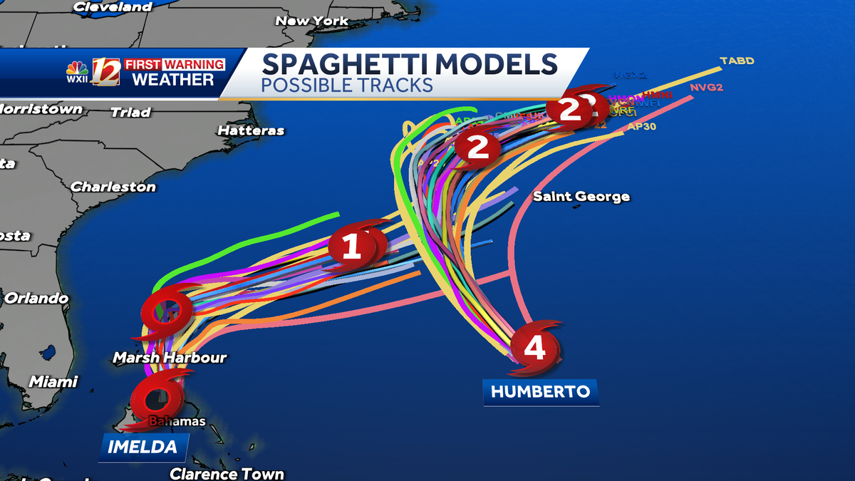
This is a complex forecast given the fact that two tropical systems will be in close proximity. Their interaction may still impact track and intensity over the next few days. There is increasing confidence in the track of Imelda, as most spaghetti model plots steer Imelda away from the coast. Humberto helps steer the storm to the east along with a westward moving upper low-pressure trough on the East Coast.
Tropical Advisory: Imelda and Hurricane Humberto

Tropical Tracks: Humberto and Imelda

Tropical Spaghetti Model Plots: Humberto and Imelda

Slideshow: Check out looping satellites and forecast models
1 of 20
Tropical Track and Looping Satellite: Imelda
2 of 20
Tropical Advisory: Tropical Storm Imelda
3 of 20
Tropical Forecast Track and Advisory: Humberto and Imelda
4 of 20
Tropical Advisory: Humberto
PHOTO: WXII 12 Weather
5 of 20
Tropical Storm-Force Wind Probability: % Chance of Wind Above 39 mph
6 of 20
Piedmont Triad, North Carolina: Wind Gust Speed in Miles Per Hour and Radar
7 of 20
Current and Recent Rainfall Intensity and Wind Gust Speed in Miles Per Hour: Georgia and South Carolina:
8 of 20
Current and Recent Rainfall Intensity and Wind Gust Speed in Miles Per Hour: Piedmont Triad, Foothills and Mountains
PHOTO: WXII 12 Weather
9 of 20
Wind Gust Speed Forecast in Miles Per Hour: Piedmont Triad in North Carolina
10 of 20
Tropical Forecast Wind Gust Speed in Miles Per Hour: North Carolina and South Carolina
PHOTO: WXII 12 News
11 of 20
Potential Tropical Rainfall: GFS Model for rain in North Carolina
12 of 20
Tropical Potential Rain and Storms: EURO Model
13 of 20
Tropical Potential Rain and Storms: GFS Model
14 of 20
Sea Surface Water Temperature in the Atlantic
15 of 20
Tropical Infrared Satellite
This shows satellite imagery for the last few hours and includes any areas of interest and current named tropical systems that may be active in the Atlantic Ocean. For more information, check out our WXII 12 First Warning Interactive Radar and use the tropical layers.
16 of 20
Tropical Ocean: Wave Height in the Atlantic and Gulf
PHOTO: WXII 12 Weather
17 of 20
Current and Recent Wind Gust Speed in Miles Per Hour: Puerto Rico and the Antilles
18 of 20
Current and Recent Wind Gust Speed in Miles Per Hour: Florida and The Bahamas
PHOTO: WXII 12 News
19 of 20
Current Wind Gust Speed in Miles Per Hour: Mid-Atlantic
This image shows Ocean and bay buoy wind gust speed data in miles per hour.
20 of 20
Tropical West Africa Infrared Satellite Imagery
National Hurricane Center meteorologists are issuing advisories on Tropical Depression Nine and Hurricane Humberto, and the National Oceanic and Atmospheric Administration have Hurricane Hunters crews flying into the storms to gather more details.
Two Storms Interact Near Coast
Tropical Storm Imelda and Hurricane Humberto are projected to move between the North Carolina coast and Bermuda. Imelda may ride over the Gulf Stream and influence Humberto’s journey too over the Atlantic. The twin tropical systems may interact with one another and change storm intensities as well as tracks when they approach the Southeast U.S. coast early this coming week. For more about the Fujiwhara effect that occurs when two tropical cyclones are close enough to one another, read Meteorologist Michelle Kennedy’s story here.
This content is imported from YouTube.
You may be able to find the same content in another format, or you may be able to find more information, at their web site.
Forecast Challenges
We expect a lot of updates to the forecast since Imelda has formed into a tropical storm. This is expected to happen between now and Sunday evening. There are several forecast challenges as we monitor the tropics through the weekend. Challenges include:
What happens with the steering currents aloft How much wind shear may impact Nine? What will Humberto’s intensity and forward movement be as Imelda forms from Tropical Depression Nine? Could a surface boundary and a ridge of high pressure keep Imelda near North Carolina’s coast longer and produce more rainfall?
Humberto’s swells may reach the Carolinas on Monday
There is a lot of uncertainty about whether Imelda will be close enough to the North Carolina coast to bring major impacts since the storm track is farther south and east. However, coastal impacts from big waves and rip currents are already developing as swells will reach shores in the Carolinas by Monday. Click here for more about tropical impacts expected in North Carolina, maps, models and beach forecasts..
Hurricane Humberto becomes second Category 5 hurricane of the 2025 season
Humberto became a powerful Category 5 hurricane over the open Atlantic on Saturday afternoon with hurricane-force winds of 160 mph extending out 25 miles from the center of the storm and tropical storm-force winds extend 125 miles from the eye. The hurricane is on a west-northwest track moving at 14 mph while Tropical Storm Imelda is moving slowly at north at 9 mph.
Areas to Watch in the Tropics
Over the next few weeks, the WXII 12 First Warning Weather Team will be focused on three main areas for tropical development:
The Gulf: Very warm sea surface temperatures can help fledgling storms explode into monster hurricanes quickly under the right atmospheric conditions.Africa: In late summer, waves of low pressure often move from the Sahara Desert into the eastern Atlantic. They can develop into tropical systems over time. The sub-tropical high-pressure system over the Atlantic will often steer these systems through the tropical Atlantic towards Central America and the United States.Southeast U.S. Coast: Weaker, short-lived storms often form in late summer or fall along the old frontal boundaries. Areas of offshore low pressure can become tropical. These storms can become dangerous quickly because they are so close to the coast.
Are you prepared for inland tropical impacts in North Carolina and Virginia?
September and October are historically the busiest tropical months for the Carolinas. The 2025 Atlantic hurricane season continues through Nov. 30.
Piedmont Triad residents can stay alert, informed and prepared:
WXII INTERACTIVE STUDIO: EXPLORE MORE
Lanie Pope explains Helene’s massive flooding, why it was potentially a 100-year flood event for the state in the interactive video featured below:
It’s the worst of the worst to ever hit North Carolina, as Dylan Hudler explains the names our state will never forget in the interactive video featured below:
It’s not just the coast that gets hit with devastating impacts from hurricanes, as Brian Slocum explains, why monster storms leave lasting impacts in the interactive video featured below:
Hurricane Hugo brought massive devastation to the Carolinas, as Dave Aiken explains with an in-depth look at the disastrous storm in the interactive video featured below.
Find out the best ways to prepare for hurricane season as Michelle Kennedy explains what you can do now instead of waiting to do later in the interactive video featured below:
More weather coverage: Weather Alerts | Closing and delays | Latest weather forecast | Post pictures to the uLocal North Carolina Facebook Group | Traffic information | Report closings and delays | SkyCams | Download the WXII12 News mobile app