Watching the tropics: North Carolina impacts possible from developing low near Florida
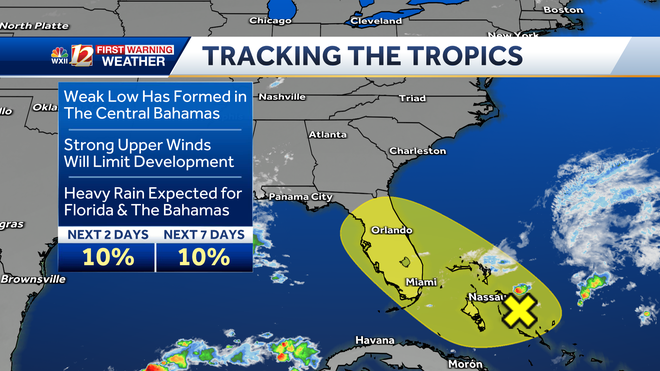
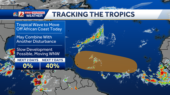
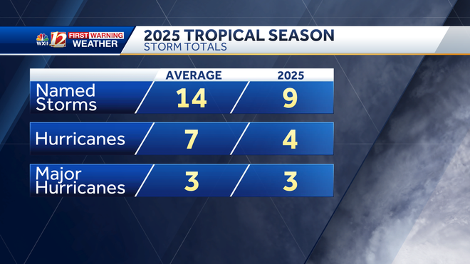
TODAY, AND DO WE THINK ON THE COAST, THE WORST OF IT’S OVER? BRIAN, WE’RE PAST TYPICAL PEAK SEASON. LINDSEY. BUT WE’VE GOT SOME ACTIVITY THAT’S STILL LEFT. I MEAN, THE PROJECTIONS WERE TO HAVE A SEASON THAT WAS ABOVE AVERAGE. WE’RE ONLY AT NINE STORMS AS OF YET, AND IT LOOKS LIKE THERE ARE A COUPLE OF THINGS THAT ARE GOING TO START BREWING HERE FAIRLY SOON. WE’LL GET TO THAT HERE IN A SECOND. BUT 14 NAMED STORMS IN AN AVERAGE SEASON, A LOT OF THE FORECASTS ARE FOR 15 OR MORE. WE’VE HAD THREE MAJOR HURRICANES OUT OF FOUR HURRICANES IN TOTAL. HONESTLY, IMELDA WAS THE ONLY ONE THAT WASN’T A MAJOR HURRICANE AS OF YET, BRINGING THAT TOTAL TO NINE. OF COURSE, A COUPLE OF AREAS OF INTEREST THAT HAVE POPPED UP JUST IN THE LAST 24 HOURS OR SO. WE’LL START WITH THE ONE THAT’ COMING OFF OF AFRICA, BECAUSE THAT IS THE ONE HAS A BETTER CHANCE FOR DEVELOPMENT, AND THAT’S UP TO ABOUT 40%. THE WAVE IS JUST BEGINNING TO EMERGE OFF OF AFRICA. IT’S GOING TO TAKE SOME TIME TO KIND OF SIMMER IN THE TROPICAL ATLANTIC FOR A COUPLE OF DAYS, AND IT MAY BE LATE NEXT WEEK WHEN IT KIND OF MERGES IN WITH ANOTHER DISTURBANCE THAT THIS COULD BECOME A TROPICAL DEPRESSION, LIKELY BEFORE IT GETS INTO THE CARIBBEAN. IF THIS WERE TO IMPACT THE UNITED STATES, IT WOULDN’T EVEN BE NEXT WEEK. IT WOULD BE THE WEEK AFTER THAT. BUT RIGHT NOW, WE’RE NOT EVEN TALKING ABOUT THAT. BUT IT DOES TAKE THAT LONG, SLOW, FLAT TRACK INTO WARMER WATERS. THE OTHER AREA OF INTEREST IS CLOSE. IT’S AN AREA OF LOW PRESSURE DEVELOPING IN THE CENTRAL BAHAMAS. THIS ONLY HAS A 10% CHANCE OF DEVELOPMENT BECAUSE IT’S DEVELOPING SO CLOSE TO LAND. EXPECTED TO MOVE OVER FLORIDA. ONE THING THIS WILL DO IS BRING MOISTURE INLAND AROUND THAT CIRCULATION, AND THAT’S GOING TO BRING SOME PERIODS OF POTENTIALLY HEAVY RAIN TO GEORGIA AND FLORIDA OVER THE NEXT COUPLE OF DAYS, COULD SEE SOME FLOODING THERE. OTHERWISE, WE’RE IN THE MIDST OF A FALL FEELING FRIDAY. WE’VE GOT SOME MILDER WEATHER THIS WEEKEND. MORE CLOUDS BEGIN TO DEVELOP. RAIN CHANCES REALLY DON’T RETURN UNTIL NEXT WEEK, AND THEY’LL TAKE SOME TIME TO DO SO. LOOK AT THAT BEAUTIFUL BLUE SKY OVER NORTH CAROLINA A AND T STATE UNIVERSITY RIGHT NOW GETTING READY FOR HOMECOMING. WE’VE GOT TEMPERATURES IN THE 60S OUT THERE NOW, UPPER 50S IN OUR WESTERN COUNTIES AND LOWER 60S UP IN HILLSVILLE HIGH PRESSURE, BRINGING THE WINDS DOWN, KILLING THE CLOUD COVER. WE STILL HAVE THAT MOISTURE. AS I MENTIONED, MOVING TOWARD THE COASTLINE, AROUND THE RIDGE AND AROUND THIS AREA OF LOW PRESSURE NEAR THE COAST. SO MOISTURE IS COMING IN FROM A COUPLE OF DIFFERENT SOURCES, KIND OF INUNDATING THE AREA. GOT A FLOOD WATCH ALONG THE COAST IN THOSE LOCATIONS, BUT IT DOESN’T REALLY LOOK LIKE IT’S GOING TO BOTHER US AT ALL FOR THE REST OF TODAY. HERE’S YOUR FARE PLANNER FOR THE TRIAD. TEMPERATURES WARMING UP LIKELY INTO THE LOWER 70S THIS AFTERNOON. IF YOU’RE HEADED OUT THIS EVENING, BRING A JACKET. YOU MAY NEED IT. TEMPERATURES FALLING QUICKLY THROUGH THE 60S AND INTO THE 50S LATER TONIGHT. NORMAL HIGH OF 75 WILL FALL SHORT OF THAT. EAST NORTHEAST WINDS AT 5 TO 10 FOR THE FOOTHILLS. A HIGH NEAR 72. COOL AIR ABOUT TO BE CHILLY FOR TONIGHT’S FOOTBALL GAMES. TOO. MOUNTAIN PLANNER PLANS FOR HIGHS IN THE UPPER 60S A LITTLE BIT LATER ON THIS AFTERNOON. LIGHT EAST SOUTHEAST WINDS. SO FOR FOLKS GOING TO FOOTBALL GAMES, BRING A JACKET, MAYBE BRING A BLANKET TO HAVE ON YOUR LAP. KEEP YOUR LEGS WARM BECAUSE WE ARE LOOKING AT JACKET WEATHER DOWN THE ROAD. A LOT OF AREA EVENTS THIS WEEKEND. WE’LL BRING IN SOME CLOUDS BEGINNING TONIGHT. MOORE DURING THE DAY ON SATURDAY, COMING IN OFF THE OCEAN AND SOME HIGHER CLOUDS OUT OF THE SOUTH AND WEST. MOISTURE LEVELS MAY INCREASE A LITTLE BIT TOO, BUT WE’RE NOT EXPECTING ANY WET WEATHER. MORNING LOWS, AFTERNOON HIGHS BEGIN TO COME UP A BIT, BUT AGAIN, THE RAIN SHOULD HOLD OFF FOR A COUPLE MORE DAYS. GETTING INTO NEXT WEEK. HIGHS LOW TO MID. EXCUSE ME MID TO UPPER 70S FOR MOST DAYS. MUCH BETTER RAIN CHANCES FROM A CO
Watching the tropics: North Carolina impacts possible from developing low near Florida

Updated: 12:40 PM EDT Oct 3, 2025
The tropical Atlantic may remain quiet for a few days in between the remnants of Humberto and Imelda tracking toward the United Kingdom and Ireland. However, meteorologists at the National Hurricane Center are monitoring two areas for potential tropical development in the Atlantic Ocean. The first area of concern is a broad zone east of the Leeward Islands and west of Cabo Verde; this area may begin to develop from a tropical wave within the next seven days. The second area of interest is located near the coast of Florida.The area of interest with the greatest potential for impact on the United States is right near the Florida coast over The Bahamas. Showers and thunderstorms have a low chance for tropical development along a former frontal boundary; It is an area of disturbed weather that is forecast to drift across the Florida Peninsula into the Gulf. This area of rain and storms may still impact North Carolina by Tuesday, even if it doesn’t become tropical.Florida and The Bahamas: Rainfall & Wind Gust Speed Next week’s rainfall totals may depend in part on whether a coastal low forms from the active weather near Florida. There is still uncertainty in the models about whether the potential area of lower pressure will become a more organized system and lift into the Carolinas before a cold front arrives to steer it offshore by midweek. Tropical Potential Development Near The BahamasEastern Atlantic Area of InterestThe next storm names on the list for this year include Jerry, Karen and Lorenzo. Hurricane season ends on Nov. 30. Tropical System Names for the 2025 Atlantic Hurricane SeasonTropical Season So FarThis season brought one landfall to the U.S. coast; Tropical Storm Chantal made landfall at Litchfield Beach in South Carolina on July 6. There have been nine named storms with three major hurricanes (sustained wind speeds of 111 mph or stronger): Erin, Gabrielle and Humberto. Hurricanes Erin and Hurricane Humberto had similar tracks, and both reached Category 5 hurricane strength while over the open Atlantic Ocean. 2025 Atlantic Hurricane Season Storm TracksThis has been a deadly hurricane season in North Carolina, with the first tropical system tracking through the state, Chantal, claiming the lives of six people. Tropical Depression Chantal tracked into North Carolina, bringing tropical rain and flash flooding. Chantal caused localized high-impact flash flooding from Alamance, Orange and Chatham Counties during the night of July 6 into the early morning hours of July 7. For more on the heavy rain of 5-12 inches that caused flash flooding in central North Carolina, Assistant State Climatologist Corey Davis has an in-depth look at the event on his blog, “Rapid Reaction: Tropical Storm Chantal Soaks Central North Carolina,” here. For more on Hurricane Erin’s coastal impacts in North Carolina, Davis has another blog update here. Slideshows: Current tropical images and wind gust speed over the Atlantic
WINSTON-SALEM, N.C. —
The tropical Atlantic may remain quiet for a few days in between the remnants of Humberto and Imelda tracking toward the United Kingdom and Ireland. However, meteorologists at the National Hurricane Center are monitoring two areas for potential tropical development in the Atlantic Ocean. The first area of concern is a broad zone east of the Leeward Islands and west of Cabo Verde; this area may begin to develop from a tropical wave within the next seven days. The second area of interest is located near the coast of Florida.
The area of interest with the greatest potential for impact on the United States is right near the Florida coast over The Bahamas. Showers and thunderstorms have a low chance for tropical development along a former frontal boundary; It is an area of disturbed weather that is forecast to drift across the Florida Peninsula into the Gulf. This area of rain and storms may still impact North Carolina by Tuesday, even if it doesn’t become tropical.
Florida and The Bahamas: Rainfall & Wind Gust Speed

Next week’s rainfall totals may depend in part on whether a coastal low forms from the active weather near Florida. There is still uncertainty in the models about whether the potential area of lower pressure will become a more organized system and lift into the Carolinas before a cold front arrives to steer it offshore by midweek.
Tropical Potential Development Near The Bahamas

Eastern Atlantic Area of Interest

The next storm names on the list for this year include Jerry, Karen and Lorenzo. Hurricane season ends on Nov. 30.
Tropical System Names for the 2025 Atlantic Hurricane Season

Tropical Season So Far
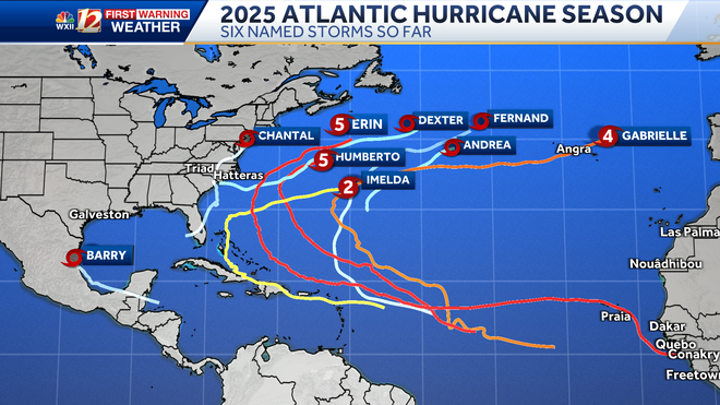
This season brought one landfall to the U.S. coast; Tropical Storm Chantal made landfall at Litchfield Beach in South Carolina on July 6. There have been nine named storms with three major hurricanes (sustained wind speeds of 111 mph or stronger): Erin, Gabrielle and Humberto. Hurricanes Erin and Hurricane Humberto had similar tracks, and both reached Category 5 hurricane strength while over the open Atlantic Ocean.

2025 Atlantic Hurricane Season Storm Tracks

This has been a deadly hurricane season in North Carolina, with the first tropical system tracking through the state, Chantal, claiming the lives of six people. Tropical Depression Chantal tracked into North Carolina, bringing tropical rain and flash flooding. Chantal caused localized high-impact flash flooding from Alamance, Orange and Chatham Counties during the night of July 6 into the early morning hours of July 7. For more on the heavy rain of 5-12 inches that caused flash flooding in central North Carolina, Assistant State Climatologist Corey Davis has an in-depth look at the event on his blog, “Rapid Reaction: Tropical Storm Chantal Soaks Central North Carolina,” here.
For more on Hurricane Erin’s coastal impacts in North Carolina, Davis has another blog update here.
Slideshows: Current tropical images and wind gust speed over the Atlantic
1 of 8
Sea Surface Water Temperature in the Atlantic
2 of 8
Current and Recent Rainfall Intensity and Wind Gust Speed in Miles Per Hour: Georgia and South Carolina:
3 of 8
Current and Recent Rainfall Intensity and Wind Gust Speed in Miles Per Hour: Piedmont Triad, Foothills and Mountains
PHOTO: WXII 12 Weather
4 of 8
Wind Gust Speed Forecast in Miles Per Hour: Piedmont Triad in North Carolina
5 of 8
Tropical Forecast Wind Gust Speed in Miles Per Hour: North Carolina and South Carolina
PHOTO: WXII 12 News
6 of 8
Current and Recent Wind Gust Speed in Miles Per Hour: Puerto Rico and the Antilles
7 of 8
Current Wind Gust Speed in Miles Per Hour: Mid-Atlantic
This image shows Ocean and bay buoy wind gust speed data in miles per hour.
8 of 8
Tropical West Africa Infrared Satellite Imagery
1 of 16
Current Southeast & Atlantic Ocean: Buoy Wind Gust Speeds in Miles Per Hour
2 of 16
Tropical Potential Development Near The Bahamas and Florida
3 of 16
Tropical Activity Potential in the Eastern Atlantic
4 of 16
Current Wind Gust Speed in Miles Per Hour: South Carolina and North Carolina
5 of 16
Current Weather Alerts and Radar
6 of 16
Estimated Wave Height: Current Buoy Data
7 of 16
Georgia, South Carolina and North Carolina: Wind Gust Speeds in Miles Per Hour
8 of 16
Wind Gust Speed in Miles Per Hour: Inveest 90-L Soon to be T.S. Fernand
This image shows ocean buoy data and wind gust speed recorded by automated weather sites during Hurricane Erin’s approach to the North Carolina coast.
9 of 16
Eastern Antilles and Windward Islands Wind Gust Speeds in Miles Per Hour
This image shows recent wind gusts in miles per hour over the Lesser Antilles and the Eastern Atlantic Ocean. Ocean buoy data is also included.
10 of 16
Georgia and the Carolinas Wind Gust Speed & Radar
This image show rain, lightning strikes and wind gust speed in miles per hour from Georgia toward North Carolina.
11 of 16
Florida to North Carolina Wind Gust Speeds in Miles Per Hour
This image shows wind gust speed in miles per hour from Florida to North Carolina. Satellite imagery shows cloud cover and any precipitation along the East Coast through the Outer Banks.
12 of 16
Yucatan Wind Gust Speeds in Miles Per Hour
This image shows wind gust speed in miles per hour for the Yucatan Peninsula, the Gulf, and Texas. Satellite imagery shows cloud cover and any precipitation along the Gulf Coast through Cuba.
13 of 16
Central Caribbean Wind Gust Speeds in Miles Per Hour
This image shows recent wind gusts in miles per hour over the Central Caribbean and the Windward Islands.
14 of 16
Tropical System Categorie Based on Storm Wind Speeds
This chart shows the level of wind speeds in miles per hour that are needed to be categorized as a tropical system.
PHOTO: WXII 12 News
15 of 16
North Carolina Rainfall During Chantal
16 of 16
2024: Hurricane Helene’s Category 4 Landfall Over Florida
Hurricane Helene’s Category 4 Landfall in the Big Bend Area of Florida on September 26 at 11:10 p.m.
PHOTO: WXII 12 Weather

