
RISING WATERS LAB
How Charleston would handle a storm worse than Hugo
By Jonah Chester and Lydia Larsen
September 27, 2026
CHARLESTON — It’s mid-September, and the oceans are near record hot. Wind shear is low, and the sands of the Sahara Desert are calm. Out in the Atlantic, everything is in place.
Details about the series
Details about the series
Today: How leaders in South Carolina prepare for a “worst-case scenario” — a direct strike from a Category 5 hurricane
Monday: How South Carolina would endure the wrath of a highest-level superstorm
Tuesday: How the state would recover, slowly, from the devastation wrought by a Cat 5 cyclone
What was a once-disorganized storm system begins to rotate around a center point, the eye. It has evolved from a loose grouping of thunderstorms to a very low-end cyclone.
At the National Hurricane Center in Miami, meteorologists are watching this tropical depression. They’ve been monitoring the disorganized system near the coast of Africa for days. On their forecast map, they officially declare that a storm has formed and mark its location with a single point.
Word goes out. Early plans take shape. Meetings are convened over conference calls and in board rooms across the state. Emergency response systems begin to activate and prepare. It will be days yet until the state knows exactly what’s coming. For now, officials watch with a wary eye.
Over a week from now, this storm will slam into Charleston County as a Category 5 storm with 165 mph winds, and a storm surge around 18 feet. Roofs will be peeled clean off homes, boats will be tossed onto streets like children’s toys, and Charleston’s iconic historic district will be decimated.
The storm will be over in just a few hours, but the impact will last decades.

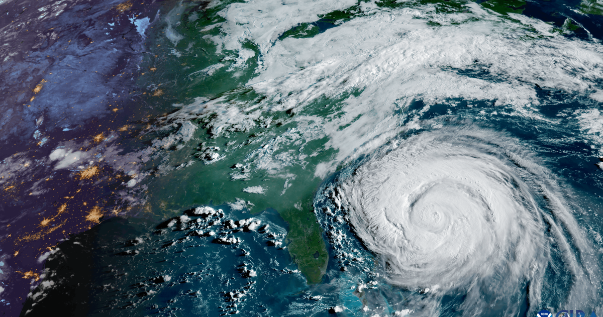
Category 5 Hurricane Erin spins off the southeast coast of the U.S. in August 2025. Erin was one of three Cat 5 hurricanes the Atlantic spawned in 2025.
NOAA/CIRA/Provided
“ What we’re talking about is a storm that Charleston has never seen before,” said Justin Pierce, the county’s director of emergency management. “A Category 5 hurricane striking anywhere in the county is a low-frequency event, but with catastrophic consequences.”
In South Carolina, people are being paid to consider and prepare for this worst case scenario. For many state and local officials, a Category 5 storm is the crisis they spend their whole careers training to confront.
That worst-case scenario, while still a remote possibility, is becoming more likely. The half-century from 1950 to 1999 produced 15 Category 5 hurricanes. In the quarter-century since, 21 storms have reached Category 5 status, according to data from the National Weather Service.
Warming oceans are feeding storms more energy, fueling into higher winds and heavier rainfall, according to NASA.
Hurricane Melissa was a Category 5 storm when it made landfall in Jamaica in October 2025.
NOAA/CIRA/Provided
This season has been a record-setting year for hurricanes in the Atlantic: none have formed yet. A big reason is the super-heated El Niño in the Pacific that has smothered all hurricane activity on this side of the globe, while activating it in the Pacific.
This peaceful period in the Atlantic follows the white-hot 2025 season, which spawned three Category 5 hurricanes — the second highest number on record for a single Atlantic season, according to the National Oceanic and Atmospheric Administration.
Each hurricane is unique. Tide levels, wind speed, landing point and many other factors influence a tropical cyclone’s destructive potential. As the storm grows and evolves, emergency managers and federal weather forecasters will use software to calculate what they should expect.
Pierce is one of the calculators. A Cat 5, he says, “would not look like a stronger version of a storm we’ve ever experienced here before. It would be fundamentally different even from (Hurricane) Hugo.”
Hugo struck as a Category 4 storm when it made landfall in September 1989 at Sullivan’s Island, with maximum winds estimated at 135-140 mph. It was, at the time, the strongest storm measured in the U.S. in the previous 20-year period, according to the National Weather Service, and left a trail of destruction costing more than $7 billion.
Gwylene Gallimard walks her bike by a building on Hayne Street in downtown Charleston that was destroyed by Hurricane Hugo. Hugo slammed into the South Carolina coast as a Category 4 hurricane overnight on Sept. 21, 1989. At 250 miles in circumference, the storm was the same size as the Palmetto State. When it made landfall, its wind speed measured 137 mph.
File/Staff
Five days out
Meteorologists at the National Hurricane Center use a bevy of resources to monitor the fledgling storm. At this point, it’s a spinning tropical depression in the mid-Atlantic. Maximum sustained winds hover around 30 miles per hour, the equivalent of a gusty day at the beach.
Ships out at sea, weather buoys, radar and satellites are feeding thousands of data points back to Miami. It all goes into models developed over decades. These systems are not gospel. The storm is still young, and there’s a lot of variability and potential outcomes.
As the low-pressure system moves closer to the United States, it grows, passing the 39-miles-per-hour threshold and becoming a tropical storm.
Hurricane hunters are dispatched. These NOAA planes spend hours flying inside the storm. The scientists on board use doppler radar to scan the system, and drop tools into the clouds that record and transmit atmospheric pressure, humidity and temperature as they fall towards the ocean.
Back in Miami, meteorologists are pulling all the available information on the storm to forecast the system’s track, intensity and size. This creates the iconic cone graphic that begins making the rounds on news stations and Facebook.
The further out the prediction, the harder the storm is to forecast. The cone gets wider as time stretches out, and the possibilities seem endless.
Hurricane Humberto grew to a Category 5 storm in the open Atlantic in September 2025. While it never made landfall, Humberto was strong enough to pull the nearby Hurricane Imelda out to sea just before the latter storm slammed into the southeast coast.
NOAA/CIRA/Provided
As the storm churns, the governor and emergency management leaders across the state meet to determine what course of action to take.
The spinning cyclone continues to swell, crossing the 74 mph boundary into a Category 1 storm.
As the days go on, the forecast locks in. All models point toward strengthening of the system.
The storm picks up speed. It hits 96 miles per hour. The Cat 2 threshold has been breached.
In Columbia, plans start to take shape.
Faster and faster, spinning like a top, the storm siphons heat off the ocean.
It is becoming increasingly clear that an evacuation is necessary.
The Herculean task of moving hundreds of thousands of people out of harm’s way begins.
Ben Webster, deputy director of emergency management with Charleston County, goes over the layout of the Emergency Communications Center at the Charleston County Emergency Management building, Friday, Sept. 25, 2026, in Ladson.
Gavin McIntyre/Staff
Three days out
More than half-a-million people have been told to leave their homes, pack their cars, and begin moving inland. It’s a process that, beginning to end, will take several days.
The storm hovers at a low-end Category 3. The governor declares a state of emergency and calls for a complete evacuation of all three Charleston County evacuation zones.
The process would take at least 72 hours — with emergency officials making their final recommendations to the governor three days before the arrival of the storm. Full resident and tourist clearance time is around 45 hours for the three evacuation zones in Charleston County, and 60 hours for all six zones in the Central Hurricane Region (including Charleston, and parts of Berkeley and Dorchester Counties), according to the S.C. Emergency Management Division.
State officials implement a lane reversal in Interstate 26. Bumper-to-bumper traffic crawls away from the city.
South Carolina’s hurricane evacuation zones for the central coast. More info can be found on hurricane.sc.
SCEMD/Provided
“ If we have a large-scale evacuation, we bring in (crews) … from other parts of the state to support an evacuation, on top of the guys that are already down there,” says Justin Powell, the state’s secretary of transportation. “The main goal is just to try to get disabled vehicles out of the way as quickly as possible.”
Utilities prepare for the inevitable damage. Charleston Water System halts construction on its facilities and tells workers to break down their cranes and get off the coast.
Plans are made to switch water treatment plants in Hanahan and on Plum Island over to generator power. Every tank in Charleston Water System’s fleet is topped off with diesel, which will become a precious commodity in the days following the storm.
The water utility is constantly receiving truck loads of chlorine and other chemicals used in the water treatment process. The plants can only last a few days without them, Chief Operating Officer Baker Mordecai said. They begin calling suppliers to make plans.
Staff for Charleston Water System and electric utilities pre-stage equipment in different parts of the metro area in case bridges are damaged or shut down.
An Emergency Communications Center vest wraps around a chair inside the center at the Charleston County Emergency Management building, Friday, Sept. 25, 2026, in Ladson.
Gavin McIntyre/Staff
“We have 225 pump stations, a very large collection system, and a distribution system of 1,600 miles,” Mordecai said. “So we want to make sure that we have heavy equipment to handle emergencies in each of those areas.”
The effects of the storm extend beyond the coast. Utilities activate long-standing mutual aid agreements, a formal contract that requires the water system and electric co-ops to assist each other in times of need.
A preemptive call goes out for linemen across the region to assist in restoring power, but they won’t act until landfall.
Hospitals and nursing homes have been moving in the other direction. Patients and staff are being shuttled away from the danger, Louis Eubank, director of emergency preparedness at the Department of Public Health, says. Much like the utilities, the plan for evacuating the hospitalized and nursing home residents depends on the mutual aid agreement.
Back out in the Atlantic, the system is strengthening. Now a Category 3 storm, pushing it over the boundary into a “major” hurricane, the system’s wind speeds have grown to 120 mph.
Fueled by the waters warmed by the climate crisis, the storm is about to undergo a sudden and aggressive growth spurt.
Two days out
The evacuation continues. Honking, road rage, fender benders — typical traffic problems, but on steroids.
Emergency responders begin to pre-position crews in buildings designed to withstand major hurricanes and equipped with generators. These people will aid in the post-storm response, and their facilities are for essential personnel only.
“ When we talk about a Category 5 storm, emergency shelters are not an option,” Charleston County’s Pierce says. “We do not have the shelters in place that can withstand the wind speeds of a Cat 5 storm. The plan, and the only plan, for a Category 5 hurricane direct hit is to evacuate.”
In the Atlantic, the storm is growing, but not at the pace it has over the past few days. Hurricane Hunter aircraft continue their missions, and the information they send back to Miami is alarming: the winds are picking up and the pressure is dropping — fast.
Hurricane Gracie was a Category 4 storm when it hit South Carolina in 1959. Here, storm surge can be seen washing over Charleston’s Low Battery.
File/Staff
Over the next day the Cat 3 system will rapidly intensify into a Category 5 storm.
During the 2025 Atlantic hurricane season, four different storms underwent rapid intensification, where a storm’s wind speeds increase by at least 35 mph (or roughly one category level) in a 24-hour period. Three of those underwent “extreme rapid intensification” (58 mph or more in a 24-hour period) and ballooned to Category 5 storms, per NOAA.
This trend has become more common in recent years. One 2023 study found that Atlantic hurricanes now are more than twice as likely to zip from minor storms to catastrophic events compared to 50 years ago.
Throughout this entire process, the governor’s office, state agencies and local officials are communicating constantly. The call is made to expand the evacuation order to all six zones in the Central Hurricane Region, which includes Charleston and parts of Berkeley and Dorchester counties.
A vehicle is submerged in floodwaters at Unity Park, Sept. 27, 2024, in Greenville after Hurricane Helene struck.
File
Susan Cutter, a professor of geography at the University of South Carolina, is confident that the state’s current evacuation process is up to snuff to quickly adapt to the threat — even taking into account rapid intensification.
“ You’re always gonna have a group of folks that are gonna be a little reluctant to (evacuate),” said Cutter, who previously led USC’s Hazards Vulnerability & Resilience Institute. “But I’m pretty confident that they’ve got that one under control.”
The decision makers hole up in their emergency management centers: Charleston Water System in Hanahan to monitor their system; Berkeley electric co-op in Moncks Corner; City of Charleston officials downtown at the Galliard Center.
Firefighters in their stations soon are relocated to safer areas as the storm approaches.
Charleston Water System’s Director of Environmental Services Jonathan Walker walks the catwalk between water storage tanks in one of the last steps before the treated water is returned to the harbor, Friday, March 21, 2025, in Charleston.
File/Henry Taylor/Staff
One day out
Everyone has a plan. The National Weather Service office at Charleston International Airport joins a conference call with the National Hurricane Center in Miami every six hours.
At this point, the forecast is as clear as it can be. The hurricane is headed for Charleston. What’s left is tailoring the storm forecast to the region’s unique geography, a fine tuning process to predict the most accurate storm surge, rainfall and wind warnings possible.
A map of the shore line lights up with watches, then warnings.
Officials issue a final plea to evacuate. Some long-time residents decide to weather out the storm.
This isn’t their first rodeo. Some remember Hugo’s wrath. They survived that, and they believe they’ll survive this. How much worse can it possibly be?
The state overhauled its evacuation zones in 2024 to try and address this evacuation fatigue and reticence to leave homes. The result is a more “surgical” approach to evacuation orders, and one that takes into account the region’s population growth, says Kim Stenson, the director of the South Carolina Emergency Management Division.
Many people will ignore the warnings.
A smattering of rain begins to fall as the storm’s outer bands brush the coast. Along the beaches, waves grow taller.
How we reported this project
How we reported this project
The Post and Courier spoke with officials across more than a dozen utilities, state and local agencies to find out the answer to three questions: What would a Category 5 storm do to the Palmetto State’s coast? How do they prepare? How would a recovery unfold? In addition to these interviews, we referenced multiple peer-reviewed scientific studies, federal databases, National Weather Service storm reports, and The Post and Courier’s substantial past coverage of hurricanes and environmental issues.