
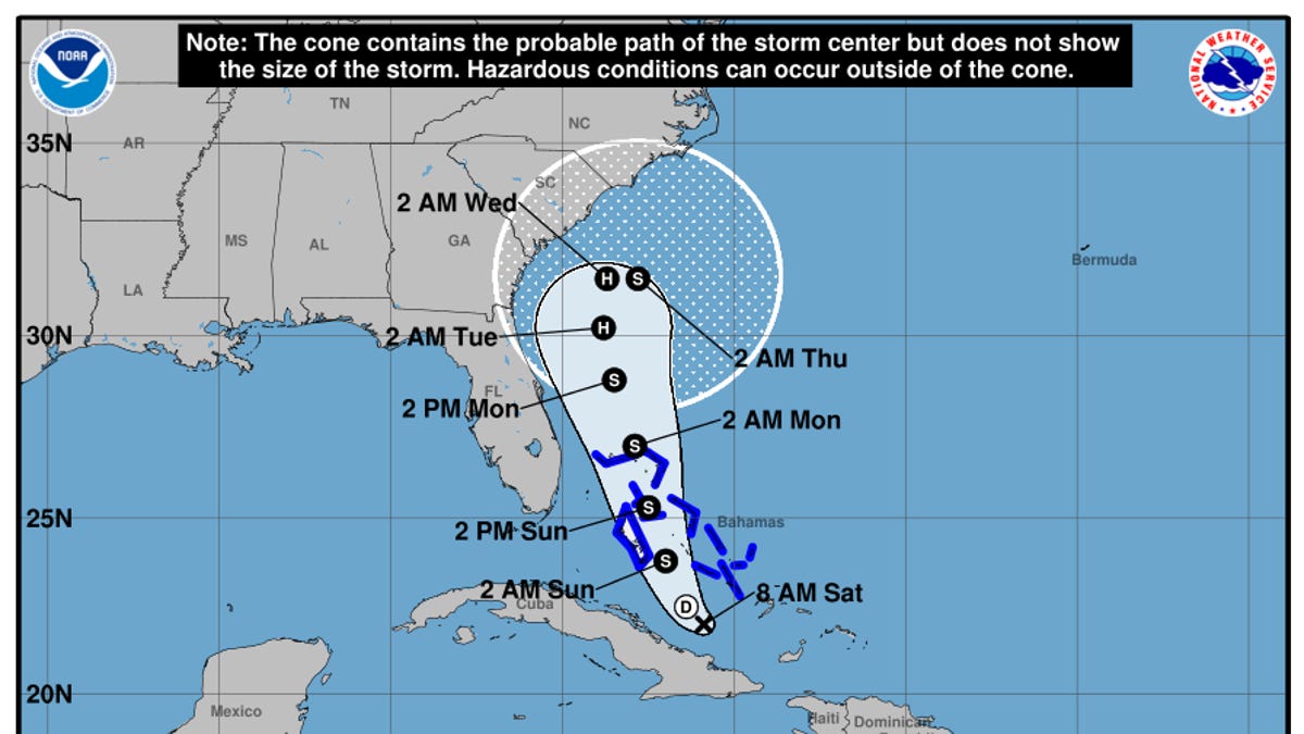
The National Hurricane Center’s forecast track warns a new system, to be named Imelda, could stall offshore and dump heavy rain on the Southeast.
![]()
Rare Humberto-Imelda dual storm raises US hurricane risk
A rare weather setup is forming in the Atlantic, where two tropical systems may develop dangerously close to each other early next week.
unbranded – Newsworthy Vertical
Hurricane forecasters are watching three major risk factors for people across a swath of the East Coast, a complex dance of weather that has led to a troubling forecast for late September.
First, Hurricane Humberto is roaring out in the Atlantic Ocean as a major hurricane. Second, another storm that strengthened into a tropical depression on Sept. 27 will soon be named Imelda and is expected to travel parallel to a stretch of coastline from Florida to the Carolinas. And third, unrelated rain is expected in the southeastern United States.
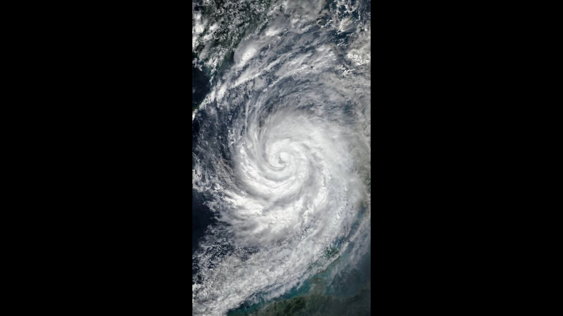
Humberto intensified to a Category 5 by 5 p.m., but is not presently considered a major threat to the United States. Humberto is the second Category 5 hurricane of the 2025 Atlantic hurricane season, with Hurricane Erin in August being the first.
The three weather systems may interact with each other, possibly in a dramatic and chaotic fashion, leading to added uncertainty.
On Saturday, Sept. 27, the forecast calls for heavy rain, dangerous surf and high-end tropical storm-force winds to begin arriving along the Southeastern U.S. coast by Sept. 29 as potential Tropical Storm Imelda approaches from the Bahamas and Hurricane Humberto roughs up the ocean from several hundred miles to the east.
A tropical storm watch was issued for the east coast of Florida from the Palm Beach-Martin County line to the Flagler-Volusia County line on Sept. 27 after the tropical depression formed, indicating tropical storm conditions are expected within 48 hours. Rip currents are expected to intensify at beaches along Florida’s east coast over the next day, the National Hurricane Center said.
Imelda could form, stall and dump rain on Southeast
The National Hurricane Center’s official forecast track calls for the new system – now dubbed Tropical Depression Nine – to become a tropical storm by the evening of Sept. 27, then briefly a hurricane by early next week off the Florida coast. The forecast calls for it to slow and weaken as it approaches the South Carolina coast on Sept. 29 to 30, and could spend nearly 24 hours in virtually the same location just offshore.
Slow-moving storms mean heavy rain becomes “a significant threat,” said hurricane center director Michael Brennan. “We don’t know exactly where that heaviest rainfall will occur, but that would be in addition to some of the heavy rainfall we’re seeing across portions of the southeastern United States this weekend.”
“There’s an increasing threat of heavy rainfall early next week from coastal Georgia through the Carolinas and into the Mid-Atlantic states, which could cause flash, urban, and river flooding,” Brennan said. “So, everybody along the coast of South Carolina, North Carolina, from Georgia, all the way up into the southern mid-Atlantic states is going to want to pay attention to the forecast for this system as we go throughout the weekend.”
However, greater uncertainty than normal remains in the forecast.
As the storm approaches, a combination of factors is not providing meteorologists the comfort they’d like in making their forecasts. That includes the influence of an approaching cold front and upper-level disturbance over the region, questions over the speed and timing of the system and Humberto, and the potential for an unusual interaction between the two tropical systems as they approach each other early in the week of Sept. 29 that could affect one or both of their trajectories.
Meanwhile, the unrelated rain event bringing heavy rain into the Appalachians and Southeast is setting up a potential for greater flooding even before the tropical weather moves in.
Hurricane Humberto and the Fujiwhara effect
At 5 p.m. Sept. 27, Humberto was a Category 5 hurricane with maximum sustained winds of 160 mph. Humberto rapidly intensified the previous day; its wind speeds increased by 80 mph in 24 hours. Humberto was centered about 350 miles north-northeast of the Northern Leeward Islands, moving west-northwestward at 10 mph.
Despite the Category 5 classification, there are no coastal watches or warnings in effect. Swells from Humberto are expected to affect the U.S. East Coast beginning Monday, likely causing life-threatening surf and rip current conditions, according to the NWS.
Humberto quickly strengthened since 11 a.m. on Sept. 27 when it was a Category 4 hurricane with maximum sustained winds of 145 mph. Although Humberto is already the second Category 5 hurricane of the 2025 Atlantic hurricane season, the NWS forecaster David Zelinsky said, “Some additional strengthening is possible tonight.”
For days now, computer models used in forecasting have been hinting at the potential for a Fujiwhara effect between Humberto and the potential tropical storm, said Brian McNoldy, a senior research associate at the Rosenstiel School of Marine, Atmospheric and Earth Science at the University of Miami.
The Fujiwhara effect is a phenomenon that occurs when two cyclones near each other begin to spin around a common center point between them rather than moving independently. That interaction could cause one storm to absorb another, the two storms to merge or both storms to move off in different directions.
That potential “makes the track and intensity forecast for each more challenging,” said Dan Brown, hurricane specialist branch chief at the hurricane center. As a result, the hurricane center and its partners have been scheduling frequent flights over the western Atlantic in the hurricane hunter aircraft to collect information about the storms and their surrounding environment, Brown said. The weather service has also been launching additional weather balloons to gather atmospheric information.
On Sept. 26, one model showed a one-in-three chance of the Fujiwhara effect, McNoldy told USA TODAY. “It’s certainly within the realm of possibilities that Humberto and future-Imelda rotate around a common ‘centroid’ in the Sunday-Tuesday timeframe,” he said.
As a rough rule of thumb, the separation distance between the storm centers needed for the mutual attraction to occur is around 800 miles, but that’s not a hard and fast number, he said. Their relative sizes and intensities also have an influence.
“Since Humberto will be so much larger and stronger, the centroid would be much closer to Humberto’s center, so that storm’s track would only feel a slight nudge, while future-Imelda could feel a significant tug and even get slingshot out to sea before reaching the coast.”
On the other side of the situation, each of the two storms could move on, each as if the other didn’t exist, he said.
Heavy rain ahead of tropical weather creates another layer of danger
The chance for serious flooding is thanks in part to a weather phenomenon that meteorologists call a PRE or Predecessor Rain Event.
“The setup this weekend could produce a Predecessor-like Rain Event or PRE well ahead of future Imelda,” said WPLG-TV hurricane specialist Michael Lowry on Sept. 26. “A PRE is a heavy rainfall event that can occur hundreds of miles north of a tropical system from a channel of rich tropical air flowing toward a frontal zone.”
These PREs are usually worsened by the presence of a nearby upper-level area of low pressure that helps trigger the atmosphere to wring out the copious tropical moisture overhead, Lowry said.
An extreme version of this happened a year ago in the North Carolina and Tennessee mountains ahead of Hurricane Helene.
Landslide in Great Smoky Mountains closes Tennessee’s Gatlinburg Bypass
The Gatlinburg Bypass in Tennessee is currently closed due to a landslide blocking the roadway, according to a message from Great Smoky Mountains National Park.
Neither the size of the landslide nor the estimated reopening time was shared by the National Park, and officials did not immediately respond to USA TODAY’s request for comment.
Sevier County Emergency Management Department told the Knoxville News Sentinel, part of the USA TODAY Network, that flash floods are causing road closures.
The closures come as an unrelated rain event brings heavy rain into the Appalachians and Southeast, which could also potentially lead to greater flooding. The rain event, or PRE, may have been worsened by the nearby upper-level area of low pressure that was forecasted for this weekend over the Tennessee Valley, said Lowry on Sept. 26.
Update: The Gatlinburg Bypass is closed until further notice due to a large landslide that occurred Saturday morning following heavy rainfall. pic.twitter.com/ZInzQFNb5M
— GreatSmokyNPS (@GreatSmokyNPS) September 27, 2025How much rain could fall in the Southeast?
Between 5 and 10 inches of rain could fall in the coastal southeastern parts of North and South Carolina through the first couple of days of October, the Weather Prediction Center said. Higher totals could fall locally and could lead to “scattered pockets of flash flooding,” the Weather Prediction Center said.
From far eastern Georgia to central Virginia, 2 to 4 inches could fall, while the Carolina coasts could see upward of 8 to 16 inches, according to AccuWeather meteorologists.
“Rainfall of this magnitude can lead to widespread life-threatening flooding, especially if the storm slows down or stalls,” AccuWeather said.
Track the path of storms in the Atlantic
This forecast track shows the most likely path of the center of the storm. It does not illustrate the full width of the storm or its impacts, and the center of the storm is likely to travel outside the cone up to 33% of the time.
(This story has been updated to add new information.)