
Two tropical systems are slowly churning up the East Coast this week, and swells will increase wave heights from Charleston, South Carolina, all the way north toward Virginia Beach. Marine concerns are rising, and travelers embarking on cruises can expect travel delays or changes to itinerary for travel in the Atlantic through much of the coming week.Two Tropical Systems: Humberto & ImeldaHurricane Humberto maintained wind speeds of around 140 mph as it tracked northwest on Sunday. The current forecast from the National Hurricane Center has Humberto making an important turn to the north and then northeast on Tuesday into Wednesday. During the weekend, Humberto became the second Category 5 hurricane of the 2025 Atlantic hurricane season with sustained winds of 160 mph. It has since weakened and will continue that trend in the coming days as it moves over cooler Atlantic waters in a few days.Tropical Storm Imelda’s Forecast ConeThe second active tropical system, Imelda, is also in the Atlantic basin at the same time as Hurricane Humberto. Imelda became a tropical storm on Sunday afternoon. Early forecasts showed Imelda strengthening along the warm waters near The Bahamas before making landfall somewhere along the east coast. However, Imelda’s forecast has shifted significantly since the low-pressure center formed on Sunday; Imelda is forecast to make only a brief parallel passage about 150 miles off the Florida coast before turning out to sea and following its tropical twin, Hurricane Humberto, heading eastward. Tropical Storm Warnings in FloridaThe National Hurricane Center meteorologists are issuing tropical advisories. You can also find tropical advisories in Spanish here. Advisories for the massive Hurricane Humberto can be found here; Hurricane Humberto advisories in Spanish can be found here. From Florida to South Carolina, rainfall up to six inches is possible now through Tuesday. Although track uncertainty remains, heavy rain ahead of future Imelda may develop Monday and continue through early Thursday with 1 to 3 inch totals possible along the southern coast of North Carolina. Periods of scattered showers and storms may bring up to two inches of rain for parts of the eastern Piedmont Triad.Potential RainfallTropical Storm Imelda is set to track offshore of the CarolinasTropical Storm Imelda may become a Category 1 hurricane soon; major North Carolina inland impacts are less likely on the current track. High impacts to the coastal Carolinas are expected from large swells rolling toward the East Coast from Humberto and Imelda will cause additional marine hazards as it turns away from the coast on Tuesday.The storm was much slower in forward speed and growth than the original forecast projections; therefore, National Hurricane Center meteorologists believe a faster turn to the east may occur. This is a better scenario than earlier forecast tracks for the High Country of North Carolina, where residents were concerned for flooding again from a tropical system so close to the date of Helene’s destruction last year, Sept. 26. Tropical Storm Imelda is moving over The Bahamas as it moves parallel to the Florida Coastline.By Monday evening, Imelda may become a Category 1 hurricaneBy Tuesday Afternoon, Imelda may be a Category 1 hurricane as it turns east-northeast toward Bermuda.On Wednesday evening, it may remain a Category 1 hurricane offshore southeast of the Carolinas.On Thursday evening, the storm may roll farther away from the East Coast and continue east toward Bermuda as it becomes post-tropical.The latest official track has the storm remaining just offshore of Georgia while turning east instead of north toward North Carolina. What to Expect in North CarolinaBeach Hazards: Rip currents and big wavesPiedmont Triad North Carolina areas may receive beneficial rainfall MondayWind Gust Speed in Miles Per Hour: Current Gust Speed in North CarolinaForecast Wind Gust SpeedWave heightSea Surface TemperatureSouthern Beaches ForecastCrystal Coast Beaches ForecastOuter Banks Beaches ForecastAre you ready for tropical impacts in North Carolina?The historically busiest tropical months still lie ahead. The 2025 Atlantic hurricane season continues through Nov. 30.Piedmont Triad residents can stay alert, informed, and prepared by following these tips:Know your evacuation routes and have an emergency plan.Monitor the forecasts on WXII 12 News or WXII12.com.Review insurance coverage and protect important documents, especially in light of past flooding events like Helene (2024) and Chantal (2025).Have an emergency preparedness kit: water, batteries, flashlights, and medications in case of power loss.WXII INTERACTIVE STUDIO: EXPLORE MORELanie Pope explains Helene’s massive flooding, why it was potentially a 100-year flood event for the state in the interactive video featured below:It’s the worst of the worst to ever hit North Carolina, as Dylan Hudler explains the names our state will never forget in the interactive video featured below:It’s not just the coast that gets hit with devastating impacts from hurricanes, as Brian Slocum explains, why monster storms leave lasting impacts in the interactive video featured below:Hurricane Hugo brought massive devastation to the Carolinas, as Dave Aiken explains with an in-depth look at the disastrous storm in the interactive video featured below.Find out the best ways to prepare for hurricane season as Michelle Kennedy explains what you can do now instead of waiting to do later in the interactive video featured below:More weather coverage: Weather Alerts | Closing and delays | Latest weather forecast | Post pictures to the uLocal North Carolina Facebook Group | Traffic information | Report closings and delays | SkyCams | Download the WXII12 News mobile app
Two tropical systems are slowly churning up the East Coast this week, and swells will increase wave heights from Charleston, South Carolina, all the way north toward Virginia Beach. Marine concerns are rising, and travelers embarking on cruises can expect travel delays or changes to itinerary for travel in the Atlantic through much of the coming week.
Two Tropical Systems: Humberto & Imelda


Hearst Owned
Twin Tropical Tracks: Humberto & Imelda

Hurricane Humberto maintained wind speeds of around 140 mph as it tracked northwest on Sunday. The current forecast from the National Hurricane Center has Humberto making an important turn to the north and then northeast on Tuesday into Wednesday. During the weekend, Humberto became the second Category 5 hurricane of the 2025 Atlantic hurricane season with sustained winds of 160 mph. It has since weakened and will continue that trend in the coming days as it moves over cooler Atlantic waters in a few days.
This content is imported from Facebook.
You may be able to find the same content in another format, or you may be able to find more information, at their web site.
Tropical Storm Imelda’s Forecast Cone

The second active tropical system, Imelda, is also in the Atlantic basin at the same time as Hurricane Humberto. Imelda became a tropical storm on Sunday afternoon. Early forecasts showed Imelda strengthening along the warm waters near The Bahamas before making landfall somewhere along the east coast. However, Imelda’s forecast has shifted significantly since the low-pressure center formed on Sunday; Imelda is forecast to make only a brief parallel passage about 150 miles off the Florida coast before turning out to sea and following its tropical twin, Hurricane Humberto, heading eastward.
Tropical Storm Warnings in Florida
This content is imported from Twitter.
You may be able to find the same content in another format, or you may be able to find more information, at their web site.
The National Hurricane Center meteorologists are issuing tropical advisories. You can also find tropical advisories in Spanish here. Advisories for the massive Hurricane Humberto can be found here; Hurricane Humberto advisories in Spanish can be found here.
From Florida to South Carolina, rainfall up to six inches is possible now through Tuesday. Although track uncertainty remains, heavy rain ahead of future Imelda may develop Monday and continue through early Thursday with 1 to 3 inch totals possible along the southern coast of North Carolina. Periods of scattered showers and storms may bring up to two inches of rain for parts of the eastern Piedmont Triad.
Potential Rainfall

Tropical Storm Imelda is set to track offshore of the Carolinas
Tropical Storm Imelda may become a Category 1 hurricane soon; major North Carolina inland impacts are less likely on the current track. High impacts to the coastal Carolinas are expected from large swells rolling toward the East Coast from Humberto and Imelda will cause additional marine hazards as it turns away from the coast on Tuesday.
The storm was much slower in forward speed and growth than the original forecast projections; therefore, National Hurricane Center meteorologists believe a faster turn to the east may occur. This is a better scenario than earlier forecast tracks for the High Country of North Carolina, where residents were concerned for flooding again from a tropical system so close to the date of Helene’s destruction last year, Sept. 26.
Tropical Storm Imelda is moving over The Bahamas as it moves parallel to the Florida Coastline.
By Monday evening, Imelda may become a Category 1 hurricaneBy Tuesday Afternoon, Imelda may be a Category 1 hurricane as it turns east-northeast toward Bermuda.On Wednesday evening, it may remain a Category 1 hurricane offshore southeast of the Carolinas.On Thursday evening, the storm may roll farther away from the East Coast and continue east toward Bermuda as it becomes post-tropical.
The latest official track has the storm remaining just offshore of Georgia while turning east instead of north toward North Carolina.
What to Expect in North Carolina

Hearst Owned
Imelda Coastal impacts
Beach Hazards: Rip currents and big waves

Piedmont Triad North Carolina areas may receive beneficial rainfall Monday

Wind Gust Speed in Miles Per Hour: Current Gust Speed in North Carolina

Forecast Wind Gust Speed

Wave height

Sea Surface Temperature

Southern Beaches Forecast

Crystal Coast Beaches Forecast

Outer Banks Beaches Forecast

Are you ready for tropical impacts in North Carolina?
1 of 26
Tropical Advisory: Imelda
2 of 26
Tropical Track: Imelda
3 of 26
Twin Tropical Tracks: Humberto & Imelda
4 of 26
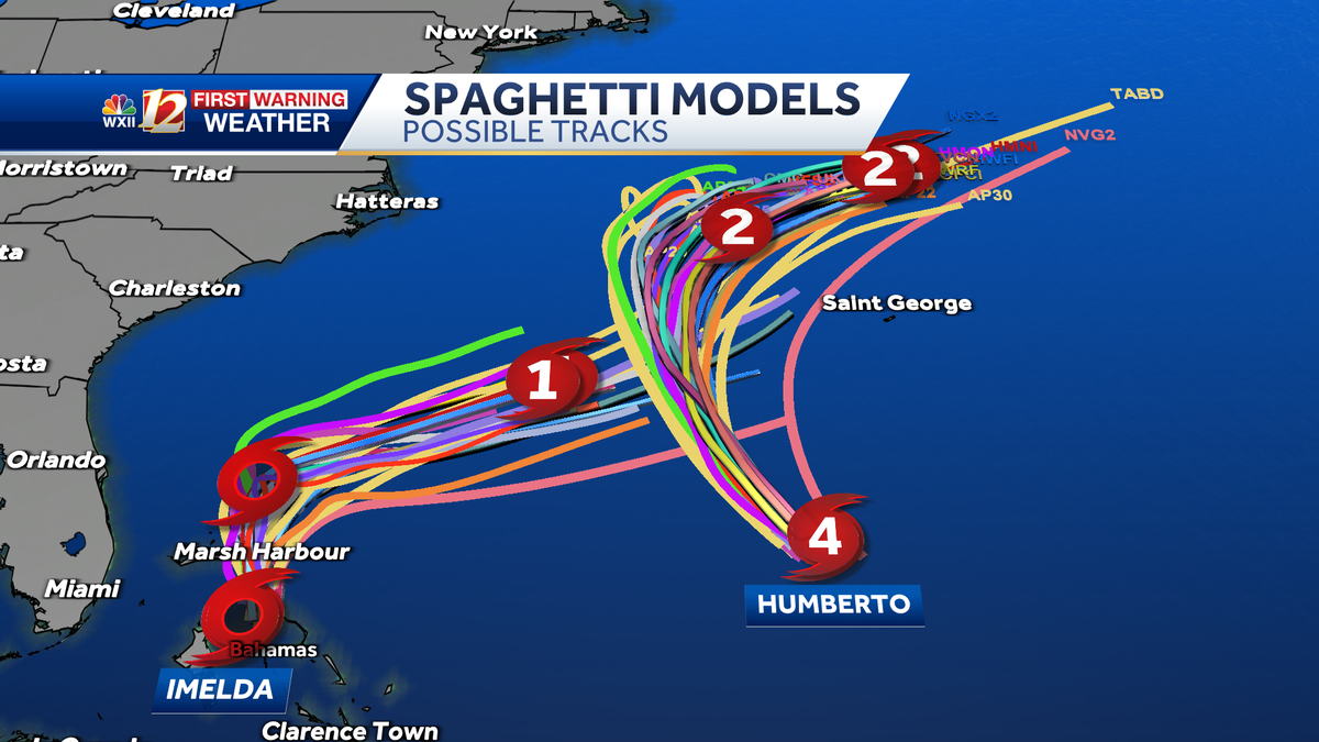
Tropical Spaghetti Plots: Twin tropical systems Humberto and Potential Tropical Cyclone Nine
5 of 26
Tropical Spaghetti Model Plots: Imelda
This shows several different model track possibilities for Imelda, but most forecast models are in agreement with the storm moving out to sea before any U.S. landfall is possible.
6 of 26
Tropical Spaghetti Model Plots: Humberto
This shows several different model track possibilities for Humberto.
7 of 26
Tropical Track: Humberto
Hurricane Humberto may briefly influence the track of Imelda as the hurricane approaches the Carolina coast and then veers away toward the northeast and around Bermuda.
PHOTO: WXII 12 Weather
8 of 26
Current Tropical Alerts and Radar
9 of 26
Current Southeast & Atlantic Ocean: Buoy Wind Gust Speeds in Miles Per Hour
10 of 26
Current Wind Gust Speed in Miles Per Hour: South Carolina and North Carolina
11 of 26
Estimated Wave Height: Current Buoy Data
12 of 26
Potential Tropical Rainfall Along the North Carolina Coast
13 of 26
Georgia, South Carolina and North Carolina: Wind Gust Speeds in Miles Per Hour
14 of 26
Tropical Advisory: Humberto
PHOTO: WXII 12 Weather
15 of 26
Estimated Wave Heights in the Atlantic
16 of 26
Estimated Wave Height in the Atlantic
17 of 26
Tropical Cyclone Heat Potential
There is greater potential for rapid intensification of tropical systems that develop or travel over waternear The Bahamas and Cuba.
18 of 26
Eastern Antilles and Windward Islands Wind Gust Speeds in Miles Per Hour
This image shows recent wind gusts in miles per hour over the Lesser Antilles and the Eastern Atlantic Ocean. Ocean buoy data is also included.
19 of 26
Georgia and the Carolinas Wind Gust Speed & Radar
This image show rain, lightning strikes and wind gust speed in miles per hour from Georgia toward North Carolina.
20 of 26
Wind Gust Speed in Miles Per Hour: Inveest 90-L Soon to be T.S. Fernand
This image shows ocean buoy data and wind gust speed recorded by automated weather sites during Hurricane Erin’s approach to the North Carolina coast.
21 of 26
Florida to North Carolina Wind Gust Speeds in Miles Per Hour
This image shows wind gust speed in miles per hour from Florida to North Carolina. Satellite imagery shows cloud cover and any precipitation along the East Coast through the Outer Banks.
22 of 26
Tropical System Categorie Based on Storm Wind Speeds
This chart shows the level of wind speeds in miles per hour that are needed to be categorized as a tropical system.
PHOTO: WXII 12 News
23 of 26
Central Caribbean Wind Gust Speeds in Miles Per Hour
This image shows recent wind gusts in miles per hour over the Central Caribbean and the Windward Islands.
24 of 26
Yucatan Wind Gust Speeds in Miles Per Hour
This image shows wind gust speed in miles per hour for the Yucatan Peninsula, the Gulf, and Texas. Satellite imagery shows cloud cover and any precipitation along the Gulf Coast through Cuba.
25 of 26
North Carolina Rainfall During Chantal
26 of 26
2024: Hurricane Helene’s Category 4 Landfall Over Florida
Hurricane Helene’s Category 4 Landfall in the Big Bend Area of Florida on September 26 at 11:10 p.m.
PHOTO: WXII 12 Weather
1 of 20
Tropical Track and Looping Satellite: Imelda
2 of 20
Tropical Advisory: Tropical Storm Imelda
3 of 20
Tropical Forecast Track and Advisory: Humberto and Imelda
4 of 20
Tropical Advisory: Humberto
PHOTO: WXII 12 Weather
5 of 20
Tropical Storm-Force Wind Probability: % Chance of Wind Above 39 mph
6 of 20
Piedmont Triad, North Carolina: Wind Gust Speed in Miles Per Hour and Radar
7 of 20
Current and Recent Rainfall Intensity and Wind Gust Speed in Miles Per Hour: Georgia and South Carolina:
8 of 20
Current and Recent Rainfall Intensity and Wind Gust Speed in Miles Per Hour: Piedmont Triad, Foothills and Mountains
PHOTO: WXII 12 Weather
9 of 20
Wind Gust Speed Forecast in Miles Per Hour: Piedmont Triad in North Carolina
10 of 20
Tropical Forecast Wind Gust Speed in Miles Per Hour: North Carolina and South Carolina
PHOTO: WXII 12 News
11 of 20
Potential Tropical Rainfall: GFS Model for rain in North Carolina
12 of 20
Tropical Potential Rain and Storms: EURO Model
13 of 20
Tropical Potential Rain and Storms: GFS Model
14 of 20
Sea Surface Water Temperature in the Atlantic
15 of 20
Tropical Infrared Satellite
This shows satellite imagery for the last few hours and includes any areas of interest and current named tropical systems that may be active in the Atlantic Ocean. For more information, check out our WXII 12 First Warning Interactive Radar and use the tropical layers.
16 of 20
Tropical Ocean: Wave Height in the Atlantic and Gulf
PHOTO: WXII 12 Weather
17 of 20
Current and Recent Wind Gust Speed in Miles Per Hour: Puerto Rico and the Antilles
18 of 20
Current and Recent Wind Gust Speed in Miles Per Hour: Florida and The Bahamas
PHOTO: WXII 12 News
19 of 20
Current Wind Gust Speed in Miles Per Hour: Mid-Atlantic
This image shows Ocean and bay buoy wind gust speed data in miles per hour.
20 of 20
Tropical West Africa Infrared Satellite Imagery
The historically busiest tropical months still lie ahead. The 2025 Atlantic hurricane season continues through Nov. 30.
Piedmont Triad residents can stay alert, informed, and prepared by following these tips:
WXII INTERACTIVE STUDIO: EXPLORE MORE
Lanie Pope explains Helene’s massive flooding, why it was potentially a 100-year flood event for the state in the interactive video featured below:
It’s the worst of the worst to ever hit North Carolina, as Dylan Hudler explains the names our state will never forget in the interactive video featured below:
It’s not just the coast that gets hit with devastating impacts from hurricanes, as Brian Slocum explains, why monster storms leave lasting impacts in the interactive video featured below:
Hurricane Hugo brought massive devastation to the Carolinas, as Dave Aiken explains with an in-depth look at the disastrous storm in the interactive video featured below.
Find out the best ways to prepare for hurricane season as Michelle Kennedy explains what you can do now instead of waiting to do later in the interactive video featured below:
More weather coverage: Weather Alerts | Closing and delays | Latest weather forecast | Post pictures to the uLocal North Carolina Facebook Group | Traffic information | Report closings and delays | SkyCams | Download the WXII12 News mobile app